 Old Cumbria Gazetteer
 |
 |
|
| Grisedale Tarn, Patterdale | ||
| runs into:- |  Grisedale Beck Grisedale Beck |
|
|
|
||
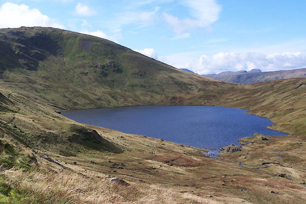
| Grisedale Tarn | ||
| locality:- | Grisedale | |
| civil parish:- | Patterdale (formerly Westmorland) | |
| county:- | Cumbria | |
| locality type:- | tarn | |
| coordinates:- | NY34891205 (etc) | |
| 1Km square:- | NY3412 | |
| 10Km square:- | NY31 | |
| altitude:- | 1769 feet | |
| altitude:- | 539m | |
|
|
||
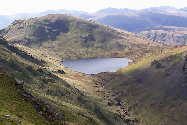 BVL36.jpg (taken 26.9.2011) 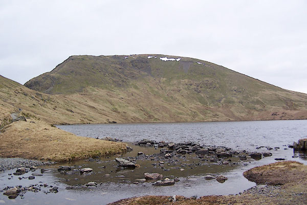 BQH17.jpg OS maps call the rocks stepping stones. (taken 17.3.2009) |
||
|
|
||
| evidence:- | old map:- Saxton 1579 |
|
| source data:- | Map, hand coloured engraving, Westmorlandiae et Cumberlandiae Comitatus ie Westmorland
and Cumberland, scale about 5 miles to 1 inch, by Christopher Saxton, London, engraved
by Augustinus Ryther, 1576, published 1579-1645.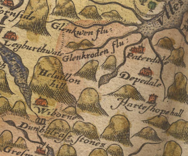 Sax9NY31.jpg Lake. item:- private collection : 2 Image © see bottom of page |
|
|
|
||
| evidence:- | old map:- Speed 1611 (Cmd) |
|
| source data:- | Map, hand coloured engraving, Cumberland and the Ancient Citie
Carlile Described, scale about 4 miles to 1 inch, by John Speed,
1610, published by J Sudbury and George Humble, Popes Head
Alley, London, 1611-12. SP11NY31.jpg outline, shaded; Westmorland item:- private collection : 16 Image © see bottom of page |
|
|
|
||
| evidence:- | probably old map:- Jansson 1646 |
|
| source data:- | Map, hand coloured engraving, Cumbria and Westmoria, ie
Cumberland and Westmorland, scale about 3.5 miles to 1 inch, by
John Jansson, Amsterdam, Netherlands, 1646.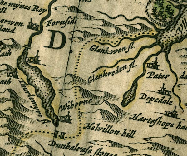 JAN3NY31.jpg Outline with shore shaded, dotted area. item:- JandMN : 88 Image © see bottom of page |
|
|
|
||
| evidence:- | old map:- Sanson 1679 |
|
| source data:- | Map, hand coloured engraving, Ancien Royaume de Northumberland
aujourdhuy Provinces de Nort, ie the Ancient Kingdom of
Northumberland or the Northern Provinces, scale about 9.5 miles
to 1 inch, by Nicholas Sanson, Paris, France, 1679. click to enlarge click to enlargeSAN2Cm.jpg outline, shore shaded; lake item:- Dove Cottage : 2007.38.15 Image © see bottom of page |
|
|
|
||
| evidence:- | old map:- Seller 1694 (Wmd) |
|
| source data:- | Map, hand coloured engraving, Westmorland, scale about 8 miles
to 1 inch, by John Seller, 1694. click to enlarge click to enlargeSEL7.jpg outline with shaded shore; lake item:- Dove Cottage : 2007.38.87 Image © see bottom of page |
|
|
|
||
| evidence:- | old map:- Morden 1695 (Cmd) |
|
| source data:- | Map, uncoloured engraving, Cumberland, scale about 4 miles to 1
inch, by Robert Morden, 1695, published by Abel Swale, the
Unicorn, St Paul's Churchyard, Awnsham, and John Churchill, the
Black Swan, Paternoster Row, London, 1695-1715.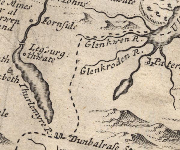 MD12NY31.jpg Outline with shore shading. item:- JandMN : 90 Image © see bottom of page |
|
|
|
||
| evidence:- | almost certainly old map:- Morden 1695 (Wmd) |
|
| source data:- | Map, hand coloured engraving, Westmorland, scale about 2.5 miles to 1 inch, by Robert
Morden, published by Abel Swale, the Unicorn, St Paul's Churchyard, Awnsham, and John
Churchill, the Black Swan, Paternoster Row, London, 1695. MD10NY41.jpg Outline with shore shading, tinted blue. item:- JandMN : 24 Image © see bottom of page |
|
|
|
||
| evidence:- | old map:- Bowen and Kitchin 1760 |
|
| source data:- | Map, hand coloured engraving, A New Map of the Counties of
Cumberland and Westmoreland Divided into their Respective Wards,
scale about 4 miles to 1 inch, by Emanuel Bowen and Thomas
Kitchin et al, published by T Bowles, Robert Sayer, and John
Bowles, London, 1760. BO18NY30.jpg outline with form lines item:- Armitt Library : 2008.14.10 Image © see bottom of page |
|
|
|
||
| evidence:- | old map:- Otley 1818 |
|
| source data:- | Map, uncoloured engraving, The District of the Lakes,
Cumberland, Westmorland, and Lancashire, scale about 4 miles to
1 inch, by Jonathan Otley, 1818, engraved by J and G Menzies,
Edinburgh, Scotland, published by Jonathan Otley, Keswick,
Cumberland, et al, 1833.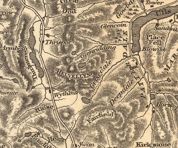 OT02NY31.jpg item:- JandMN : 48.1 Image © see bottom of page |
|
|
|
||
| evidence:- | descriptive text:- Otley 1823 (5th edn 1834) |
|
| source data:- | Guide book, A Concise Description of the English Lakes, the
mountains in their vicinity, and the roads by which they may be
visited, with remarks on the mineralogy and geology of the
district, by Jonathan Otley, published by the author, Keswick,
Cumberland now Cumbria, by J Richardson, London, and by Arthur
Foster, Kirkby Lonsdale, Cumbria, 1823; published 1823-49,
latterly as the Descriptive Guide to the English Lakes. goto source Page 34:- "... Grisedale Tarn, one of the larger class, lies in the junction of the three mountains Helvellyn, Seatsandal, and Fairfield. The road over the Hause, from Grasmere to Patterdale, passing the tarn, is accompanied by its stream down the vale of Grisedale, which unites with the parent valley near the Church. ..." |
|
|
|
||
| evidence:- | descriptive text:- Ford 1839 (3rd edn 1843) placename:- Graysdale Tarn |
|
| source data:- | Guide book, A Description of Scenery in the Lake District, by
Rev William Ford, published by Charles Thurnam, Carlisle, by W
Edwards, 12 Ave Maria Lane, Charles Tilt, Fleet Street, William
Smith, 113 Fleet Street, London, by Currie and Bowman,
Newcastle, by Bancks and Co, Manchester, by Oliver and Boyd,
Edinburgh, and by Sinclair, Dumfries, 1839. goto source Page 148:- "..." "... The stream that rushes down across the road, flows out of Graysdale Tarn, through a moist green dale, with one single house embosomed in sycamores. ..." |
|
|
|
||
| evidence:- | old map:- Ford 1839 map |
|
| source data:- | Map, uncoloured engraving, Map of the Lake District of
Cumberland, Westmoreland and Lancashire, scale about 3.5 miles
to 1 inch, published by Charles Thurnam, Carlisle, and by R
Groombridge, 5 Paternoster Row, London, 3rd edn 1843.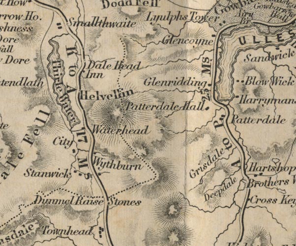 FD02NY31.jpg Outline. item:- JandMN : 100.1 Image © see bottom of page |
|
|
|
||
| evidence:- | old drawing:- Aspland 1840s-60s placename:- Grisedale Tarn |
|
| source data:- | Drawing, pencil and ink wash, near Grisedale Tarn, Patterdale, Westmorland, by Theophilus
Lindsey Aspland, 23 August 1852.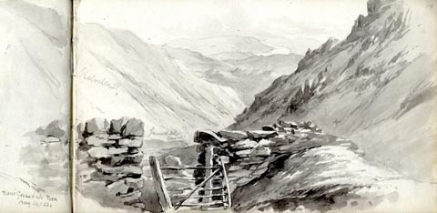 click to enlarge click to enlargeAS0320.jpg "Near Grisedale Tarn / Aug 23/52." "looking towards Ulswater? / Helvellyn? / Grisedale Tarn?" page number "15" item:- Armitt Library : 1958.390.20 Image © see bottom of page |
|
|
|
||
| evidence:- | old map:- Garnett 1850s-60s H |
|
| source data:- | Map of the English Lakes, in Cumberland, Westmorland and
Lancashire, scale about 3.5 miles to 1 inch, published by John
Garnett, Windermere, Westmorland, 1850s-60s.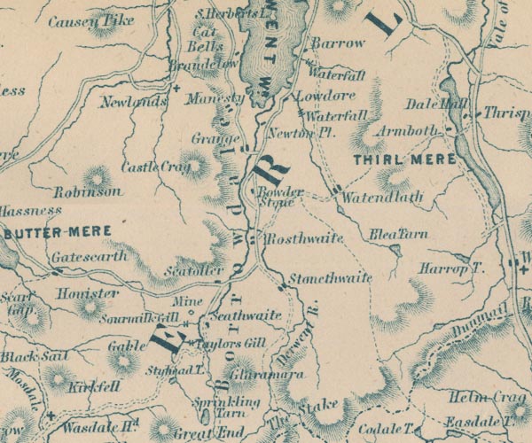 GAR2NY21.jpg outline, lake or tarn item:- JandMN : 82.1 Image © see bottom of page |
|
|
|
||
| evidence:- | old text:- Martineau 1855 |
|
| source data:- | Guide book, A Complete Guide to the English Lakes, by Harriet
Martineau, published by John Garnett, Windermere, Westmorland,
and by Whittaker and Co, London, 1855; published 1855-76. goto source Page 49:- "... Grisedale tarn, the mountain tarn of the wild boar, as the words properly signify. ..." |
|
|
|
||
| evidence:- | old photograph:- Bell 1880s-1940s |
|
| source data:- | Photograph, sepia, Fairfield, and Grisedale Tarn, Patterdale, Westmorland, by Herbert
Bell, photographer, Ambleside, Westmorland, 1890s.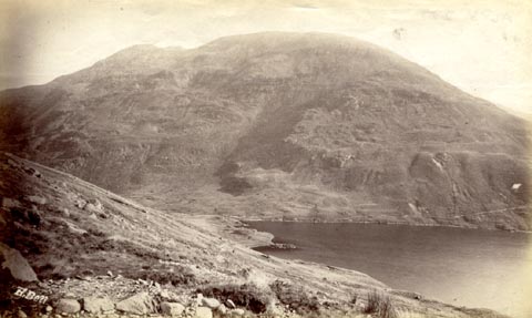 click to enlarge click to enlargeHB0567.jpg internegative at lower left:- "H. Bell" item:- Armitt Library : ALPS227 Image © see bottom of page |
|
|
|
||
| evidence:- | old print:- MacBride 1922 placename:- Grisedale Tarn |
|
| source data:- | Print, colour, Grisedale Tarn, Ullswater in the Distance, by Alfred Heaton Cooper,
published by Adam and Charles Black, 4-6 Soho Square, London, 2nd edn 1928.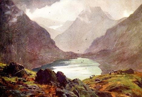 click to enlarge click to enlargeMB0115.jpg Tipped in opposite p.96 in Wild Lakeland by MacKenzie MacBride. printed at bottom:- "GRISEDALE TARN (ULLSWATER IN THE DISTANCE)" signed at lower left:- "A. HEATON COOPER" item:- JandMN : 195.17 Image © see bottom of page |
|
|
|
||
| evidence:- | old print:- Goodwin 1887 (edn 1890) placename:- Grisdale Tarn |
|
| source data:- | Print, etching? Grisdale Tarn, Patterdale, Westmorland, by Harry Goodwin, published
by Swan Sonnenschein and Co, Paternoster Square, London, 1890.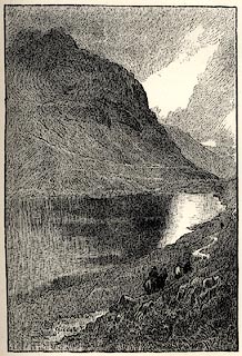 click to enlarge click to enlargePR1597.jpg Tipped in opposite p.132 of Through the Wordsworth Country, by William Knight. printed at lower left:- "Grisdale Tarn" item:- JandMN : 382.27 Image © see bottom of page |
|
|
|
||
 BVL34.jpg (taken 26.9.2011) 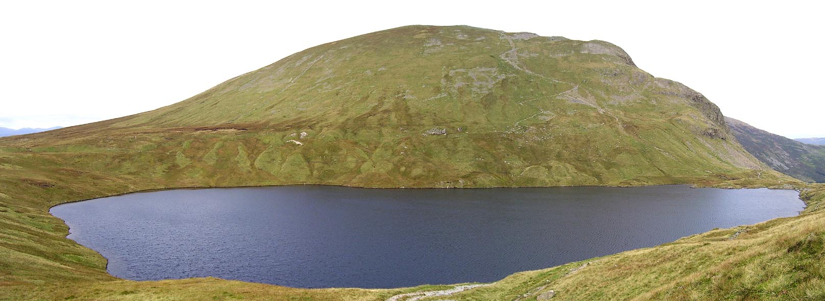 Click to enlarge BOE44.jpg (taken 11.9.2007) 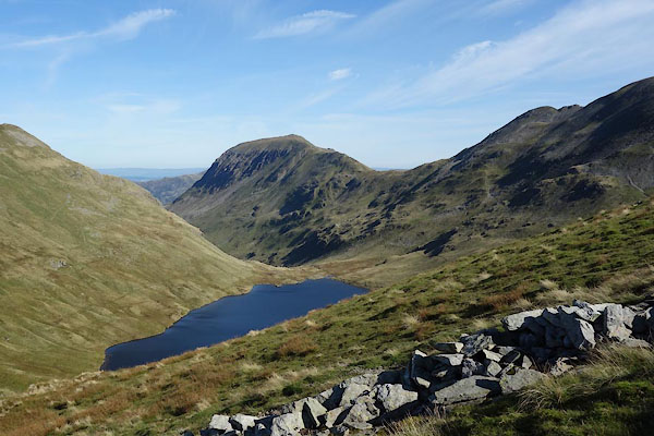 CDZ95.jpg Grisedale Tarn, St Sunday Crag, Deepdale Hause, etc (taken 28.9.2015) |
||
|
|
||
| hearsay:- |
The saxon king Edmund is said to have thrown the crown of Dunmail into the tarn after
he had defeated him in battle, 945. |
|
|
|
||
Lakes Guides menu.