 Gents Mag 1748 p.4

|

|
|
|

|
introduction | ||
|
|
list, 2nd qtr 18th century | ||
|
|
previous page next page
 |
||
|
Gentleman's Magazine 1748 p.4
principal points. For general heights to keep constantly in my eye, I fixed on three remarkable mountains, as judging they might be seen thro' the greatest part of the extent of my survey; these were Skiddow in Cumberland, Criffield, and Burnswark in Scotland, which appeared, as in the draughts. The distances were determined thus: I measured a base line on Burgh Marsh, after correcting the magnetical meridian; this was directed to a tree on an eminence near Drumbugh, as judging it the longest course in a plain. I carefully examined every angle from each of these stations, and fix'd the several places as specified in my draught. It took me up some time to get proper assistants, and fix Skiddow, one of my principal aims; the ground besides being very troublesome, by reason of the frequent creeks and quicksands, so that I could reach no farther than Bowness on the 27th at night. From the monument the coast is extremely low on the English side, and a fine pasture tillDrumbugh. At Bowness I took a new meridian to ascertian the truth of my triangles. It is properly so called from the bend of the coast at this promontory, which is the most remarkable one on the Solway bay, at least on the English side. It is to be remark'd that the river Eden has of late years kept almost close under the Scotch shore, but its course is constantly varying by the rapidity of land floods at low ebbs, thro' such a soft and slimy sand, that no chart can be given with certainty of its fesh water course; besides, the sands are extremely uncertain and dangerous to enter upon. At Fishgarth I measur'd a fresh base at low ebb, to adjust Workington light-house, and proceeded forward by Uln or Eln foot. Maps are divided how to spell this river, but it seems most reasonable Uln or Ulhn, because above Ierby, where this water flows, the dale or valley is call'd Uln dale, and the church Uln-dale church. Again from Ellenborough, near its mouth, one would be induced to write it Ellon, and 'tis commonly called at its exit Eln-foot. From Eln-foot the shore is a fine hard sand, and the coast above at some distance high and woody, particularly above Flimby, a little village with salt-pans; these woods are call'd Flimby parks, and the country assumes a better aspect. When we get to a single house call'd the Boin, the coast elbows round, and the whole track from thence to Darwent mouth is a low benty soil, so broken with rabbets, that 'tis almost impossible to ride it after night falls. The river Darwent is the second for magnitude in Cumberland; it might be made navigable to Cockermouth, by cutting thro' some grounds, and erecting locks; for it admits ships of tolerable burthen for coasters to Workington. Workington seems a town of pretty trade, above 50 vessels belong to it, and the harbour dilates above the pier, which breaks the extreme violence of tides by westerly winds, and affords a good harbour; but as it lay out of my limit I pass'd the Darwent in a boat, and proceeded to follow the course of the coast. On the opposite side we came up with the light-house and high land which we had seen for several miles; they are principal sea-marks for Workington harbour, and the Scotch coast, which appears exactly as I have drawn it.
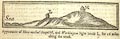 Appearance of How-michael chapel H, and Workington light house L, for 16 miles along the coast. |
|||
|
The
|
|||
|
|
next page | ||
|
gazetteer links
|
|||
|
|
-- "Bowness" -- Bowness-on-Solway | ||
|
|
-- Burgh Marsh | ||
|
|
-- (coasts, Cumbria) | ||
|
|
-- "Darwent, River" -- Derwent, River | ||
|
|
-- Drumburgh | ||
|
|
-- Eden Estuary | ||
|
|
-- "Uln, River" -- Ellen, River | ||
|
|
-- (lighthouse, Workington) | ||
|
|
-- Port of Workington | ||
|
|
-- "How Michael Chapel" -- St Michael's Chapel | ||
|
|
|||
Lakes Guides menu.