Old Cumbria Gazetteer
 |
 |
|
||
| Bowness-on-Solway | ||||
| locality:- | Hadrian's Wall | |||
| civil parish:- | Bowness (formerly Cumberland) | |||
| county:- | Cumbria | |||
| locality type:- | locality | |||
| locality type:- | buildings | |||
| locality type:- | selected place (secondary) | |||
| coordinates:- | NY22306272 (etc) | |||
| 1Km square:- | NY2262 | |||
| 10Km square:- | NY26 | |||
| latitude; longitude:- | 3d 12.8m W; 54d 57.2m N | |||
|
|
||||
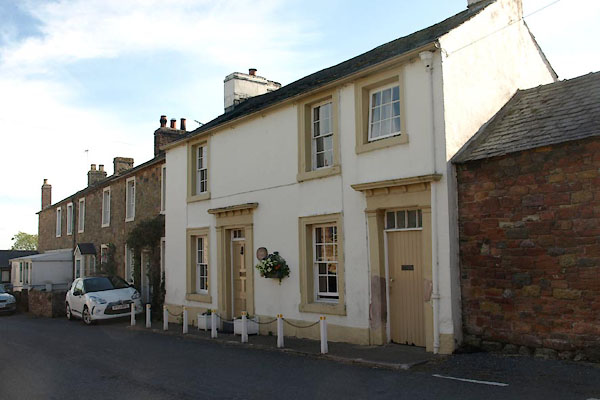
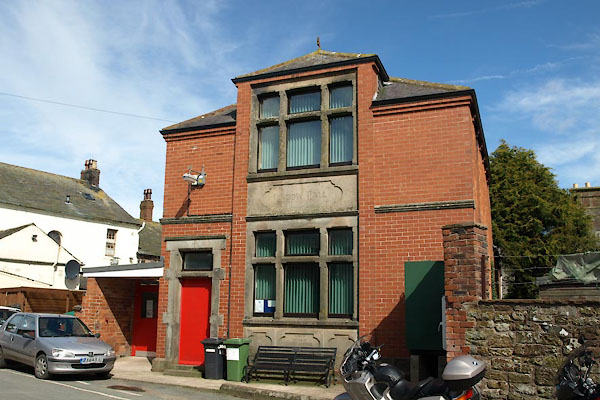
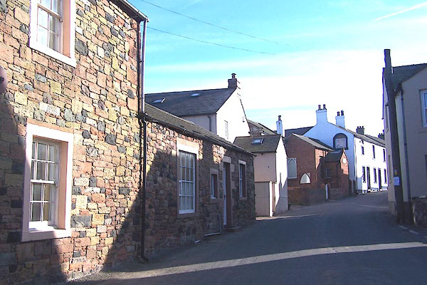 BMB15.jpg (taken 5.5.2006) |
||||
|
|
||||
| evidence:- | old map:- OS County Series (Cmd 14 4) placename:- Bowness-on-Solway |
|||
| source data:- | Maps, County Series maps of Great Britain, scales 6 and 25
inches to 1 mile, published by the Ordnance Survey, Southampton,
Hampshire, from about 1863 to 1948. |
|||
|
|
||||
| evidence:- | old map:- Gough 1350s-60s placename:- Bownes |
|||
| source data:- | Map, colour photozincograph copy, reduced size facsimile, Gough
Map of Britain, scale about 28.5 miles to 1 inch, published by
the Ordnance Survey, Southampton, Hampshire, 1875. click to enlarge click to enlargeGgh1Cm.jpg item:- JandMN : 33 Image © see bottom of page |
|||
|
|
||||
| evidence:- | old map:- Gough 1350s-60s placename:- Bownes |
|||
| source data:- | Map, lithograph facsimile, Gough Map of Britain, 20 miles to 1
inch? published by the Ordnance Survey, Southampton, Hampshire,
1935. click to enlarge click to enlargeGgh2Cm.jpg item:- JandMN : 34 Image © see bottom of page |
|||
|
|
||||
| evidence:- | old map:- Saxton 1579 placename:- Boulnesse |
|||
| source data:- | Map, hand coloured engraving, Westmorlandiae et Cumberlandiae Comitatus ie Westmorland
and Cumberland, scale about 5 miles to 1 inch, by Christopher Saxton, London, engraved
by Augustinus Ryther, 1576, published 1579-1645.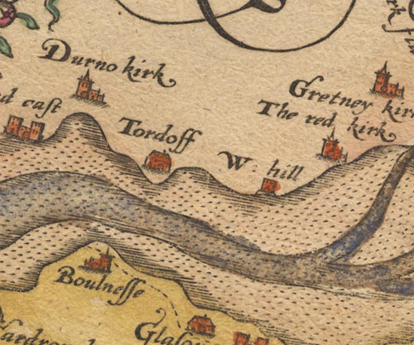 Sax9NY26.jpg Church, symbol for a parish or village, with a parish church. "Boulnesse" item:- private collection : 2 Image © see bottom of page |
|||
|
|
||||
| evidence:- | old map:- Burghley 1590 (facsimile) placename:- Bolness |
|||
| source data:- | Facsimile map, A Platt of the Opposete Border of Scotland to ye West Marches of England,
parts of Cumberland and Scotland including the Debateable Land, from a manuscript
drawn for William Cecil, Lord Burghley, about 1590, published by R B Armstrong, 1897. courtesy of the National Library of Scotland 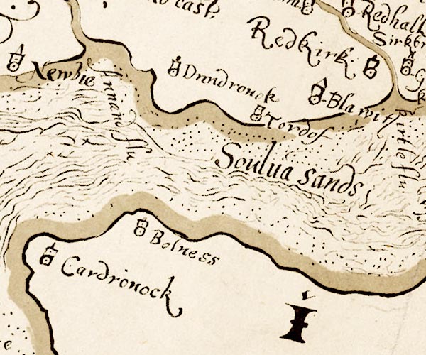 M048NY26.jpg "Bolness" circle, tower item:- National Library of Scotland : MS6113 f.267 Image © National Library of Scotland |
|||
|
|
||||
| evidence:- | old map:- Mercator 1595 (edn?) placename:- Boulness |
|||
| source data:- | Map, hand coloured engraving, Northumbria, Cumberlandia, et
Dunelmensis Episcopatus, ie Northumberland, Cumberland and
Durham etc, scale about 6.5 miles to 1 inch, by Gerard Mercator,
Duisberg, Germany, about 1595.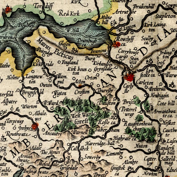 MER8CumC.jpg "Boulness" circle item:- JandMN : 169 Image © see bottom of page |
|||
|
|
||||
| evidence:- | old map:- Speed 1611 (Cmd) placename:- Boulnesse |
|||
| source data:- | Map, hand coloured engraving, Cumberland and the Ancient Citie
Carlile Described, scale about 4 miles to 1 inch, by John Speed,
1610, published by J Sudbury and George Humble, Popes Head
Alley, London, 1611-12.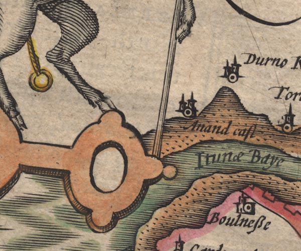 SP11NY16.jpg "Boulnesse" circle, building, tower item:- private collection : 16 Image © see bottom of page |
|||
|
|
||||
| evidence:- | poem:- Drayton 1612/1622 text placename:- Boulnesse |
|||
| source data:- | Poem, Poly Olbion, by Michael Drayton, published by published by
John Marriott, John Grismand and Thomas Dewe, and others?
London, part 1 1612, part 2 1622. goto source goto sourcepage 167:- "... Severus wall, Of that great Emperour nam'd, which first that worke began, ... doth end At Boulnesse, where my selfe [Eden] I on the Ocean spend." |
|||
|
|
||||
| evidence:- | probably table of distances:- Simons 1635 placename:- Boulness |
|||
| source data:- | Table of distances, uncoloured engraving, Cumberland, with a
thumbnail map, scale about 41 miles to 1 inch, by Mathew Simons,
published in A Direction for the English Traviller, 1635.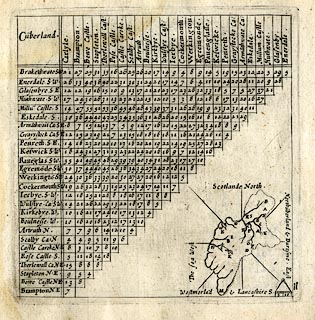 click to enlarge click to enlargeSIM4.jpg "Boulness W" and tabulated distances item:- private collection : 50.11 Image © see bottom of page |
|||
|
|
||||
| evidence:- | old map:- Jansson 1646 placename:- Boulnesse |
|||
| source data:- | Map, hand coloured engraving, Cumbria and Westmoria, ie
Cumberland and Westmorland, scale about 3.5 miles to 1 inch, by
John Jansson, Amsterdam, Netherlands, 1646.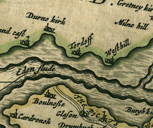 JAN3NY26.jpg "Boulnesse" Buildings and tower. item:- JandMN : 88 Image © see bottom of page |
|||
|
|
||||
| evidence:- | old map:- Sanson 1679 placename:- Boulnesse |
|||
| source data:- | Map, hand coloured engraving, Ancien Royaume de Northumberland
aujourdhuy Provinces de Nort, ie the Ancient Kingdom of
Northumberland or the Northern Provinces, scale about 9.5 miles
to 1 inch, by Nicholas Sanson, Paris, France, 1679. click to enlarge click to enlargeSAN2Cm.jpg "Boulnesse" circle, building and tower, flag; town? item:- Dove Cottage : 2007.38.15 Image © see bottom of page |
|||
|
|
||||
| evidence:- | possibly old map:- Morden 1695 (EW) placename:- Bonhiess |
|||
| source data:- | Map, hand coloured engraving, England, including Wales, scale
about 27 miles to 1 inch, by Robert Morden, published by Abel
Swale Awnsham and John Churchil, London, about 1695. click to enlarge click to enlargeMRD3Cm.jpg "Bon[h]iess" labelled in Solway Firth item:- JandMN : 339 Image © see bottom of page |
|||
|
|
||||
| evidence:- | old map:- Morden 1695 (Cmd) placename:- Boulness |
|||
| source data:- | Map, uncoloured engraving, Cumberland, scale about 4 miles to 1
inch, by Robert Morden, 1695, published by Abel Swale, the
Unicorn, St Paul's Churchyard, Awnsham, and John Churchill, the
Black Swan, Paternoster Row, London, 1695-1715.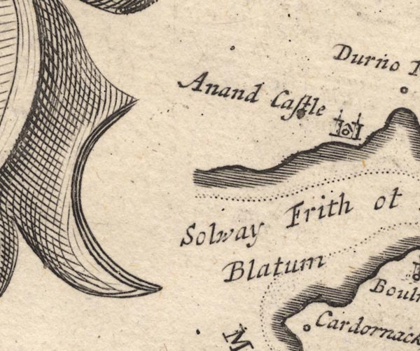 MD12NY16.jpg 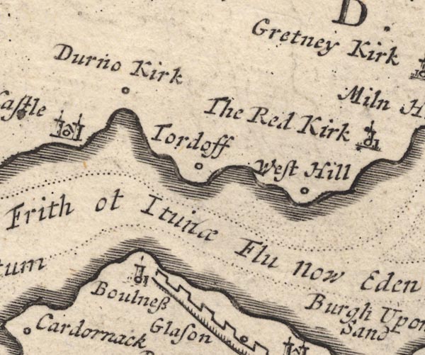 MD12NY26.jpg "Boulness / Blatum" Circle, building and tower. item:- JandMN : 90 Image © see bottom of page |
|||
|
|
||||
| evidence:- | old map, descriptive text:- Bowen 1720 (plate 162) placename:- Bolness placename:- Blatum Bulgium |
|||
| source data:- | Road book, Britannia Depicta Or Ogilby Improv'd, including road
strip maps with sections in Westmorland and Cumberland, scale
about 2 miles to 1 inch, derived from maps by Ogilby, 1675, also
a county map of Westmorland, scale about 8 miles to 1 inch, and
of Cumberland, scale about 16.5 miles to 1 inch, each with text,
by John Owen, published by Emanuel Bowen, London, 1720;
published 1720-64. "... on a Cape of Land is Bolness the Old Blatum Bulgiu~, formerly a Roman Station, now a little Village, having the conveniency of a Harbour & a Fort for its defence, it being the utmost bound between England, & Scotland, as the British Word Bulch signifies: ..." |
|||
|
|
||||
| evidence:- | old text:- Gents Mag placename:- Bowness item:- surveying; triangulation |
|||
| source data:- | Magazine, The Gentleman's Magazine or Monthly Intelligencer or
Historical Chronicle, published by Edward Cave under the
pseudonym Sylvanus Urban, and by other publishers, London,
monthly from 1731 to 1922. goto source Gentleman's Magazine 1748 p.4 "..." "At Bowness I took a new meridian to ascertian the truth of my triangles. It is properly so called from the bend of the coast at this promontory, which is the most remarkable one on the Solway bay, at least on the English side. ..." |
|||
|
|
||||
| evidence:- | descriptive text:- Simpson 1746 placename:- Bulness placename:- Blatum Bulgium item:- Antonine Itineraries |
|||
| source data:- | Atlas, three volumes of maps and descriptive text published as
'The Agreeable Historian, or the Compleat English Traveller
...', by Samuel Simpson, 1746. goto source "..." "Bulnesse which was the old Town, called by the Romans, Blatum Bulgium probably from the British Word Bulch, which signifies Partition or Divorce; or rather from a Word still in use in those Parts viz. Bulge, which signifies a Breaking in, as the Sea there doth. From this Place, as the utmost Limits of the Province of Britain, Antoninus begins his Itinerary. It is now but a very small Village, but has a Fort, as a Testimony of its Antiquity, besides the Tracts of Streets and Pieces of old Walls, which frequently appear as they are ploughing in the common Field." "It was anciently the Head Town of a large Manor containing many Hamlets, as Glaston, Drumburgh, &c. and tho' many of which are separated from it, yet here still remains the Mother Church. At a Mile's Distance from hence Northward, begins the famous Picts Wall: ..." |
|||
|
|
||||
| evidence:- | old map:- Bowen and Kitchin 1760 placename:- Boulness |
|||
| source data:- | Map, hand coloured engraving, A New Map of the Counties of
Cumberland and Westmoreland Divided into their Respective Wards,
scale about 4 miles to 1 inch, by Emanuel Bowen and Thomas
Kitchin et al, published by T Bowles, Robert Sayer, and John
Bowles, London, 1760.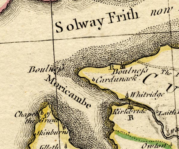 BO18NY15.jpg "Boulness / R" circle, building and tower, rectory item:- Armitt Library : 2008.14.10 Image © see bottom of page |
|||
|
|
||||
| evidence:- | old map:- Donald 1774 (Cmd) placename:- Bowness |
|||
| source data:- | Map, hand coloured engraving, 3x2 sheets, The County of Cumberland, scale about 1
inch to 1 mile, by Thomas Donald, engraved and published by Joseph Hodskinson, 29
Arundel Street, Strand, London, 1774.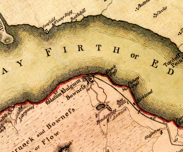 D4NY26SW.jpg "Bowness" blocks, labelled in upright lowercase; a village, street plan with blocks and a house item:- Carlisle Library : Map 2 Image © Carlisle Library |
|||
|
|
||||
| evidence:- | old map:- Donald 1774 (Cmd) placename:- Bowness |
|||
| source data:- | Map, hand coloured engraving, 3x2 sheets, The County of Cumberland, scale about 1
inch to 1 mile, by Thomas Donald, engraved and published by Joseph Hodskinson, 29
Arundel Street, Strand, London, 1774.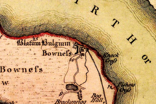 DN04BwSl.jpg "Bowness" blocks, labelled in upright lowercase; a village, street plan with blocks and a house item:- Carlisle Library : Map 2 Image © Carlisle Library |
|||
|
|
||||
| evidence:- | old text:- Camden 1789 placename:- Bulnesse placename:- Blatum Bulgium item:- placename, Bowness-on-Solway |
|||
| source data:- | Book, Britannia, or A Chorographical Description of the Flourishing Kingdoms of England,
Scotland, and Ireland, by William Camden, 1586, translated from the 1607 Latin edition
by Richard Gough, published London, 1789. goto source Page 173:- "... On this little cape stands that antient town BLATUM BULGIUM (perhaps from the British word Bulch which signifies separation or division), from which Antoninus as from the furthest point and boundary of the province begins his Itinera through Britain. The inhabitants now call it Bulnesse, and it is a very mean village, though it has fortification, and as evidences of antiquity, besides traces of streets and ruined walls, a harbour filled up, and a road said to have run hence along the coast to Elenborrow. ..." |
|||
|
|
||||
| evidence:- | old text:- Camden 1789 (Gough Additions) placename:- Boulness placename:- Bolness |
|||
| source data:- | Book, Britannia, or A Chorographical Description of the Flourishing Kingdoms of England,
Scotland, and Ireland, by William Camden, 1586, translated from the 1607 Latin edition
by Richard Gough, published London, 1789. goto source Page 187:- "..." ""Bolnes is at the poynt or playne of the river of Edon, where is a little poor steple as a fortelet for a brunt, and it is on the higher side of the river of Edon, about a eight miles from Cair Luel. About this Bolnesse is part of the Pict wal evidently remaining, and it may be supposed that it is called Bolnes, as who should say the Wal Yee, or poynt, or end."" "Mr. Routh in a letter to Mr. Gale, dated Nov. 1, 1741, says, "the altar at Boulness was found about two years and a half ago in some adjacent grounds belonging to one Mr. Lawson, who placed it over a barn door fronting the street where it now remains. There seems to be an oblique stroke under the P. in posuit, which has occasioned all the copies I have seen to give it PROSUIT, but the late marks of masons' tools on it will account for that. The H in COH is scarce legible, nor could I perceive the least signs of numerals after it, though there is room enough. The altar may be about 18 inches high, and 12 broad: the letters much worn, but of the Lower Empire cut." The following copy of it was taken 1739 for sir John Clerk by the schoolmaster of the place on a ladder 16 feet high, it being then built up in a new chapel belonging to Mr. Lawson." "I. O. M. PRO SALVTE D. D. N. N. GALLI ET VOLVSIANI AVGG SVLICIVS SECVNDINVS US. TRIB CO R. POSVIT." "... Mr. Gilpin gave the Society of Antiquaries, 1740, an account of this altar then built up in Mr. Lawson's barn at Carlisle." |
|||
|
|
||||
| evidence:- | old text:- Camden 1789 (Gough Additions) placename:- Boulness |
|||
| source data:- | Book, Britannia, or A Chorographical Description of the Flourishing Kingdoms of England,
Scotland, and Ireland, by William Camden, 1586, translated from the 1607 Latin edition
by Richard Gough, published London, 1789. goto source Page 229, quoting Mr Horsley:- "..." ""At BOULNESS, ... The village now stands, and the fort has stood, upon a rock or promontory, on the edge of Solway frith; and it is not to be doubted but the church, and what other stone buildings are in the village, have been raised out of its ruins." ""The station must have supplied them sufficiently with what stones they have used in their houses, most of which are made of clay; so that they have not gone to any distance to fetch stones from the wall, ..."" |
|||
|
|
||||
| evidence:- | road book:- Cary 1798 (2nd edn 1802) placename:- Bowness |
|||
| source data:- | Road book, itineraries, Cary's New Itinerary, by John Cary, 181
Strand, London, 2nd edn 1802. goto source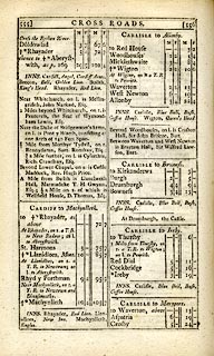 click to enlarge click to enlargeC38555.jpg page 555-556 "Bowness" item:- JandMN : 228.2 Image © see bottom of page |
|||
|
|
||||
| evidence:- | old map:- Laurie and Whittle 1806 placename:- Bowness |
|||
| source data:- | Road map, Completion of the Roads to the Lakes, scale about 10
miles to 1 inch, by Nathaniel Coltman? 1806, published by Robert
H Laurie, 53 Fleet Street, London, 1834. click to enlarge click to enlargeLw18.jpg "Bowness 318¾" village or other place; distance from London item:- private collection : 18.18 Image © see bottom of page |
|||
|
|
||||
| evidence:- | old text:- Capper 1808 placename:- Bowness item:- population |
|||
| source data:- | Gazetteer, A Topographical Dictionary of the United Kingdom,
compiled by Benjamin Pitts Capper, published by Richard
Phillips, Bridge Street, Blackfriars, London, 1808; published
1808-29. goto source "..." "BOWNESS, a parish in Cumberland ward, Cumberland, situated on the Solway Firth, 10 miles from Carlisle, and 314 from London; containing 49 houses and 220 inhabitants. The living is a rectory, value 21l. 13s. 11d." "..." |
|||
|
|
||||
| evidence:- | old map:- Cooper 1808 placename:- Bowness |
|||
| source data:- | Map, uncoloured engraving, Cumberland, scale about 10.5 miles to
1 inch, drawn and engraved by Cooper, published by R Phillips,
Bridge Street, Blackfriars, London, 1808. click to enlarge click to enlargeCOP3.jpg "Bowness" circle; village or hamlet item:- JandMN : 86 Image © see bottom of page |
|||
|
|
||||
| evidence:- | old map:- Hall 1820 (Cmd) placename:- Bowness |
|||
| source data:- | Map, hand coloured engraving, Cumberland, scale about 21 miles
to 1 inch, engraved by Sidney Hall, published by S Leigh, 18
Strand, London, 1820-31. click to enlarge click to enlargeHA14.jpg "Bowness" circle, italic lowercase text; settlement item:- JandMN : 91 Image © see bottom of page |
|||
|
|
||||
| evidence:- | old map:- Ford 1839 map placename:- Bowness |
|||
| source data:- | Map, uncoloured engraving, Map of the Lake District of
Cumberland, Westmoreland and Lancashire, scale about 3.5 miles
to 1 inch, published by Charles Thurnam, Carlisle, and by R
Groombridge, 5 Paternoster Row, London, 3rd edn 1843.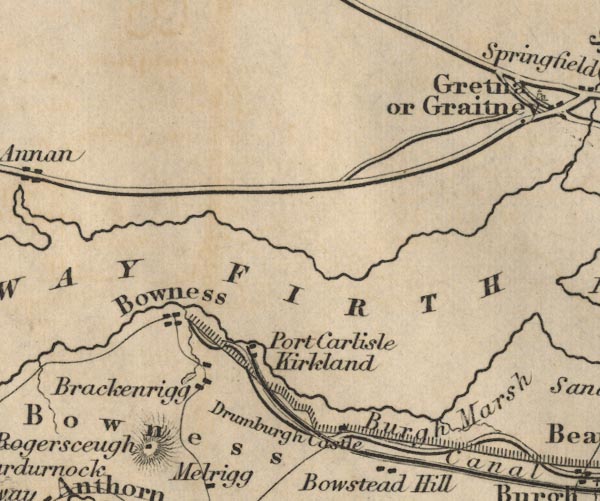 FD02NY26.jpg "Bowness" item:- JandMN : 100.1 Image © see bottom of page |
|||
|
|
||||
| evidence:- | old map:- Garnett 1850s-60s H |
|||
| source data:- | Map of the English Lakes, in Cumberland, Westmorland and
Lancashire, scale about 3.5 miles to 1 inch, published by John
Garnett, Windermere, Westmorland, 1850s-60s. GAR2NY26.jpg blocks, settlement item:- JandMN : 82.1 Image © see bottom of page |
|||
|
|
||||
| evidence:- | old map:- Post Office 1850s-1900s placename:- Bowness |
|||
| source data:- | Post road maps, General Post Office Circulation Map for England
and Wales, for the General Post Office, London, 1850s-1900s. click to enlarge click to enlargePOF7Cm.jpg "Bowness" map date 1909 |
|||
|
|
||||
| evidence:- | old map:- Post Office 1850s-1900s placename:- Bowness |
|||
| source data:- | Post road maps, General Post Office Circulation Map for England
and Wales, for the General Post Office, London, 1850s-1900s. click to enlarge click to enlargePF10Cm.jpg "Bowness" map date 1892 |
|||
|
|
||||
| evidence:- | old map:- Post Office 1850s-1900s placename:- Bowness |
|||
| source data:- | Post road maps, General Post Office Circulation Map for England
and Wales, for the General Post Office, London, 1850s-1900s. click to enlarge click to enlargePOF2Cm.jpg "Bowness" map date 1890 |
|||
|
|
||||
| evidence:- | old map:- Post Office 1850s-1900s placename:- Bowness |
|||
| source data:- | Post road maps, General Post Office Circulation Map for England
and Wales, for the General Post Office, London, 1850s-1900s. click to enlarge click to enlargePOF8Cm.jpg "Bowness" map date 1873 |
|||
|
|
||||
| :- |
images courtesy of the British Postal Museum and Hampshire CC Museums |
|||
|
|
||||
| places:- |
|
|||
|
||||
|
||||
|
||||
|
||||
|
||||
|
||||
|
||||
|
||||
|
||||
|
||||
|
||||
|
||||
|
||||
|
||||
|
||||
|
||||
|
||||
|
||||
|
||||
|
||||
|
||||
Lakes Guides menu.