 Old Cumbria Gazetteer
 |
 |
|
| Port of Workington, Workington | ||
| Port of Workington | ||
| Workington Harbour | ||
| site name:- | Derwent, River | |
| locality:- | Workington | |
| civil parish:- | Workington (formerly Cumberland) | |
| county:- | Cumbria | |
| locality type:- | harbour | |
| coordinates:- | NX991293 (etc) | |
| 1Km square:- | NX9929 | |
| 10Km square:- | NX92 | |
|
|
||
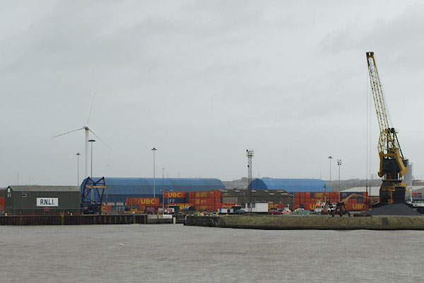 BTT21.jpg (taken 5.11.2010) 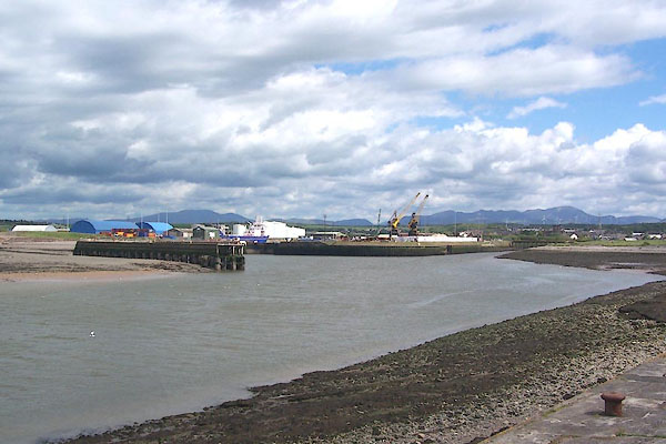 BNQ78.jpg (taken 14.5.2007) |
||
|
|
||
| evidence:- | old map:- Jansson 1646 placename:- Derwenfote Haven |
|
| source data:- | Map, hand coloured engraving, Cumbria and Westmoria, ie
Cumberland and Westmorland, scale about 3.5 miles to 1 inch, by
John Jansson, Amsterdam, Netherlands, 1646.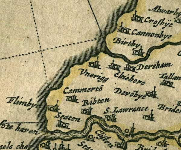 JAN3NY03.jpg "Derwenfote haven" Label at the Derwent mouth. item:- JandMN : 88 Image © see bottom of page |
|
|
|
||
| evidence:- | old map:- Morden 1695 (Cmd) placename:- Derwentfoot Haven |
|
| source data:- | Map, uncoloured engraving, Cumberland, scale about 4 miles to 1
inch, by Robert Morden, 1695, published by Abel Swale, the
Unicorn, St Paul's Churchyard, Awnsham, and John Churchill, the
Black Swan, Paternoster Row, London, 1695-1715.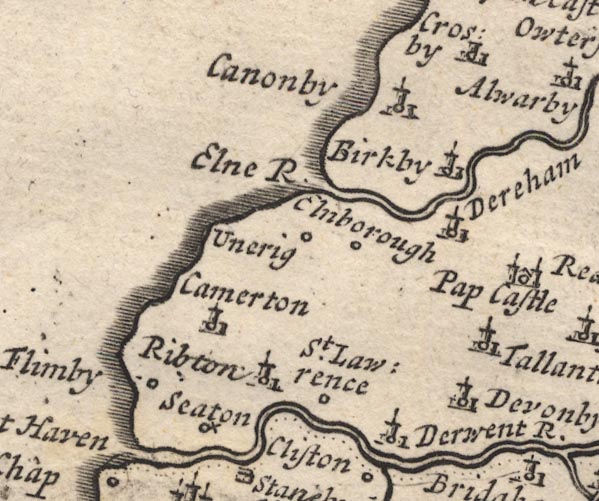 MD12NY03.jpg "Derwentfoot Haven" River mouth. item:- JandMN : 90 Image © see bottom of page |
|
|
|
||
| evidence:- | old text:- Gents Mag |
|
| source data:- | Magazine, The Gentleman's Magazine or Monthly Intelligencer or
Historical Chronicle, published by Edward Cave under the
pseudonym Sylvanus Urban, and by other publishers, London,
monthly from 1731 to 1922. goto source goto sourceGentleman's Magazine 1748 p.4 "... Workington seems a town of pretty trade, above 50 vessels belong to it, and the harbour dilates above the pier, which breaks the extreme violence of tides by westerly winds, and affords a good harbour; ..." |
|
|
|
||
| evidence:- | old map:- Donald 1774 (Cmd) |
|
| source data:- | Map, hand coloured engraving, 3x2 sheets, The County of Cumberland, scale about 1
inch to 1 mile, by Thomas Donald, engraved and published by Joseph Hodskinson, 29
Arundel Street, Strand, London, 1774.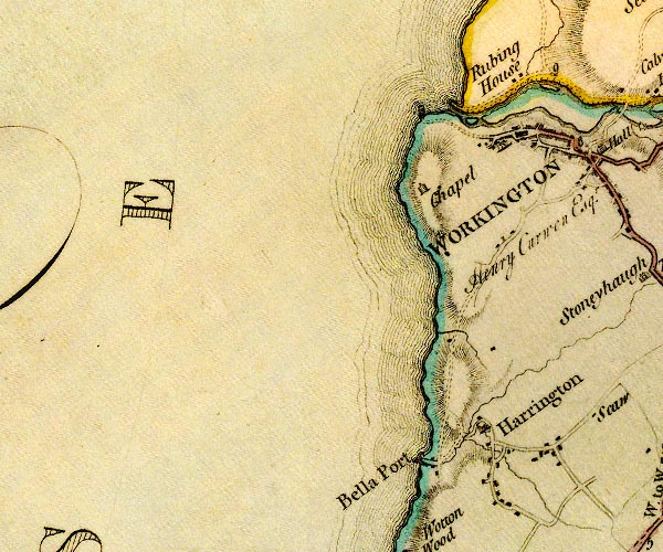 D4NX92NE.jpg harbour moles? item:- Carlisle Library : Map 2 Image © Carlisle Library |
|
|
|
||
| evidence:- | old text:- Mackenzie 1776 placename:- Workington Harbour item:- harbour light |
|
| source data:- | Charts, and sailing directions, Nautical Descriptions of the
West Coast of Great Britain, Bristol Channel to Cape Wrath, by
Murdoch Mackenzie, published London, 1776. goto source Pages 23-24:- "... ..." "WORKINGTON Harbour." "In Workington Harbour there is thirteen feet at high-water with ordinary spring-tides, and seven or eight with neap-tides. When there are eight feet of water in this Harbour, colours are hoisted in the day, and a lighted lanthorn hung by a rope at night, on the starboard hand goning in, about two ships-length from the channel. To sail into Workington Harbour; keep about two cables-length from the edge of the sea, until the lanthorn bears about S.E. then steer right for it; from thence steer E. into the Harbour." "Workington distinguished at Sea. / Workington may be distinguished at sea by How-michael Hill, which has a small tower on the top of it, and stands about half a mile south-westward of the Harbour's-mouth." "There was a proposal some years ago for deepening the water in the entry of this harbour, and making it more commodious to sail out of it than it was with certain winds then; by extending the pier-head eastward, and the basket-work on the E. side of the entry, north-westward. I have not yet learned whether this has been carried into execution." |
|
|
|
||
| evidence:- | old text:- Camden 1789 (Gough Additions) |
|
| source data:- | Book, Britannia, or A Chorographical Description of the Flourishing Kingdoms of England,
Scotland, and Ireland, by William Camden, 1586, translated from the 1607 Latin edition
by Richard Gough, published London, 1789. goto source Page 184:- "..." ""On the west side of Darwent is a pretty creke, whereas shyppes come to where ys a pretty litle fisher town called Wyrkenton, ..."" |
|
|
|
||
| evidence:- | old text:- Capper 1808 |
|
| source data:- | Gazetteer, A Topographical Dictionary of the United Kingdom,
compiled by Benjamin Pitts Capper, published by Richard
Phillips, Bridge Street, Blackfriars, London, 1808; published
1808-29. goto source "[Workington] ... a sea port, ... there being upwards of 100 vessels employed in the coal trade to and from this port; ..." |
|
|
|
||
| evidence:- | descriptive text:- Ford 1839 (3rd edn 1843) |
|
| source data:- | Guide book, A Description of Scenery in the Lake District, by
Rev William Ford, published by Charles Thurnam, Carlisle, by W
Edwards, 12 Ave Maria Lane, Charles Tilt, Fleet Street, William
Smith, 113 Fleet Street, London, by Currie and Bowman,
Newcastle, by Bancks and Co, Manchester, by Oliver and Boyd,
Edinburgh, and by Sinclair, Dumfries, 1839. goto source Page 173:- "[Workington] ... has a good harbour, and an extensive trade in coal, from the valuable collieries of Henry Curwen, Esq., and several other collieries, many of which are at a considerable distance." |
|
|
|
||
| evidence:- | old map:- Walker 1842 |
|
| source data:- | Chart, Position of all the Lighthouses in the British Isles,
scale about 38 nautical miles to 1 inch, published by J and A
Walker, 72 South Castle Street, Liverpool, Lancashire, 1842. marked with a harbour light "Workington - Two Lights - shewn only whilst there is 8 feet depth in the Harbour" |
|
|
|
||
| evidence:- | old map:- Garnett 1850s-60s H |
|
| source data:- | Map of the English Lakes, in Cumberland, Westmorland and
Lancashire, scale about 3.5 miles to 1 inch, published by John
Garnett, Windermere, Westmorland, 1850s-60s.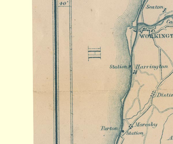 GAR2NX92.jpg estuary of the Derwent item:- JandMN : 82.1 Image © see bottom of page |
|
|
|
||
| evidence:- | old text:- Admiralty 1933 placename:- item:- pilot, Port of Workington |
|
| source data:- | goto source Page 387:- "..." "FIRTH OF SOLWAY. - ..." "Whitehaven, Workington, Maryport and Silloth, all on the English shore, are the chief trading ports in the firth." goto sourcePage 388:- "..." "Pilots. - There are Trinity House pilots for Whitehaven, Workington, and Maryport, the pilot cutter, which does not cruise, being stationed at Whitehaven; vessels requiring pilots for any of these places can obtain them off Whitehaven, or may proceed to a point off their destination." "The signal to be made during foggy weather by a vessel requiring a pilot is three long blasts; the reply is one long and two short blasts." |
|
|
|
||
| evidence:- | old text:- Admiralty 1933 placename:- Port of Workington item:- leading line; navigation lights; fog signals; beacons; dredger; ironworks; coal; cranes; railways; water; hospital; rails; pig iron; grain; timber; iron ore |
|
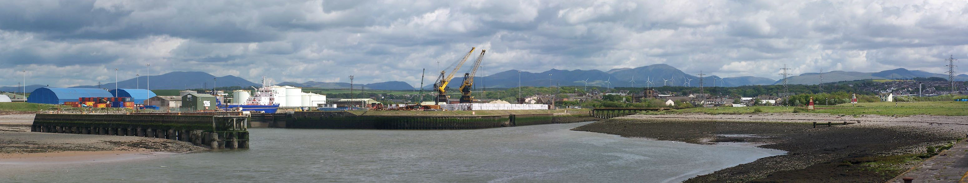
| source data:- | goto source Page 393:- "..." "WORKINGTON. - Depths. - The port of Workington is situated at the mouth of the River Derwent, about 6 miles northward of Whitehaven, and consists of a tidal harbour and a wet dock, known as Prince of Wales dock." "The entrance to the port is protected by South Pier, a concrete pier which extends about 1,00 feet (304m8) seaward, in a north-westerly direction, from a point on the southern side of the entrance to the river." "North jetty projects 600 feet (182m9), in a north-westerly, and then about 400 feet (121m9), in a south-westerly direction, from the northern side of the entrance to the river, and forms what is known as Turning basin; depths of 4 1/2 feet (1m4) are maintained in this basin and in the channel in the approach to it." "Tidal dock and Tidal harbour (Lat. 54~ 39' N., Long. 3~ 34' W.) are situated on the southern side of the entrance to the river." "Tidal harbour is entered through a swing bridge with depths of 20 feet (6m1) in the passage, which is 50 feet (15m2) wide, at high water springs; there are 2,800 feet (853m4) of quayage, with depths of from 15 to 20 feet (4m6 to 6m1) alongside at high water springs, in Tidal dock and Tidal harbour." "Prince of Wales dock. - Prince of Wales dock is entered, from Turning basin, through a gateway 70 feet (21m3) wide with depths of 4 1/2 feet (1m4) over the sill. It has 2,800 feet (853m4) of quayage, with depths of 33 1/2 feet (10m2) alongside at high water springs. Depths of 22 feet (6m7) are normally maintained in the dock." "The dock gates are usually open for 3 1/2 hours before until 2 hours after high water, but the gates are closed in time to retain sufficient depths to float the vessel of the deepest draught in the dock at the time." "Lights. - Beacons. - Fog signal. - A light is exhibited, at an elevation of 35 feet (10m7), from a grey, steel, framework structure, 20 feet (6m1) in height, situated at the outer end of South pier. A fog signal is sounded from this position." "A light is exhibited from a perch situated at the root of South pier." "A light is exhibited, at an elevation of 22 feet (6m7), from an iron column, 12 feet (3m7) in height, situated on the outer end of North jetty." "A light is exhibited from the coal conveyor at the north-western end of Riverside wharf." "Two white pyramidal beacons are situated in the shipyard on the southern side of the channel. These beacons, when in line, lead in the deepest channel from the sea until abreast the seaward" |
|
| source data:- | goto source Page 394:- "end of North jetty. Lights are exhibited, at elevations of 50 and 60 feet (15m2 and 18m3), respectively, from these beacons." "Lights are exhibited from two perches situated on the northern side of the entrance channel; these perches are for the use of dredgers." "Caution. - It is difficult to distinguish these lights, at times, owing to the number of blast furnaces in the neighbourhood." "Signals. - A black ball is displayed by day, or one red light at night, on the mast at the north-western end of Prince of Wales dock (Lat. 54~ 39' N., Long. 3~ 34' W.), from 2 1/2 hours before until 2 1/2 hours after high water when there are depths of not less than 15 feet (4m6) in the entrance channel." "Two black balls by day, or two red lights at night, shown in the same position as the tidal signal, indicate that the entrance channel is blocked and that no vessel should attempt to enter." "The dredger or dredgers, when working in the entrance channel or in the harbour, will show the following signals, which must be strictly complied with:-" "By day: One red flag on the side on which vessels must pass." "At night: Three white lights in the form of a triangle on top of the dredger's tower with an addition white light on the side on which vessels must pass." "Pilots. - Tugs. - For information regarding pilots see page 388." "One or more steam-tugs belong to the harbour. The signal for a tug is the ensign hoisted at the main masthead, by day, or four blasts on the siren or steam whistle, at night." "If the steam-tug be disabled or cannot get out, on the usual signal being made, a red flag is shown by day, or a small red light, at night, from a position near the signal staff." "Port facilities. - There are extensive coal mines in the neighbourhood and supplies of coal can be put on board, either in the dock or in the harbour. The dock is equipped with six 5-ton electric cranes, one 15-ton steam crane and two electrically operated belt conveyors, each capable of loading 800 tons of coal an hour. The tidal harbour is equipped with five 3-ton steam cranes. All the principal quays are connected with the mainline railway system." "An ample supply of fresh water is available in the dock and in the harbour." "There is an infirmary, and a hospital for infectious cases." "Shipping. - Trade. - During the year 1932, a total number of 23 vessels, with an aggregate tonnage of 132,031 tons, visited the port from foreign and colonial ports, and 824 vessels, with an aggregate tonnage of 315,517 tons, coastwise." "Large ironworks furnish the chief portion of the export trade, which consists mainly in rails, pig and bar iron, steel sleepers, and plates; the imports are grain, timber, ore, &c." "Town. - Workington, which in 1931 had a population of 24,691, is situated on the southern side of the mouth of the River Derwent. A portion of the town is little above the level of the harbour, but the principal part is on an eminence." "A swing bridge crosses the entrance to the tidal harbour, and, immediately north-eastwards of the swing bridge, the railway bridge crosses the mouth of the River Derwent." |
|
| source data:- | goto source Page 395:- "" "Life-saving. - A look-out is kept for life-saving purposes, and a rocket apparatus is maintained here." "Storm signals. - Storm signals are shown by day and at night from a flagstaff on Main pier, on the south-western side of the entrance to Tidal harbour (Lat. 54~ 39' N., Long. 3~ 34' W.)." "River Derwent. - The Derwent rises among the mountains at the head of Borrowdale, 1 1/4 miles north-eastward of Scafell Pikes, 3,210 feet (978m4) high. It joins Derwentwater 7 1/2 miles from its source, issues from the northern end of that lake near Keswick, and is there joined by the Greta; it then winds through a marshy plain, at the south-western foot of Skiddaw, for 3 miles, and enters Lake Bassenthwaite, which is 3 1/2 miles long; from thence it flows on by Cockermouth, Great Broughton, and Camerton, to Workington, where, at half a mile below the bridge, it falls into the sea; its total length, including 2 3/4 miles through Derwentwater, being 36 miles; its outlet forms Workington harbour." |
|
|
|
||
 old shipping directory old shipping directory |
||
|
|
||
| evidence:- | old print:- item:- ship; staith; tramroad |
|
| source data:- | Print, uncoloured engraving, Workington, Cumberland, drawn by W H Bartlett, engraved
by R Wallis, published 1840s.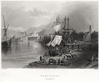 click to enlarge click to enlargePR0078.jpg Probably from Findens Views of the Ports, Harbours, Coast Scenery, and Watering Places of Great Britain, as continued by W H Bartlett. printed at bottom left, right, centre:- "W. H. Bartlett. / R. Wallis. / WORKINGTON. / (Cumberland.)" item:- Dove Cottage : 2008.107.78 Image © see bottom of page |
|
|
|
||
| evidence:- | text:- |
|
| source data:- | Rules, printed sheet, Abstract of Rules and Laws for Workington
Harbour, or Port of Workington, Cumberland, published by the
trustees 24 March 1791.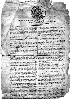 click to enlarge click to enlargePR1551.jpg Rules, printed sheet, Abstract of Rules and Laws for Workington Harbour, or Port of Workington, Cumberland, published by the trustees, 24 March 1791. printed at top:- "ABSTRACT of RULES and LAWS For WORKINGTON HARBOUR ..." courtesy of Alan Taylor item:- private collection : 228 Image © see bottom of page |
|
|
|
||
 Click to enlarge BNQ79.jpg (taken 14.5.2007) 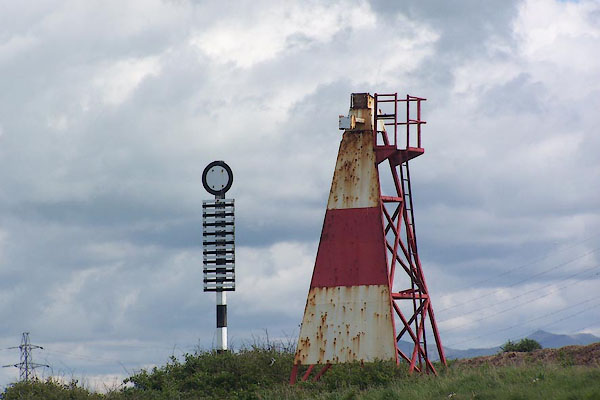 BNQ80.jpg Sea marks for the harbour channel. (taken 14.5.2007) 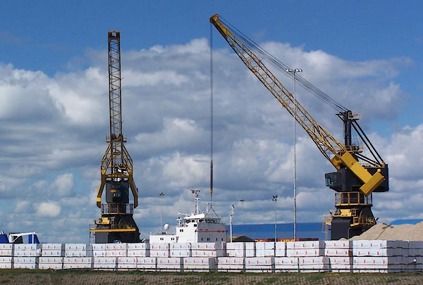 BNQ95.jpg Cranes. (taken 14.5.2007) 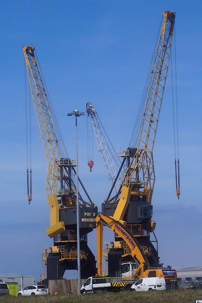 CGB29.jpg Cranes. (taken 10.5.2017) 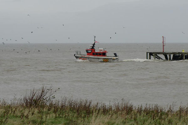 BTT20.jpg EON workboat going out to Robin Rigg Windfarm (taken 5.11.2010) |
||
|
|
||
| MN photo:- |
Old building, some sort of port office? on the road out to the John Pier. |
|
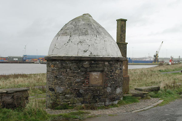 BTT22.jpg (taken 5.11.2010) 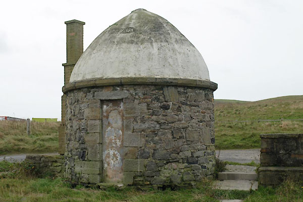 BTT23.jpg (taken 5.11.2010) |
||
|
|
||
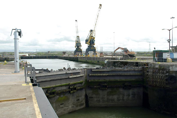 BUN96.jpg Dock gates, Prince of Wales Dock. (taken 13.5.2011) 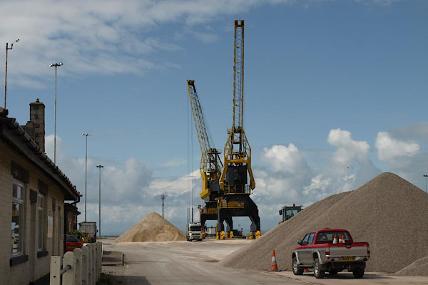 BUN97.jpg Cranes, Prince of Wales Dock. (taken 13.5.2011) 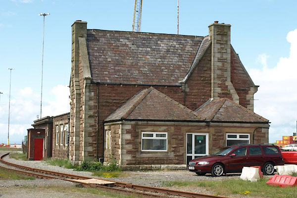 BUN98.jpg Harbour office. (taken 13.5.2011) |
||
|
|
||
Lakes Guides menu.