 Survey of all the Principal Roads of England and
Wales
Survey of all the Principal Roads of England and
Wales

|

|
|
|
map type:- Senex 1719-57 |
|
|
|
Road book, Survey of all the Principal Roads of England
and Wales, including road strip maps with sections in
Westmorland, Cumberland, etc, scales about 2.5 miles to 1
inch, derived from maps by Ogilby, 1675, by John Senex,
London, 1719; revised 1757; published up to 1780s.
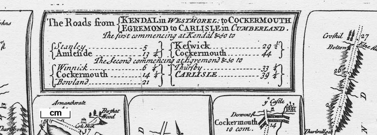
Published in 'An Actual SURVEY of all the PRINCIPAL ROADS of ENGLAND and WALES; Described by One Hundred MAPS from Copper Plates. On which are delineated All the CITIES, TOWNS, VILLAGES, CHURCHES, HOUSES, and Places of Note throughout each Road. As ALSO Directions to the Curious Traveller what is worth observing throughout his Journey: The whole described in the most easy and intelligible Manner. First perform'd and publish'd by JOHN OGILBY, Esq; And now improved, very much corrected, and made portable by JOHN SENEX. VOL. I. Containing all the Direct Roads from LONDON through ENGLAND and WALES. in 54 PLATES. LONDON: Printed for and sold by J. SENEX at the Globe in Salisbury-Court, Fleetstreet, 1719.' Volume 2 of the cross roads in 46 plates. There are title pages and a few pages of text; the road book size is 15x21cm and may well be labelled on the spine as 'Ogilby's Roads 1719'; the maps are reduced from Ogilby's strip maps of 1675, they are numbered bottom right and are plain on the reverse. The pagination matches the roads of John Ogilby of which this road book was intended to be a new version. There were many editions. The plates that concern Westmorland, Cumberland etc, now Cumbria are 38, 62, 86, and 96. Plate 38 in the London to Carlisle road - from Garstang, through Lancaster, Carnford, Lancashire; then Burton, Kendal, Shap, Westmorland; and Penrith to Carlisle, Cumberland. Plate 62 Road from Carlisle to Barwick - from Carlisle, Cumberland; then Jedboro, Kelso, Scotland; to Berwick, Northumberland. Plate 86 Road from Tinmouth to Carlisle - from Tinmouth through Newcastle, Hexham, Haltwesell, Northumberland; then Corby to Carlisle, Cumberland. Plate 96 Roads from Kendal to Cockermouth and Egremont to Carlisle - from Kendal, through Stanley, Ambleside, Westmorland; then Keswick, to Cockermouth, Cumberland AND from Egrimond through Cockermouthto Carlisle, Cumberland. Published in a third edition '... London: Printed for & sold by M. Senex, at the Globe agst St. Dunstans Church Fleetstreet.' an advertisement within includes '... by the late John Senex & continued to be sold by His Widow M. Senex, ...' 1742. The maps are unchanged from the 1719 edition; but it is strongly suspected that plate numbering varies (I have not inspected multiple editions). In at least one edition pl.37 is the number on the route of pl.39, for example. Published in 'The Roads through England delineated or, Ogilby's-Survey, Revised, Improved, and Reduced to a Size portable for the Pocket. By John Senex F.R.S. Being an Actual Survey of all the Principal Roads of England and Wales, Distinctly laid down on one hundred & one Copper Plates ... Printed for John Bowles and Son at the Black Horse in Cornhill London. 1757.' The maps in the road book are the 100 strip maps of the 1719 edition, printed back to back plus one new route and a general map of the country; notes are added in spare spaces; plate numbers are at both top corners; the road book has a title page and introductory text; its size is 8 1/2 x 7 ins; you need big pockets. The pagination is changed in this edition. The plates that concern Westmorland, Cumberland etc, now Cumbria (were 38, 62, 86, 96) are now plates 39, 67, 95, and 82. There are french editions of Senex's maps which are described under Jeffery 1775. |
||

|
Ogilby 1675 | |
|
(strip map example HMCMS:FA1997.99)
|
||
| map feature:- | title cartouche (plain box, sides curved to fit by scrolls of map) & north point (simple cross marked with fleur de lys for N and cross for E) & road distances (miles from Cornhill, London, dot in road, figure beside) & table of distances & roads (continuous or dotted lines probably indicate fenced or unfenced?) & settlements (differences in size and typeface of name are indications of size) & streets (layout in some towns) & rivers & windmills & parks & woods & forests & relief & hillocks (all one way up, ie not using a convention for up and down) & county (dotted line boundary and comment as 'enter Hampshire') | |
| inscription:- |
printed title cartouche
The ROAD from LONDON to PORTSMOUTH / in HAMPSHIRE ... title and table of distances |
|
| wxh, plate:- | 202x159 mm | |
| scale:- | 1 to 150000 ? (1 to 150876 estimated assuming a statute mile) | |
| references:- |
Senex, John: 1719: Actual Survey of all the Principal Roads
of England and Wales: (London) Senex, John: 1742: Actual Survey of all the Principal Roads of England and Wales: Senex, M (London) Senex, John: 1757: Roads through England Delineated & Ogilby's Survey, Revised, Improved, and Reduced: Bowles, John and Son (London) |
|
| sources:- |
Chubb 1927 (CXXXVIII) HMCMS Map Collection JandMN Collection Armitt Library David Webb Collection |
|
| items seen (illustrated items in bold):- | ||
|
|
Armitt Library : ALMC2008.14.104 -- strip map (pl.82/83) -- Road from Kendal to Cockermouth -- Road from Egremond to Carlisle -- Road from King's Lynn to Harwich | |
|
|
Hampshire Museums : FA1999.23 -- road map -- General View of Ogilby's Direct and Principal Cross Roads -- Roads through England Delineated | |
|
|
JandMN (308) -- strip map (pl.38) | |
|
|
JandMN (309) -- strip map (pl.82/83) -- Road from Kendal to Cockermouth -- Road from Egremond to Carlisle -- Road from King's Lynn to Harwich | |
|
|
private collection (272) -- road book -- Actual Survey of all the Principal Roads of England and Wales | |
|
|
private collection (272_1) -- strip map (pl.37) -- Road from London to Carlisle in Cumberland | |
|
|
private collection (272_2) -- strip map (pl.38) -- Road from London to Carlisle in Cumberland | |
|
|
private collection (272_3) -- strip map (pl.62) -- Road from Carlisle to Barwick | |
|
|
private collection (272_4) -- strip map (pl.86) -- Road from Tinmouth to Carlisle | |
|
|
private collection (272_5) -- strip map (pl.96) -- Road from Kendal in Westmorel to Cockermouth -- Road from Egremond to Carlisle in Cumberland | |