 Senex 1719-57

|

|
|
|
item:- Armitt Library : ALMC2008.14.104 image:- © see bottom of page |
click to enlarge |
|
|
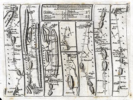
Road strip map, uncoloured engraving, Roads from Kendal
to Cockermouth and from Egremond to Carlisle, in Westmorland
and Cumberland, and on the reverse from Kings Lynn, Norfolk
to Harwich, Essex, scales about 2.5 miles to 1 inch, by John
Senex 1719, edn published by John Bowles and Son, Cornhill,
London, 1757 or later.
Plate 82 in a Survey of all the Principal Roads of England and Wales; it was plate 96 in the first edn 1719 - from Kendall, through Ambleside, Westmorland; then Keswick to Cockermouth, Cumberland AND from Egremont, through Cockermouth, to Carlisle, Cumberland. Plate 83, the reverse, is the Road from Kings Lyn to Harwich, Essex - from Kings Lynn, through Swafham, Thetford, Norfolk; Ixworth, Stowmarket, Ipswich, Suffolk; across a ferry to Harwich, Essex. The maps are derived from maps by Ogilby 1675, and by John Senex 1719 and 1757, etc. |
||

|
Senex 1719-57 | |
| map feature:- | plain cartouche & north point & up is destination & rivers & lakes & relief & hillocks & woods & parks & county & settlements & roads & road distances | |
| inscription:- |
printed title cartouche, top
The Roads from KENDAL in WESTMOREL : to COCKERMOUTH / EGREMOND to CARLISLE in CUMBERLAND. / The first commencing at Kendall pl.38 & so to / Stanley ... 5 / Ambleside ... 13 1/4 / Keswick 29 1/2 / Cockermouth ... 44 / The second commencing at Egremont & so to / Winnick ... 6 1/4 / Cockermouth ... 14 1/4 / Bowland ... 21 / Thursby ... 33 1/4 / CARLISLE ... 39 3/4 |
|
| inscription:- |
recto: printed top left and right
82 / 82 |
|
| inscription:- |
verso: printed top left and right
83 / 83 |
|
| wxh, sheet:- | 23.5x18 | |
| scale:- | 1 to 160000 ? (rough estimate) | |