 Senex 1719-57

|

|
|
|
item:- private collection (272_5) image:- © see bottom of page |
click to enlarge |
|
|
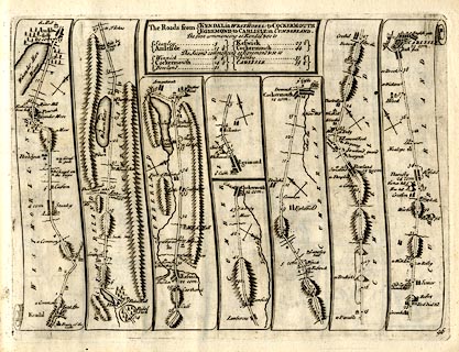
Strip map, road map, The Road from Kendal in Westmorel to
Cockermouth and The Road from Egremond to Carlisle in
Cumberland, by John Senex, The Globe, Salisbury Court, Fleet
Street, London, 1719.
Plate 96 in An Actual Survey of all the Principal Roads of England and Wales. |
||

|
Senex 1719-57 | |
| map feature:- | title cartouche & plain cartouche & north point & up is destination & rivers & lakes & relief & hillocks & county & settlements & roads & road distances & distances from start | |
| inscription:- |
printed plain cartouche, upper centre
The Roads from / KENDAL in WESTMOREL : to COCKERMOUTH / EGREMOND to CARLISLE in CUMBERLAND. / The first commencing at Kendal & so to / Stanley 5 / Amleside 13 1/4 / Keswick 29 1/2 / Cockermouth 44 / The second commencing at Egremond & so to / Winnick 6 1/4 / Cockermouth 14 1/4 / Bowland 21 / Thursby 33 1/4 / CARLISLE 39 1/4 |
|
| inscription:- |
printed bottom right
96 |
|
| wxh, sheet:- | 24x19cm | |
| wxh, plate:- | 215x161mm | |
| wxh, map:- | 214x154mm (approx) | |