 Senex 1719-57

|

|
|
|
item:- private collection (272_3) image:- © see bottom of page |
click to enlarge |
|
|
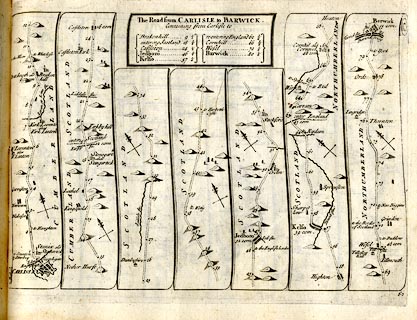
Strip map, road map, The Road from Carlisle to Barwick,
including from Carlisle, Cumberland, and into Scotland at
Kirshopefoot, by John Senex, The Globe, Salisbury Court,
Fleet Street, London, 1719.
Plate 62 in An Actual Survey of all the Principal Roads of England and Wales. |
||

|
Senex 1719-57 | |
| map feature:- | title cartouche & plain cartouche & north point & up is destination & rivers & relief & hillocks & county & settlements & roads & road distances & distances from start | |
| inscription:- |
printed plain cartouche, upper centre
The Road from CARLISLE to BARWICK / Containing from Carlisle to / Brakenhill 9 1/2 / entering Scotland 18 3/4 / Castleton 24 1/2 / Jedboro 46 1/2 / Kelso 57 1/4 / re-entering England 62 3/4 / Cornhill 66 3/4 / Wesel 70 1/4 / Barwick 80 1/4 |
|
| inscription:- |
printed bottom right
62 |
|
| wxh, sheet:- | 24x19cm | |
| wxh, plate:- | 220x165mm | |
| wxh, map:- | 220x151mm (approx) | |