 Camden 1607 map

|

|
|
|
map type:- Camden 1607 map |
|
|
|
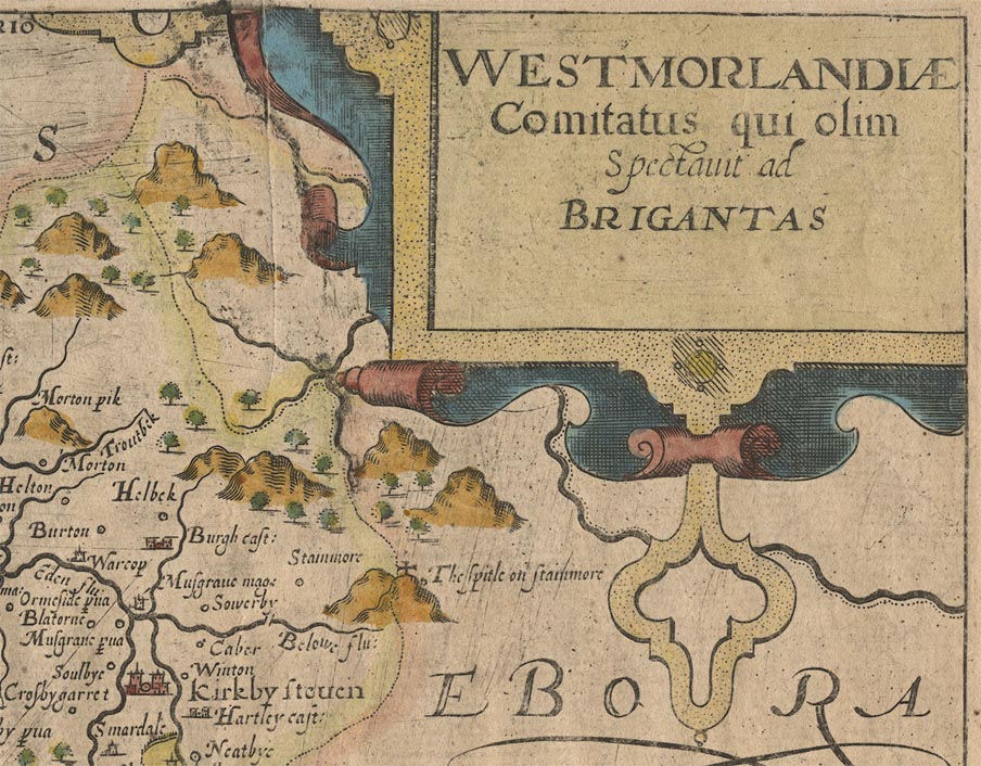
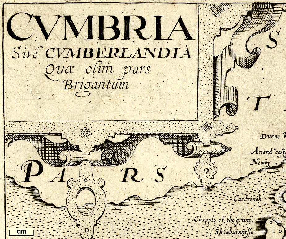
Maps, Westmorlandiae Comitatus, the County of
Westmorland, scale about 3.5 miles to 1 inch, and
Cumberlandia, Cumberland, scale about 5 miles to 1 inch, by
Christopher Saxton, 1576, engraved by William Kip, London,
1607; published 1607-1637.
Published in 'Britannia, sive florentissimorum Regnorum Angliae, Scotiae, Hiberniae, & Insularum adiacentium ex intima antiquitate Chorographica descriptio: Nunc postremo recognita, plurimus locis magna accessione adaucta, & Chartis Chorographicis illustrata. Gulielmo Camdeno Authore. Londini, Impensis Georgii Bishop & Ioannis Norton, M.D.CVII.' ie 1607. The 1607 geography is the 6th and last Latin edition of Camden's Britannia, the first with county maps although William Camden considered maps as early as 1589. The Westmorland and Cumberland maps are smaller versions of Saxton's maps engraved by Kip; many other counties, but not all, are also Kip versions of Saxton. The maps have Latin text on the reverse; the geography has an illustrated title page, and has a map of England in the Heptarchy; its size is 8 1/4 x 12 1/2 ins. Published in 'Britain, Or A Chorographicall Description of the most flourishing Kingdomes, England, Scotland, and Ireland, and the Ilands adioyning, out of the depth of Antiquitie: Beautified with mappes of the severall Shires of England: Written first in Latine by William Camden ... Translated newly into English by Philemon Holland ... Finally, revised, amended, and enlarged with sundry Additions by the said Author. Londini. Impensis Georgii Bishop & Ioannis Norton, M.DC.X.' ie 1610. The maps in the 1610 edition, the first in English, are the same as in the 1607 edition of Camden, but there is no text on the reverse. Published in 'Britain or a chorographicall description of England ... translated ... by P. Holland ... London. Printed by F. K. R. Y. and I. L. for Andrew Heb, 1637.' In the 1637 atlas the worn plates might be retouched, and some, including Westmorland, now have plate numbers. A crib to printings - 1607 latin text on reverse, no plate number; 1610 plain reverse, no plate number; from 1637 plate number. |
||

|
Saxton 1579 | |
| see:- | Camden 1586 | |
| see:- | Camden 1610 | |
|
( example map Dove Cottage : 2007.38.10)
|
||
| map feature:- | title cartouche & strapwork cartouche & swash lettering & labelled borders (Latin) & up is N & scale line & sea pecked & coast shaded & rivers & lakes & relief & hillocks & woods & trees & forests & parks & county & settlements | |
| inscription:- |
printed title cartouche, upper right
WESTMORLANDIAE / Comitatus qui olim / Spectavit ad / BRIGANTAS |
|
| inscription:- |
printed below scale line, lower right
Christophorus Saxton scripsit / William Kip sculpsit |
|
| inscription:- |
water mark:
crown and bunch of grapes |
|
| wxh, sheet:- | 38.5x32.5cm | |
| wxh, plate:- | 315x264mm | |
| wxh, map:- | 313x262mm | |
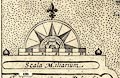
| inscription:- |
printed above scale line
Scala Miliarium |
|
| scale line:- | 8 miles = 55.8 mm | |
| scale:- | 1 to 230000 ? (1 to 230730 from scale line wrongly assuming a statute mile) | |
|
||
|
||
| references:- |
Camden, William: 1607: Britannia: Bishop, George & Norton,
John (London) Camden, William & Holland, Philemon (trans): 1610: Britain Camden, William & Holland, Philemon (trans): 1637: Britain: Heb, Andrew (London) |
|
| sources:- |
Chubb 1927 (XVIII) Curwen 1918 Wordsworth Trust Collection JandMN Collection Armitt Library private collection Carlisle Library Maps Kendal Library Maps |
|
| items seen (illustrated items in bold):- | ||
|
|
Armitt Library : ALMC2008.14.6 -- map -- Westmorlandiae | |
|
|
Armitt Library : ALMC2008.14.7 -- map -- Westmorlandiae | |
|
|
Carlisle Library : Map 135 -- map -- Cumbria -- Cumberlandia | |
|
|
Carlisle Library : Map 136 -- map -- Cumbria -- Cumberlandia | |
|
|
Carlisle Library : Map 165 -- map -- Westmorlandiae | |
|
|
Carlisle Library : Map 318 -- map -- Cumbria -- Cumberlandia | |
|
|
Carlisle Library : Map 345 -- map -- Westmorlandiae | |
|
|
Dove Cottage : 2007.38.10 -- map -- Westmorlandiae | |
|
|
Dove Cottage : 2007.38.11 -- map watermark -- Westmorlandiae | |
|
|
Dove Cottage : 2007.38.12 -- map watermark -- Cumbria -- Cumberlandia | |
|
|
Dove Cottage : 2007.38.13 -- map -- Cumbria -- Cumberlandia | |
|
|
JandMN (139) -- map -- Westmorlandiae Comitatus -- County of Westmorland | |
|
|
Kendal Library : Map 94 -- map -- Westmorlandiae Comitatus -- County of Westmorland | |
|
|
Kendal Library : Map 95 -- map -- Westmorlandiae Comitatus -- County of Westmorland | |
|
|
Kendal Library : Map 96 -- map -- Westmorlandiae Comitatus -- County of Westmorland | |
|
|
Kendal Library : Map 97 -- map -- Westmorlandiae Comitatus -- County of Westmorland | |
|
|
Kendal Library : Map 98 -- map -- Westmorlandiae Comitatus -- County of Westmorland | |
|
|
Kendal Library : Map 110 -- map -- Westmorlandiae Comitatus -- County of Westmorland | |
|
|
Kendal Library : Map 122 -- map -- Westmorlandiae Comitatus -- County of Westmorland | |
|
|
private collection (60) -- map -- Westmorlandiae Comitatus -- County of Westmorland | |
|
|
private collection (167) -- map -- Eboracensis Comitatus pars Occidentalis -- West Riding | |
|
|
private collection (211) -- map -- Westmorlandiae Comitatus -- County of Westmorland | |