 Saxton 1579

|

|
|
|
map type:- Saxton 1579 |
|
|
|
Map, Westmorlandiae et Cumberlandiae Comitatus ie
Counties of Westmorland and Cumberland, scale about 5 miles
to 1 inch, by Christopher Saxton, London, engraved by
Augustinus Ryther, 1576 and presumably available from that
date, published with other county maps in an atlas 1579;
published 1579-1645.
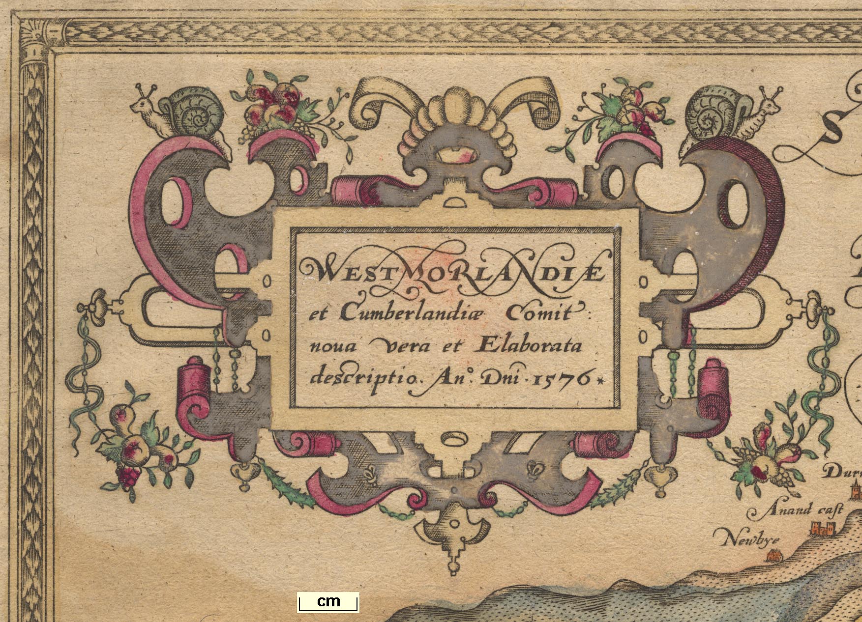
Published in 'An Atlas of England and Wales by Christopher Saxton. London. 1579.' The 1576 map carries the royal arms, of Elizabeth I, and the coat of arms of Thomas Seckford with his motto 'Industria Naturam Ornat' -- 'hard work improves on nature'; there are no roads. The Lancashire map dates from 1577; the atlas has a general map of England and Wales. The 1579 atlas has a frontispiece portrait of Elizabeth I, a map of England, and includes a count of cities, bishoprics, market towns, castles, parishes, churches, rivers, bridges, chases, forests and parks, in each county; the atlas size is 9 1/4 x 14 3/4 ins. Christopher Saxton was born 1542 or 1544 in Dunningley, or Wakefield, Yorkshire, and was latterly an estate surveyor. The survey for the map was done with the patronage of Thomas Seckford, Master of Requests to Elizabeth I; it is thus an officially sponsored map, one of a series for the whole country. Saxton died after about 1606. Published in 'The Maps of all the Shires in England, and Wales. Exactly taken and truly described by Christopher Saxton. And graven at the Charges of a private Gentleman for the publicke good. Now newly Revised, Amended, and Reprinted. Printed for William Web at the Globe in Cornehill, 1645.' In the 1645 atlas the map title is Comberland and Westmorland Exactly Described. 1642; the original date remains lower left; the arms of Elizabeth I replaced by those of Charles I; this late publication probably arose from a demand for county maps consequent on the Civil War. Other changes were made about 1665. And an altered version of the map is published from about 1690, see Lea 1690. Summarising, the map plate was later in possession of, and perhaps altered by:- William Webb, from 1642, dated 1642; unknown mapseller, 1665; Philip Lea, about 1683-93, additional features; George Willdey, about 1720; Thomas Jeffreys, about 1749; C Dicey and Co, about 1770. |
||

|
Camden 1607 map | |
|
|
Lea 1689 | |
|
Example map (private collection(3))
|
||
| map feature:- | picture frame border & coat of arms, royal & coat of arms (family) & strapwork cartouche & labelled borders & scale line & compasses & sea monsters & galleons & sea pecked & coast shaded & rivers & relief & hillocks (some large) & parks & county & settlements | |
| inscription:- |
printed lower left
CHRISTOPHORUS SAXTON DESCRIPSIT |
|
| inscription:- |
printed strapwork title cartouche, upper left
WESTMORLANDIAE et Cumberlandiae Comit~ nova Vera et Elaborata descriptio. Ano. Dn~i. 1576. |
|
| inscription:- |
printed under scale line, lower left
AUGUSTINUS RYTHER ANGLUS SCULPSIT ANo DN~I 1576 |
|
| scale line:- | 10 miles = 65.4 mm | |
| scale:- | 1 to 250000 ? (1 to 246077 from scale line wrongly assuming a statute mile) | |
| scale:- | 1 to 300000 ? (from scale line using Old English Mile of 1.25 statute mile) | |
|
||
| references:- |
Saxton, Christopher: 1579: Atlas of England and Wales:
(London) : 1645: Maps of all the Shires in England, and Wales: Web, William (London) Fordham, H G, Sir: 1928: Christopher Saxton of Dunningley, his life and work: (Leeds, Yorkshire) Lynam, E (author of introduction): 1934 & 1939: Atlas of England and Wales, the Maps of Christopher Saxton engraved 1574-79 (facsimile): British Museum Whitaker, H: 1939: Later Editions of Saxton's Maps: Imago Mundi: 3: pp.72-86 Evans, Ifor M & Lawrence, Heather: 1979: Christopher Saxton, Elizabethan Mapmaker: Wakefield Historical Publications & Holland Press (Wakefield, Yorkshire) Tyack, Sarah & Huddy, John: 1980: Christopher Saxton and Tudor Mapmaking: British Library (London) |
|
| sources:- |
Chubb 1927 (I and VII) Curwen 1918 David Webb Collection Kendal Library Maps |
|
| items seen (illustrated items in bold, * have map squares etc):- | ||
|
|
Chetham's Library (2) -- map -- Lancastriae | |
|
|
Kendal Library : Map 2 -- map -- Westmorlandiae et Cumberlandiae Comitatus | |
|
|
private collection (2) -- map -- Westmorlandiae et Cumberlandiae Comitatus * | |
|
|
private collection (15) -- map -- Anglia | |