 Camden 1607 map

|

|
|
|
item:- private collection (167) image:- © see bottom of page |
click to enlarge |
|
|
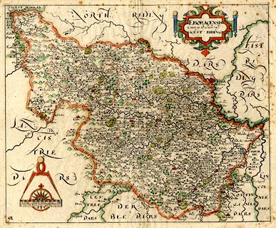
Map, hand coloured engraving, Eboracensis Comitatus pars
Occidentalis, West Riding, Yorkshire, scale about 5 miles to
1 inch, by Christopher Saxton, 1576, engraved by William
Hole, London, 1607; published by George Bishop and John
Norton, London, 1610 edn 1637.
The map comes from the first English translation of Britannia by William Camden, translated by Philemon Holland, 1610 edn 1637. The plate has no text on the reverse; plate number 48. |
||

|
Camden 1607 map | |
| map feature:- | swash lettering & strapwork cartouche & compass rose & up is N & scale line & rivers & bridges & lakes & relief & hillocks & woods & parks & county & settlements | |
| inscription:- |
printed title cartouche, upper right
EBORACENSIS / Comitatus pars Occidentalis vulgo / WST RIDING |
|
| inscription:- |
printed lower left
Christophorus Saxton discripsit Gulielmus Hole sculpsit |
|
| scale line:- | 10 miles = 49.1 mm | |
| scale:- | 1 to 330000 ? (1 to 327769 from scale line wrongly assuming a statute mile) | |
| wxh, sheet:- | 34.5x29cm | |
| wxh, map:- | 316x263mm | |