 Old Cumbria Gazetteer
 |
 |
|
|
| Lancaster Canal | |||
| Lancaster and Kendal Canal | |||
| Black and White Canal | |||
| civil parish:- | Kendal (formerly Westmorland) | ||
| civil parish:- | Natland (formerly Westmorland) | ||
| civil parish:- | Helsington (formerly Westmorland) | ||
| civil parish:- | Sedgwick (formerly Westmorland) | ||
| civil parish:- | Hincaster (formerly Westmorland) | ||
| civil parish:- | Stainton (formerly Westmorland) | ||
| civil parish:- | Preston Richard (formerly Westmorland) | ||
| civil parish:- | Preston Patrick (formerly Westmorland) | ||
| civil parish:- | Beetham (formerly Westmorland) | ||
| civil parish:- | Holme (formerly Westmorland) | ||
| civil parish:- | Burton-in-Kendal (formerly Westmorland) | ||
| county:- | Cumbria | ||
| locality type:- | canal | ||
| 10Km square:- | SD59 | ||
| 10Km square:- | SD58 | ||
| 10Km square:- | SD57 | ||
| county:- | Lancashire | ||
| locality type:- | canal | ||
| references:- | 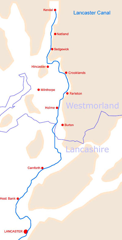 CAN001.jpg route taken |
||
|
|
|||
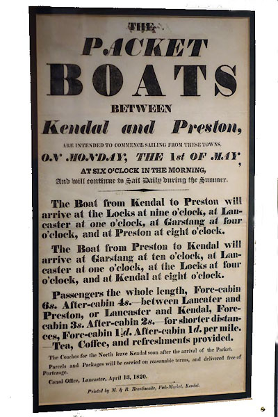 BZG19.jpg Advertisement for packet boats. (taken 6.9.2013) courtesy of Lancaster Museums. 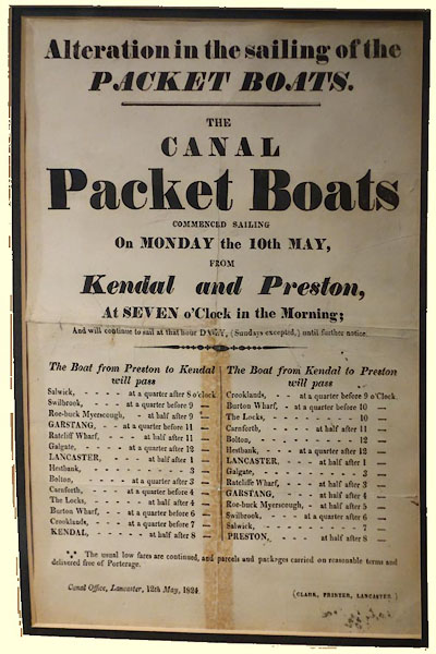 BZG18.jpg Timetable for packet boats. (taken 6.9.2013) courtesy of Lancaster Museums. |
|||
|
|
|||
| evidence:- | old map:- OS County Series (Wmd 38 12) placename:- Lancaster and Kendal Canal |
||
| source data:- | Maps, County Series maps of Great Britain, scales 6 and 25
inches to 1 mile, published by the Ordnance Survey, Southampton,
Hampshire, from about 1863 to 1948. OS County Series (Wmd 42 4) OS County Series (Wmd 42 8) OS County Series (Wmd 43 13) OS County Series (Wmd 46 12) OS County Series (Wmd 47 1) |
||
|
|
|||
| evidence:- | old text:- Gents Mag item:- canal map; Plan of the Proposed Navigable Canal ... to Kendal |
||
| source data:- | Map, uncoloured engraving, Plan of the Proposed Navigable Canal ... to Kendal, scale
about 4 miles to 1 inch, by Robert Whitworth, published by the Gentleman's Magazine,
1772. goto source goto sourceGentleman's Magazine 1772 opp p.608 Canal map, uncoloured engraving, Plan of the Proposed Navigable Canal ... to Kendal, scale about 4 miles to 1 inch, by Robert Whitworth, published by the Gentleman's Magazine, 1772. 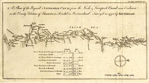 click to enlarge click to enlargeGM17.jpg "A Plan of the Proposed NAVIGABLE CANAL from the Leeds &Liverpool Canal near Eccleston in the County Palatine of Lancaster, to Kendal in Westmorland. Survey'd in 1772, by Robt. Whitworth." Size: wxh, sheet = 36.5x21.5cm; wxh, map = 311x166mm; scale: 1 to 260000? 1 item:- Armitt Library : Gents Mag 1772.1 Image © see bottom of page |
||
|
|
|||
| evidence:- | old text:- Gents Mag 1773 |
||
| source data:- | Map, uncoloured engraving, A General Plan of the Several Canals
given in the Course of this Magazine, engraved by Thomas Bowen,
published by the Gentleman's Magazine, 1773. goto source Gentleman's Magazine 1773 opp p.221 Canal map, uncoloured engraving, A General Plan of the Several Canals given in the Course of this Magazine, engraved by Thomas Bowen, published by the Gentleman's Magazine, 1773. "A GENERAL PLAN of the several CANALS given in the Course of this Magazine" Size: wxh, sheet = 25x21cm; wxh, map = 205x174mm. Detail:- 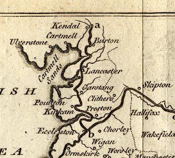 click to enlarge click to enlargeGM19Cm.jpg item:- Armitt Library : Gents Mag 1773.1 Image © see bottom of page |
||
|
|
|||
| evidence:- | old map:- Whitworth 1772 |
||
| source data:- | Map, uncoloured engraving, Plan of the Proposed Navigable Canal ... to Kendal, scale
about 4 miles to 1 inch, by Robert Whitworth, published by the Gentleman's Magazine,
1772. click to enlarge GM17.jpg "Plan of the Proposed NAVIGABLE CANAL from the Leeds &Liverpool Canal near Eccleston in the County Palatine of Lancaster, to Kendal in Westmorland. Suvey'd in 1772 by Robt. Whitworth." item:- Armitt Library : Gents Mag 1772.1 Image © see bottom of page |
||
|
|
|||
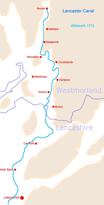 CAN003.jpg |
|||
| route of canal as shown on Whitworth 1772 |
|||
|
|
|||
| evidence:- | descriptive text:- West 1778 (11th edn 1821) item:- limestone; slate; coal |
||
| source data:- | Guide book, A Guide to the Lakes, by Thomas West, published by
William Pennington, Kendal, Cumbria once Westmorland, and in
London, 1778 to 1821. goto source Page 24:- "[1] ... In the year 1792 an act was obtained, chiefly promoted by the inhabitants of Lancaster for making a navigable canal, from Kendal, by way of Lancaster and Preston, to go through the great coal countries in the neighbourhood of Chorley and Wigan, and to join the canals in the south of Lancashire, its principal design being for the carriage of limestone and slate from the north, and to return with coals. It is carried over the river Lune by the largest aqueduct in the kingdom, which is an amazing grand object, and is seen to advantage from Lancaster bridge, about two miles off." |
||
|
|
|||
| evidence:- | old map:- West 1784 map placename:- Lancaster Canal |
||
| source data:- | Map, hand coloured engraving, A Map of the Lakes in Cumberland,
Westmorland and Lancashire, scale about 3.5 miles to 1 inch,
engraved by Paas, 53 Holborn, London, about 1784.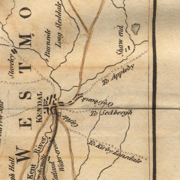 Ws02SD59.jpg 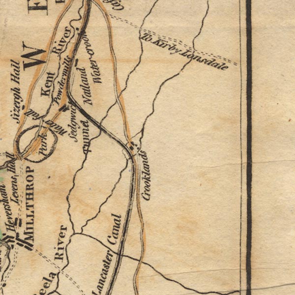 Ws02SD58.jpg 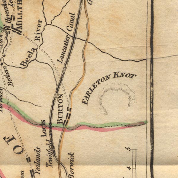 Ws02SD57.jpg 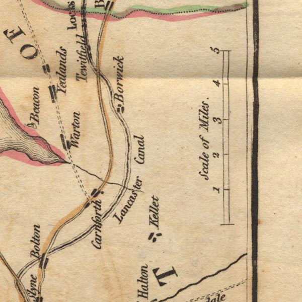 Ws02SD56.jpg 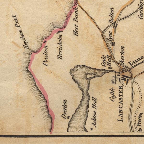 Ws02SD45.jpg 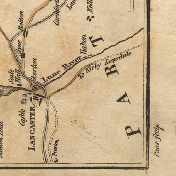 Ws02SD55.jpg item:- Armitt Library : A1221.1 Image © see bottom of page |
||
|
|
|||
| evidence:- | old map:- Cary 1789 (edn 1805) |
||
| source data:- | Map, uncoloured engraving, Westmoreland, scale about 2.5 miles
to 1 inch, by John Cary, London, 1789; edition 1805.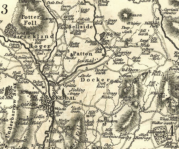 CY24SD59.jpg 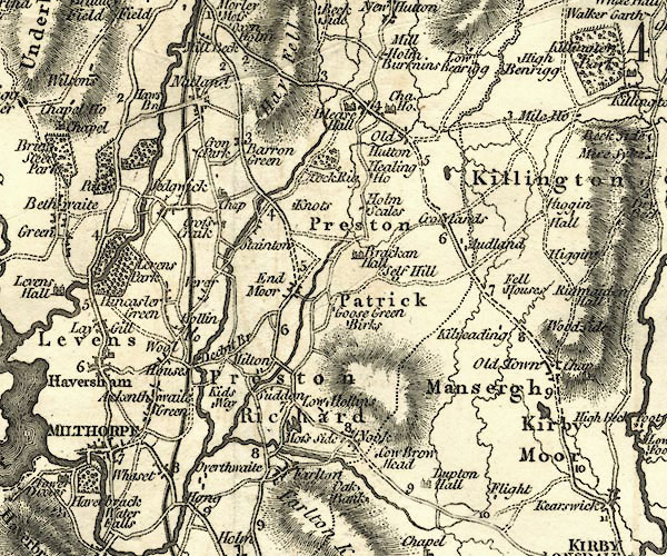 CY24SD58.jpg 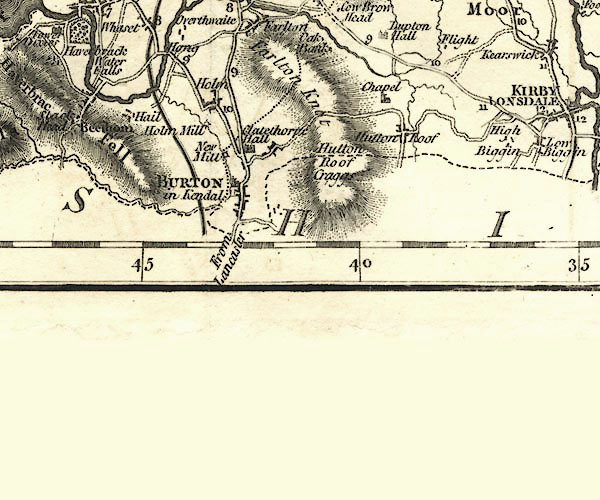 CY24SD57.jpg triple line, bold light bold; this map predates the enabling act of the canal, the route shown is not the route dug. item:- JandMN : 129 Image © see bottom of page |
||
|
|
|||
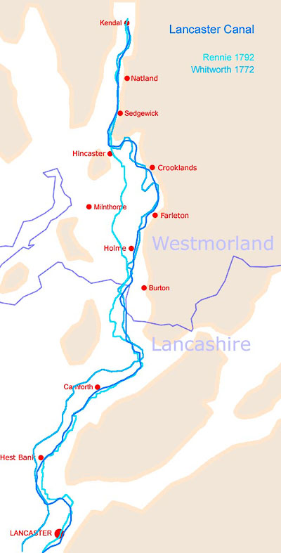
| evidence:- | old map:- Rennie 1792 |
||
| source data:- | Canal map, uncoloured engraving, Plan of the Proposed Lancaster Canal, scale about
1 miles to 1 inch, surveyed by John Rennie, 1791-92, engraved by William Faden, London,
1792.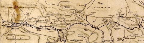 click to enlarge click to enlargeREN1Can.jpg Plan of the Proposed Lancaster Canal, scale about 1 miles to 1 inch, surveyed by John Rennie, 1791-92, engraved by William Faden, London, 1792. Much of the proposed route is a contour canal, and was not used for the parts north of Tewitfield; the canal runs from near Wigan, through Preston and Lancaster, Lancashire; to Kendal, Westmorland. There is a table of distances printed lower right - Kendal to Greenhead Farm 5 miles 1 furlong 1 chain 20 links, level; to near Borwick, 9m 1f 7ch 75l, fall 65 feet; to Preston, 42m 5f 1ch 28l, level; to Clayton Green, 3m 0f 5ch 75l, rises 220 feet; to West Houghton 15m 5f 3ch 72l, level; total 75 miles 5 furlongs 9 chains 70 links. There are collateral cuts to Duxbury, and to Warton Crag; and a feeder from the River Mint near Mint Bridge to the bason at Kendal. Minerals are indicated at various places; Lime, Free Stone, Coal, Cannel. "PLAN / of the proposed / Lancaster Canal / from KIRKBY KENDAL in the COUNTY of WESTMORLAND / to / WEST HOUGHTON in the COUNTY of PALATINE LANCASHIRE / Surveyed in the Years 1791 &1792 / By JOHN RENNIE, Engineer. F.R.S.E. / Engraved by W. Faden, Geogr. to the King 1792." 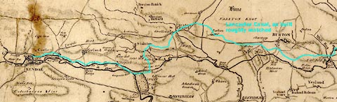 click to enlarge click to enlargeREN1Can2.jpg item:- Kendal Museum : 0049/94T Image © see bottom of page |
||
|
|
|||
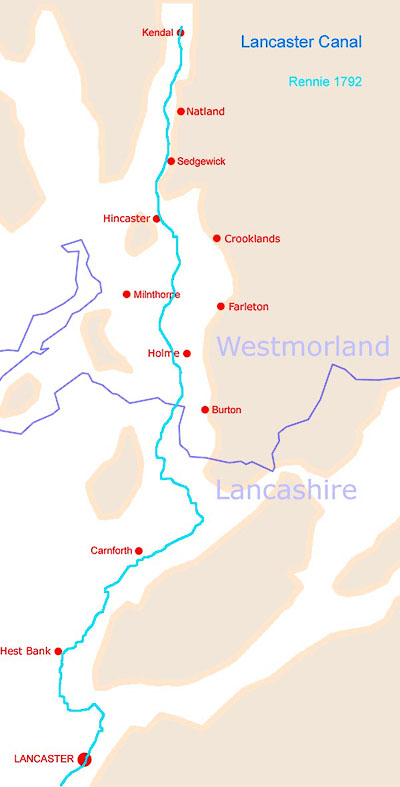 CAN002.jpg |
|||
| route of canal as shown on Rennie 1792 |
|||
|
|
|||
| evidence:- | old map:- Bailey 1797 |
||
| source data:- | Map, soil etc, uncoloured engraving, Westmoreland, scale about
12 miles to 1 inch, by J Bailey, engraved by Neele, Strand,
published by Messrs Robinson, Paternoster Row and G Nicol, Pall
Mall, London, 1797. click to enlarge click to enlargeBY05.jpg "canal" item:- Armitt Library : A680.3 Image © see bottom of page |
||
|
|
|||
| evidence:- | descriptive text:- Baker 1802 |
||
| source data:- | Perspective road map with sections in Lancashire, Westmorland,
and Cumberland, by J Baker, London 1802. pp.25-26:- "... a navigable canal, lately formed from the coal countries about Chorly, and which passes hence to Kendal. ..." |
||
|
|
|||
| evidence:- | old map:- Laurie and Whittle 1806 |
||
| source data:- | Road map, Completion of the Roads to the Lakes, scale about 10
miles to 1 inch, by Nathaniel Coltman? 1806, published by Robert
H Laurie, 53 Fleet Street, London, 1834. click to enlarge click to enlargeLw18.jpg triple line, light bold light; canal item:- private collection : 18.18 Image © see bottom of page |
||
|
|
|||
| evidence:- | old text:- Capper 1808 |
||
| source data:- | Gazetteer, A Topographical Dictionary of the United Kingdom,
compiled by Benjamin Pitts Capper, published by Richard
Phillips, Bridge Street, Blackfriars, London, 1808; published
1808-29. goto source "[Kendal] ... By the inland navigation this town has communication with the rivers Mersey, Dee, Ribble, Ouse, Trent, Severn, Humber, Thames, Avon, &c. extending above 500 miles through most of the inland counties. ..." goto source"... It [Burton-in-Kendal] has a canal navigation joining the rivers Ribble, Dee, Mersey, Humber, Severn, and Thames. ..." |
||
|
|
|||
| evidence:- | old map:- Cooper 1808 |
||
| source data:- | Map, hand coloured engraving, Westmoreland ie Westmorland, scale
about 9 miles to 1 inch, by H Cooper, 1808, published by R
Phillips, Bridge Street, Blackfriars, London, 1808. click to enlarge click to enlargeCOP4.jpg bold line; canal item:- Dove Cottage : 2007.38.53 Image © see bottom of page |
||
|
|
|||
| evidence:- | old map:- Wallis 1810 (Wmd) |
||
| source data:- | Road map, Westmoreland, scale about 19 miles to 1 inch, by James
Wallis, 77 Berwick Street, Soho, 1810, published by W Lewis,
Finch Lane, London, 1835? click to enlarge click to enlargeWAL5.jpg triple line, light bold light item:- JandMN : 63 Image © see bottom of page |
||
|
|
|||
| evidence:- | old map:- Otley 1818 placename:- Lancaster Canal |
||
| source data:- | Map, uncoloured engraving, The District of the Lakes,
Cumberland, Westmorland, and Lancashire, scale about 4 miles to
1 inch, by Jonathan Otley, 1818, engraved by J and G Menzies,
Edinburgh, Scotland, published by Jonathan Otley, Keswick,
Cumberland, et al, 1833. OT02SD59.jpg 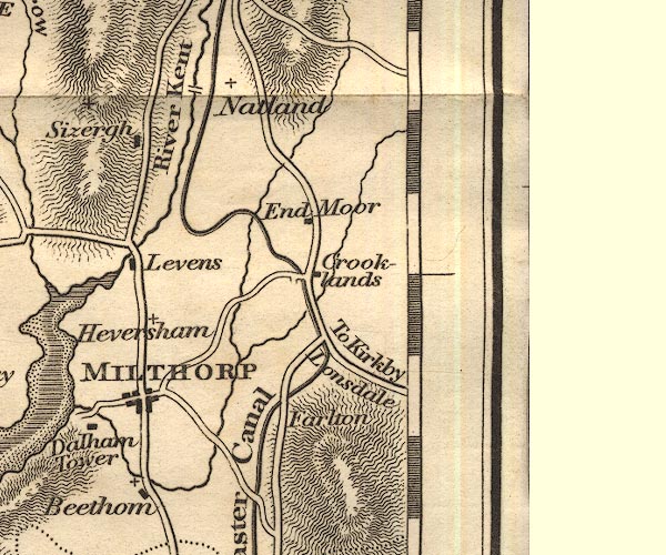 OT02SD58.jpg 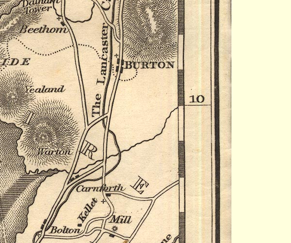 OT02SD57.jpg  OT02SD47.jpg  OT02SD46.jpg "The Lancaster Canal" item:- JandMN : 48.1 Image © see bottom of page |
||
|
|
|||
| evidence:- | descriptive text:- Otley 1823 (5th edn 1834) |
||
| source data:- | Guide book, A Concise Description of the English Lakes, the
mountains in their vicinity, and the roads by which they may be
visited, with remarks on the mineralogy and geology of the
district, by Jonathan Otley, published by the author, Keswick,
Cumberland now Cumbria, by J Richardson, London, and by Arthur
Foster, Kirkby Lonsdale, Cumbria, 1823; published 1823-49,
latterly as the Descriptive Guide to the English Lakes. goto source Page 92:- "... It is a sea-port upon the Lune, over which there ... about a mile further up a grand aqueduct, by which the Canal is conducted across the river." "..." "A quick sailing Packet Boat, for the conveyance of passengers, has lately been established, every day, between Preston and Kendal, through Lancaster." |
||
|
|
|||
| evidence:- | descriptive text:- Ford 1839 (3rd edn 1843) |
||
| source data:- | Guide book, A Description of Scenery in the Lake District, by
Rev William Ford, published by Charles Thurnam, Carlisle, by W
Edwards, 12 Ave Maria Lane, Charles Tilt, Fleet Street, William
Smith, 113 Fleet Street, London, by Currie and Bowman,
Newcastle, by Bancks and Co, Manchester, by Oliver and Boyd,
Edinburgh, and by Sinclair, Dumfries, 1839. goto source Page 20:- "... [Kendal]" "... The completion of the canal to Lancaster, in 1819, gave a powerful impulse to the building spirit of the inhabitants, which still continues to extend the limits of the town, and to improve its general appearance and accommodations." goto sourcePage 152:- "The trade of Lancaster is very considerable, not only at Glasson Dock, where the larger ships generally unload but also at the Canal, which is one of very great extent, and connected with many of the principal towns in the manufacturing districts. ..." |
||
|
|
|||
| evidence:- | old map:- Ford 1839 map |
||
| source data:- | Map, uncoloured engraving, Map of the Lake District of
Cumberland, Westmoreland and Lancashire, scale about 3.5 miles
to 1 inch, published by Charles Thurnam, Carlisle, and by R
Groombridge, 5 Paternoster Row, London, 3rd edn 1843.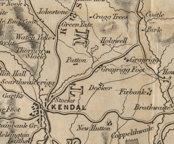 FD02SD59.jpg 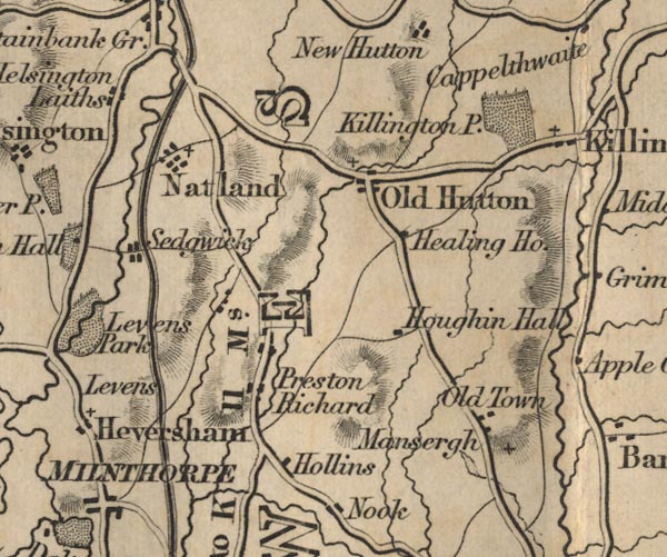 FD02SD58.jpg 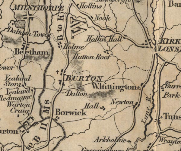 FD02SD57.jpg 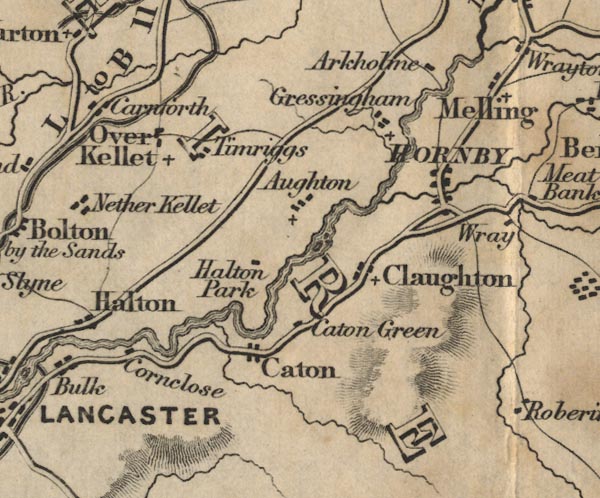 FD02SD56.jpg 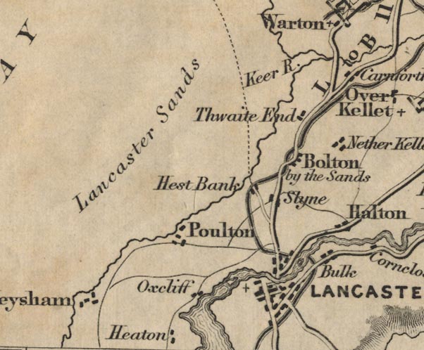 FD02SD46.jpg item:- JandMN : 100.1 Image © see bottom of page |
||
|
|
|||
| evidence:- | old map:- Garnett 1850s-60s H |
||
| source data:- | Map of the English Lakes, in Cumberland, Westmorland and
Lancashire, scale about 3.5 miles to 1 inch, published by John
Garnett, Windermere, Westmorland, 1850s-60s.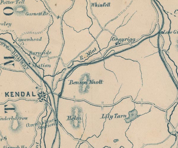 GAR2SD59.jpg bold line 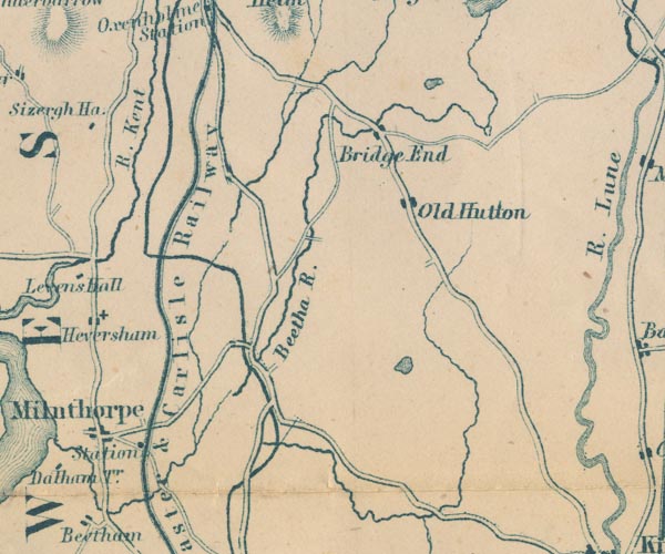 GAR2SD58.jpg 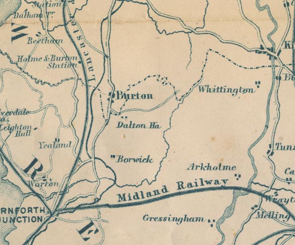 GAR2SD57.jpg 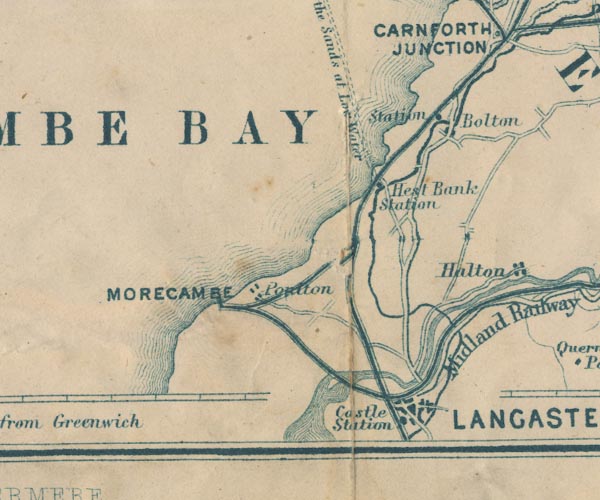 GAR2SD46.jpg item:- JandMN : 82.1 Image © see bottom of page |
||
|
|
|||
 Act of Parliament Act of Parliament |
|||
|
|
|||
| observation:- |
At present, the canal ends south of Tewitfield Locks. Though some sections further
north have water and may be navigable. |
||
| The canal brough coal north from Wigan, and took limestone south from Kendal; it is
said that it was called the 'Black and White Canal' |
|||
| "Black one way, white the other." |
|||
|
|
|||
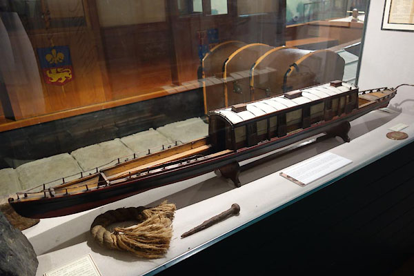 BZG17.jpg Model of the fly boat Crewdson. (taken 6.9.2013) courtesy of Lancaster Museums. |
|||
| The fly boat Crewdson was built 1829 for passenger services between Preston and Kendal.
It was withdrawn 1846, and rebuilt for other work. The model was made in 1915 (LANLM:LM15.8). |
|||
|
|
|||
| : 2000: History of the Lancaster-Kendal Canal and its Associated Industries: Kendal
Civic Society:: unpublished report, see Kendal Library, Local Studies WOO386.4 Curwen, John F: 1917: Lancaster Canal: TCWAAS: new series vol.17: pp.26-47 and map Perrott, David (ed): 1985 (2nd edn): Nicholson/Ordnance Survey Guide to the Waterways, 3 North: Nicholson, Robert, Publcations &Ordnance Survey:: ISBN 0 905522 75 3 Philpotts: 1983: Building the Lancaster Canal: Blackwater Books (London):: ISBN 0 946623 00 7 Rigby, Janet: 2006 (?): Life on the Lancaster Canal: Landty Publishing (Staining, Lancashire):: ISBN 1 872895 66 2 Rigby, Janet: 2007: Lancaster Canal in Focus: Landy Publications (Staining, Lancashire):: ISBN 1 872895 72 7 Satchell, John: 2000: Kendal's Canal, History, Industry and People: Kendal Civic Society:: ISBN 0 9509869 1 7 Slater, David & Main, Martin & Clark, Jon & Blndell, Lesley: 2003 (3rd edn) &1989: Lancaster Canal Trust Slater, David (et al): 2000 (2nd edn) &1989: Complete Guide to the Lancaster Canal: Lancaster Canal Trust:: ISBN 0 95141 46 1 Swan, Robert: 1990: Walker's Guide to the Lancaster Canal: Cicerone Press (Milnthorpe, Cumbria):: ISBN 1 85284 055 2 Wilson, Paul N: 1968: Canal Head, Kendal: TCWAAS: new series vol.68: pp.132-150 |
|||
|
|
|||
| notes:- |
Various routes overlaid (not perfect accuracy). |
||
 CAN004.jpg |
|||
|
|
|||
| person:- | engineer : Rennie, John |
||
| date:- | 1791 to 1792 |
||
| period:- | 18th century, late | ||
| period:- | 1790s | ||
| John Rennie was approached by a group of Lancaster merchants to plan a canal to connect
Lancaster, Lancashire and Kendal, Westmorland to coal fields in Lancashire, 1791;
survey 1792. The enabling act was passed 10 May 1792, 32 Geo III 1792. The idea was
to transport coal north, and slates and limestone south. Act of Parliament passed
25 June 1792. |
|||
| 'Black one way, white the other' |
|||
| Wigan to Preston open 1797. |
|||
| Marshall, J D &Davies-Shiel, Michael: 1977 (2nd edn): Industrial Archaeology of the
Lake Counties: Moon, Michael (Beckermet, Cumbria):: ISBN 0 904131 13 0 |
|||
|
|
|||
| person:- | engineer : Fletcher, Thomas |
||
| date:- | 1813 |
||
| period:- | 19th century, early | ||
| period:- | 1810s | ||
| the last section opened was Tewitfield to Kendal, 1819. This followed a new line surveyed
by Thomas Fletcher, which involved six locks at Tewitfield, then a contour route into
Kendal. |
|||
| A section in the middle of the southern part was never completed. |
|||
|
|
|||
| goes through:- | Tewitfield Turnpike Bridge, Lancaster Canal Tewitfield Wharf, Lancaster Canal Tewitfield Bridge, Lancaster Canal Tewitfield Locks, Lancaster Canal Lark Bridge, Lancaster Canal Saltermire Bridge, Lancaster Canal Cinderbarrow Culvert, Lancaster Canal Yealand Road Bridge, Lancaster Canal Moss Side Bridge, Lancaster Canal Burton Wharf, Lancaster Canal Burton Road Aqueduct, Lancaster Canal New Mill Aqueduct, Lancaster Canal Braithwaites Bridge, Lancaster Canal winding point, Lancaster Canal Holme Mill Bridge, Lancaster Canal stone, Holme Sheernest Bridge, Lancaster Canal Holme Turnpike Bridge, Lancaster Canal Jansons Bridge, Lancaster Canal winding point, Lancaster Canal (2) Warehouse Bridge, Lancaster Canal winding point, Lancaster Canal (7) Holme Park Bridge, Lancaster Canal Nelsons Bridge, Lancaster Canal Holme North Road Bridge, Lancaster Canal Garths Bridge, Lancaster Canal Spinney Culvert, Lancaster Canal Dukes Bridge, Lancaster Canal Farleton Basin, Lancaster Canal Farleton Turnpike Bridge, Lancaster Canal Hodgsons Bridge, Lancaster Canal Thompsons Bridge, Lancaster Canal Atkinsons Bridge, Lancaster Canal Farleton Aqueduct, Lancaster Canal winding point, Lancaster Canal (5) Dovehouses Bridge, Lancaster Canal Moss Side Bridge, Lancaster Canal (2) Seven Milestone Bridge, Lancaster Canal M6 Bridge, Lancaster Canal canal basin, Lancaster Canal Millness Bridge, Lancaster Canal canal feeder, Lancaster Canal Crooklands Aqueduct, Lancaster Canal canal wharf, Lancaster Canal Crooklands Bridge, Lancaster Canal Wakefield's Wharf, Lancaster Canal Old Hall Bridge, Lancaster Canal Mattinsons Bridge, Lancaster Canal winding point, Lancaster Canal (6) Field End Bridge, Lancaster Canal stop gates, Lancaster Canal Bridge End Bridge, Lancaster Canal Stainton Aqueduct, Lancaster Canal Stainton Crossing Bridge, Lancaster Canal Sellet Hall Bridge, Lancaster Canal Wellheads Bridge, Lancaster Canal Hincaster Tunnel, Lancaster Canal Howard's Bridge, Lancaster Canal Sedgwick Hill Bridge, Lancaster Canal Sedgwick Aqueduct, Lancaster Canal Horse Park Bridge, Lancaster Canal winding point, Lancaster Canal (8) Larkrigg Hall Bridge, Lancaster Canal mooring stone, Lancaster Canal Crow Park Bridge, Lancaster Canal Natland Hall Bridge, Lancaster Canal Natland Road Bridge, Lancaster Canal Natland Mill Bridge, Lancaster Canal Highgate Bridge, Lancaster Canal Change Bridge, Lancaster Canal Gas House Bridge, Lancaster Canal Kendal Castle Bridge, Lancaster Canal Canal Head, Kendal |
||
|
|
|||
Lakes Guides menu.