 Gents Mag 1772 opp p.608

|

|
|
|

|
introduction | ||
|
|
list, 3rd qtr 18th century | ||
|
Gentleman's Magazine 1772 opp p.608
|
|||
|
Lancaster Canal
|
|||
|
Lancaster Canal
Canal map, uncoloured engraving, Plan of the Proposed Navigable Canal ... to Kendal, scale about 4 miles to 1 inch, by Robert Whitworth, published by the Gentleman's Magazine, 1772.
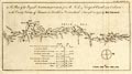 A Plan of the Proposed NAVIGABLE CANAL from the Leeds & Liverpool Canal near Eccleston in the County Palatine of Lancaster, to Kendal in Westmorland. Survey'd in 1772, by Robt. Whitworth. map type: Whitworth 1772 Size: wxh, sheet = 36.5x21.5cm; wxh, map = 311x166mm; scale: 1 to 260000? |
|||
|
gazetteer links
|
|||
|
|
-- Lancaster Canal | ||
|
|
|||
Lakes Guides menu.