 Gents Mag 1773 opp p.221

|

|
|
|

|
introduction | ||
|
|
list, 3rd qtr 18th century | ||
|
|
description | ||
|
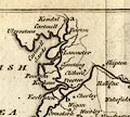
Gentleman's Magazine 1773 opp p.221
|
|||
|
canals England |
|||
Canals in England
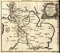 Canal map, uncoloured engraving, A General Plan of the Several Canals given in the Course of this Magazine, engraved by Thomas Bowen, published by the Gentleman's Magazine, 1773. A GENERAL PLAN of the several CANALS given in the Course of this Magazine map type: Bowen 1773 Size: wxh, sheet = 25x21cm; wxh, map = 205x174mm. The map includes England from Kendal in the north, St Asaph in the west, to just south of Reading.
 |
|||
|
gazetteer links
|
|||
|
|
-- Lancaster Canal | ||
|
|
|||
Lakes Guides menu.