Old Cumbria Gazetteer
 |
 |
|
||
| included in:- |
 road, Kendal to Skipton road, Kendal to Skipton |
|||
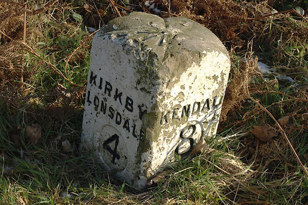
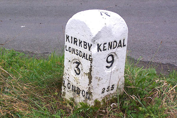
| road, Kendal to Kirkby Lonsdale | ||||
| Kendal to Kirkby Lonsdale | ||||
| Kirkby Lonsdale to Kendal | ||||
| A65 | ||||
| B6254 | ||||
| civil parish:- | Kendal (formerly Westmorland) | |||
| civil parish:- | Natland (formerly Westmorland) | |||
| civil parish:- | Stainton (formerly Westmorland) | |||
| civil parish:- | Preston Richard (formerly Westmorland) | |||
| civil parish:- | Preston Patrick (formerly Westmorland) | |||
| civil parish:- | Lupton (formerly Westmorland) | |||
| civil parish:- | Kirkby Lonsdale (formerly Westmorland) | |||
| civil parish:- | Old Hutton and Holmescales (formerly Westmorland) | |||
| county:- | Cumbria | |||
| locality type:- | road route | |||
| 10Km square:- | SD49 | |||
|
|
||||
| evidence:- | old map:- Bowen and Kitchin 1760 |
|||
| source data:- | Map, hand coloured engraving, A New Map of the Counties of
Cumberland and Westmoreland Divided into their Respective Wards,
scale about 4 miles to 1 inch, by Emanuel Bowen and Thomas
Kitchin et al, published by T Bowles, Robert Sayer, and John
Bowles, London, 1760.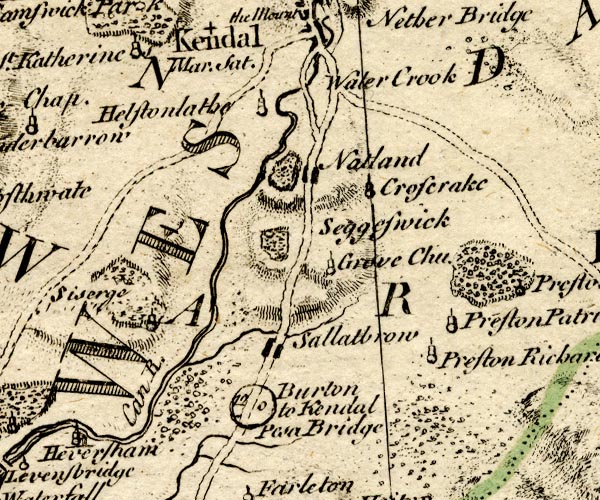 BO18SD48.jpg double line, dotted 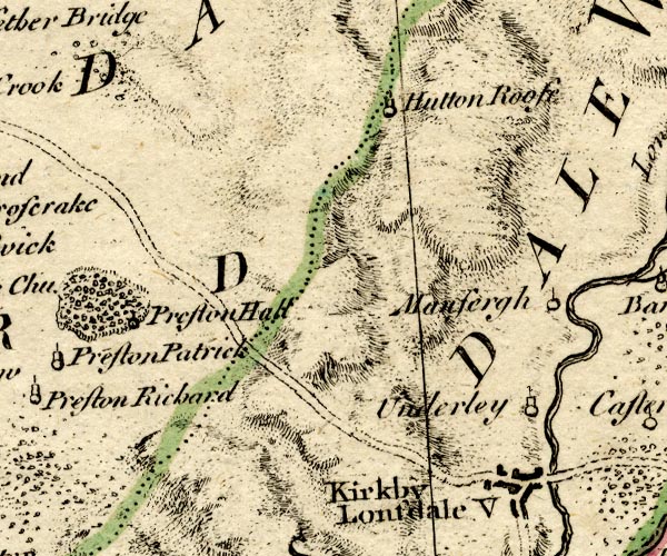 BO18SD58.jpg double line, dotted item:- Armitt Library : 2008.14.10 Image © see bottom of page |
|||
|
|
||||
| evidence:- | old map:- Jefferys 1770 (Wmd) |
|||
| source data:- | Map, 4 sheets, The County of Westmoreland, scale 1 inch to 1
mile, surveyed 1768, and engraved and published by Thomas
Jefferys, London, 1770. J5SD59SW.jpg 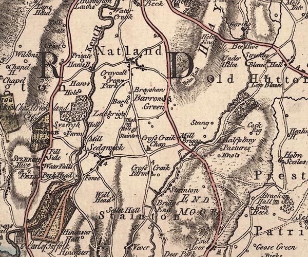 J5SD58NW.jpg 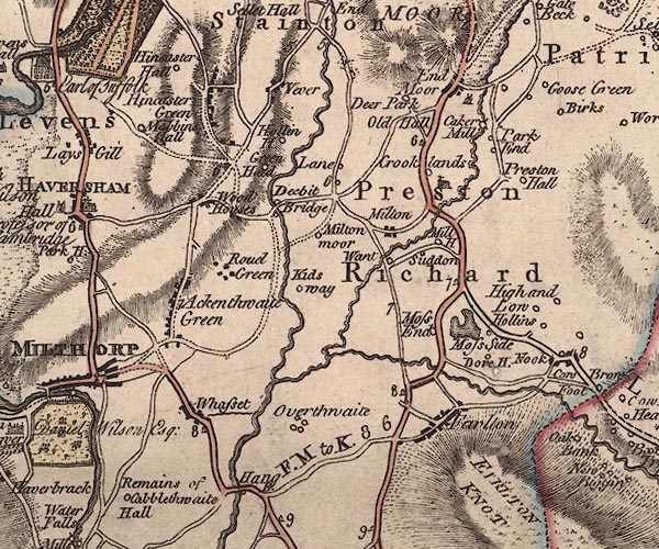 J5SD58SW.jpg 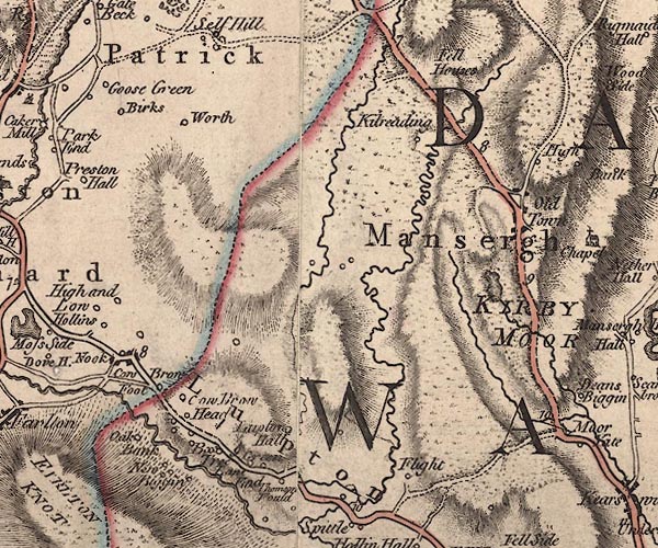 J5SD58SE.jpg 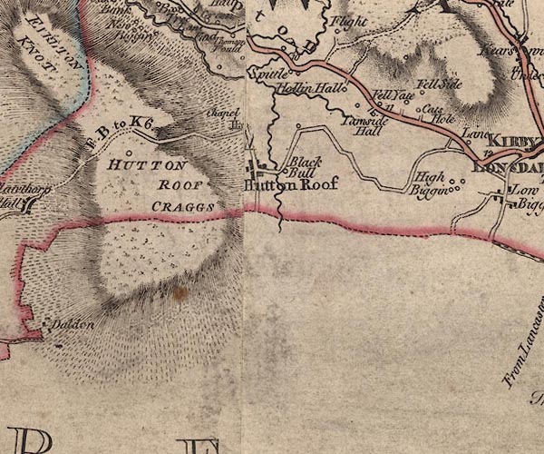 J5SD57NE.jpg 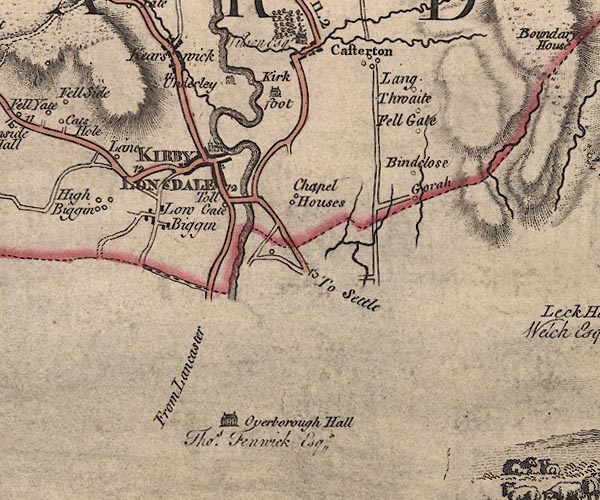 J5SD67NW.jpg double line; road, bold, main road, with mile numbers, through Lupton item:- National Library of Scotland : EME.s.47 Images © National Library of Scotland |
|||
|
|
||||
| evidence:- | old map:- Jefferys 1770 (Wmd) |
|||
| source data:- | Map, 4 sheets, The County of Westmoreland, scale 1 inch to 1
mile, surveyed 1768, and engraved and published by Thomas
Jefferys, London, 1770. J5SD59SW.jpg 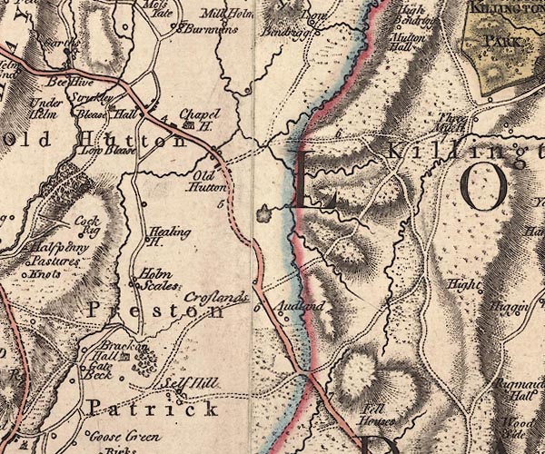 J5SD58NE.jpg J5SD58SE.jpg J5SD67NW.jpg double line; road, bold, main road, with mile numbers through Kearstwick item:- National Library of Scotland : EME.s.47 Images © National Library of Scotland |
|||
|
|
||||
| evidence:- | old text:- Pennant 1773 |
|||
| source data:- | Book, A Tour from Downing to Alston Moor, 1773, by Thomas
Pennant, published by Edward Harding, 98 Pall Mall, London, 1801. goto source Pennant's Tour 1773, page 119 "From hence [Kirkby Lonsdale] I crossed the country twelve miles, (an un-interesting ride,) to Kendal. ..." |
|||
|
|
||||
| evidence:- | descriptive text:- West 1778 (11th edn 1821) |
|||
| source data:- | Guide book, A Guide to the Lakes, by Thomas West, published by
William Pennington, Kendal, Cumbria once Westmorland, and in
London, 1778 to 1821. goto source Tour to the Caves in the West Riding of Yorkshire, late 18th century Page 239:- "..." "About six o'clock, one morning in June, we set off from Kendal, and, after travelling about a dozen miles along a good turnpike-road, over Endmoor and Crowbrow, we arrived at Kirkby-Lonsdale soon after eight. About the mid-way we left the little steep white mountain, Farlton-knot, on the right about a mile. ... There were several good mansion-houses by the road side, which, at the beginning of last century, were inhabited by a substantial set of yeomanry and country gentlemen, the most useful members of a community: they are now, however, mostly let out to farmers: the desire of improving their fortunes in trade, or the pleasure of living in towns, have induced the owners to leave them - reverses of fortune, or new attachments, have caused many to sell them, after they had been continued many centuries in their families." |
|||
|
|
||||
| evidence:- | old map:- Cary 1789 (edn 1805) |
|||
| source data:- | Map, uncoloured engraving, Westmoreland, scale about 2.5 miles
to 1 inch, by John Cary, London, 1789; edition 1805. CY24SD59.jpg 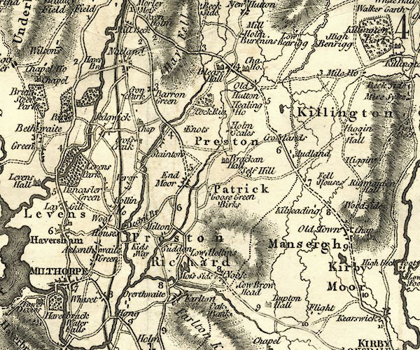 CY24SD58.jpg 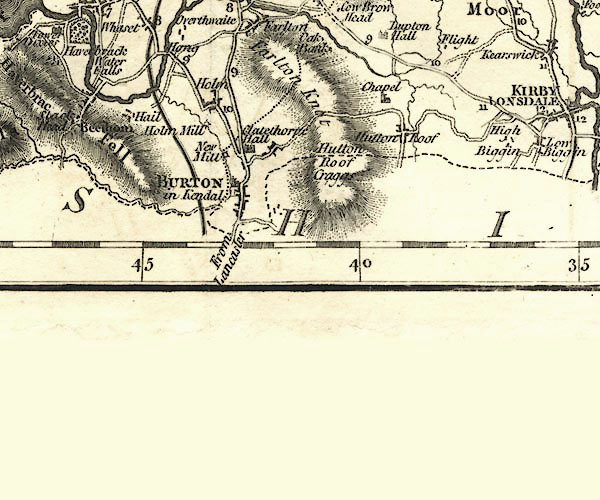 CY24SD57.jpg double line, bold light, numbered miles; main road 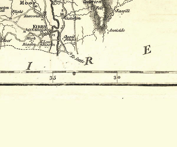 CY24SD67.jpg double line, bold light, numbered miles; main road two routes item:- JandMN : 129 Image © see bottom of page |
|||
|
|
||||
| evidence:- | road map:- Cary 1790 (Wmd/edn 1792) |
|||
| source data:- | Road map, hand coloured engraving, Westmoreland, scale about
11.5 miles to 1 inch, by John Cary, 181 Strand, London, 1790,
edn 1792. click to enlarge click to enlargeCY16.jpg double line, with road distances from Kendal item:- JandMN : 44 Image © see bottom of page |
|||
|
|
||||
| evidence:- | road book:- Cary 1798 (2nd edn 1802) |
|||
| source data:- | Road book, itineraries, Cary's New Itinerary, by John Cary, 181
Strand, London, 2nd edn 1802. goto source click to enlarge click to enlargeC38267.jpg page 267-268 "Near 2 Miles beyond Barrows Green, on r. a T.R. to Kirkby Lonsdale." goto source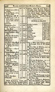 click to enlarge click to enlargeC38333.jpg page 333-334 "[LONDON to Kendal, through Halifax]" part of item:- JandMN : 228.1 Image © see bottom of page |
|||
|
|
||||
| evidence:- | old map:- Cooke 1802 |
|||
| source data:- | Map, Westmoreland ie Westmorland, scale about 12 miles to 1
inch, by George Cooke, 1802, published by Sherwood, Jones and
Co, Paternoster Road, London, 1824. click to enlarge click to enlargeGRA1Wd.jpg double line, light dark solid; road AND double line, light dark dotted; unfenced road item:- Hampshire Museums : FA2000.62.4 Image © see bottom of page |
|||
|
|
||||
| evidence:- | old map:- Laurie and Whittle 1806 |
|||
| source data:- | Road map, Completion of the Roads to the Lakes, scale about 10
miles to 1 inch, by Nathaniel Coltman? 1806, published by Robert
H Laurie, 53 Fleet Street, London, 1834. click to enlarge click to enlargeLw18.jpg bold line; 'Principal Travelling Roads' item:- private collection : 18.18 Image © see bottom of page |
|||
|
|
||||
| evidence:- | old map:- Laurie and Whittle 1806 |
|||
| source data:- | Road map, Continuation of the Roads to Glasgow and Edinburgh,
scale about 10 miles to 1 inch, by Nathaniel Coltman? 1806,
published by Robert H Laurie, 53 Fleet Street, London, 1834. click to enlarge click to enlargeLw21.jpg bold line; 'Principal Travelling Roads' item:- private collection : 18.21 Image © see bottom of page |
|||
|
|
||||
| evidence:- | old map:- Cooper 1808 |
|||
| source data:- | Map, hand coloured engraving, Westmoreland ie Westmorland, scale
about 9 miles to 1 inch, by H Cooper, 1808, published by R
Phillips, Bridge Street, Blackfriars, London, 1808. click to enlarge click to enlargeCOP4.jpg double line; road item:- Dove Cottage : 2007.38.53 Image © see bottom of page |
|||
|
|
||||
| evidence:- | old map:- Wallis 1810 (Wmd) |
|||
| source data:- | Road map, Westmoreland, scale about 19 miles to 1 inch, by James
Wallis, 77 Berwick Street, Soho, 1810, published by W Lewis,
Finch Lane, London, 1835? click to enlarge click to enlargeWAL5.jpg double line, light bold; 'Turnpike Road' item:- JandMN : 63 Image © see bottom of page |
|||
|
|
||||
| evidence:- | old map:- Hall 1820 (Wmd) |
|||
| source data:- | Map, hand coloured engraving, Westmoreland ie Westmorland, scale
about 14.5 miles to 1 inch, by Sidney Hall, London, 1820,
published by Samuel Leigh, 18 Strand, London, 1820-31. click to enlarge click to enlargeHA18.jpg single line, solid; minor road; Kendal, Blease Hall, Old Hutton, Goslands - Crosslands, Mansergh, Kirkby Lonsdale OR Kendal, Preston Richard, Nook, Catshole, Kirkby Lonsdale item:- Armitt Library : 2008.14.58 Image © see bottom of page |
|||
|
|
||||
| evidence:- | old itinerary:- Tinsley 1877 (Roads/Cum) |
|||
| source data:- | Itinerary, route 7, London to Whitehaven via the Lake Districts, including from Settle,
Lancashire; through Kirkby Lonsdale, Kendal, Ambleside, Westmorland; then Keswick,
Cockermouth to Whitehaven, Cumberland, published by Tinsley Bros, 8 Catherine Street,
Strand, London, 1877.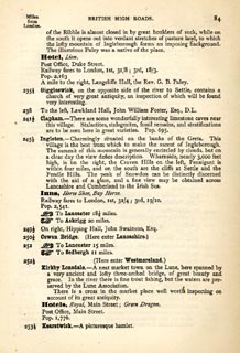 click to enlarge click to enlargeTLY184.jpg pp.71-91 in British High Roads, North and North Eastern Routes; pp.84-91. printed at p.71:- "... / ROUTE VII. - LONDON to WHTEHAVEN via THE LAKE / DISTRICTS. (See Maps 65 to 80.) / Hitchin (as per Route I.) 34, Shefford 41, Bedford 50, Higham-Ferrers, / 64¾, Kettering 74½, Rockingham 83¼, Uppingham 88¾, Oakham, / 94¾, Melton Mowbray 104¾, Nottingham 123¼, Rotherham 159¼, / Barnsley 171¾, Huddersfield 188¾, Halifax 196¾, Keighley 208¾, / Skipton 218¾, Settle 234¾, Kirkby Lonsdale 252½, Kendal 264½, / Ambleside 278½, Keswick 293½, Cockermouth 305½, Whitehaven / 319½. / ..." 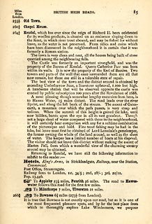 click to enlarge click to enlargeTLY185.jpg item:- private collection : 270.2 Image © see bottom of page |
|||
|
|
||||
| evidence:- | old strip map:- Tinsley 1877 (Roads/Cum) |
|||
| source data:- | Strip map, road map, part of London to Whitehaven, including from before Kirkby Lonsdale
through Kendal, Windermere to beyond Ambleside, Westmorland, published by Tinsley
Bros, 8 Catherine Street, Strand, London, 1877.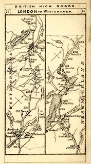 click to enlarge click to enlargeTLY1M4.jpg Map pp.77-78 in British High Roads, North and North Eastern Routes. printed at top:- "BRITISH HIGH ROADS / 77 LONDON TO WHITEHAVEN. 78" item:- private collection : 270.6 Image © see bottom of page |
|||
|
|
||||
| evidence:- | gradient diagram:- Gall and Inglis 1890s-1900s (Roads) |
|||
| source data:- | Contour Road Book of England, Northern Division, by Harry R G Inglis, published by
Gall and Inglis, 25 Paternoster Square, London and Edinburgh, 1898.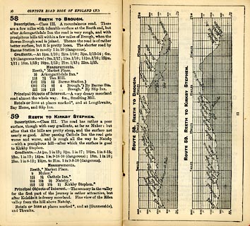 click to enlarge click to enlargeIG5058.jpg Itinerary, with gradient diagram, route 103, Skipton to Kendal, Yorkshire and Westmorland, 1898. item:- JandMN : 763.7 Image © see bottom of page |
|||
|
|
||||
| evidence:- | gradient diagram:- Gall and Inglis 1890s-1900s (Roads) |
|||
| source data:- | Contour Road Book of England, Northern Division, by Harry R G Inglis, published by
Gall and Inglis, 25 Paternoster Square, London and Edinburgh, 1898.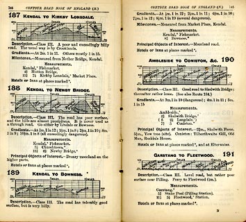 click to enlarge click to enlargeIG5187.jpg Itinerary, with gradient diagram, routes 187, Kendal to Kirkby Lonsdale, 188, Kendal to Newby Bridge, 189, Kendal to Bowness, and 190, Ambleside to Coniston etc, Westmorland and Lancashire, 1898. item:- JandMN : 763.19 Image © see bottom of page |
|||
|
|
||||
| evidence:- | gradient diagram:- Pratt 1905 (edn 1915) |
|||
| source data:- | Gradient diagram, Doncaster to Kendal, in Pratt's Road Atlas of England and Wales
... by George Philip and Son, 32 Fleet Street, London, 1905, published by Anglo-American
Oil Co, 36-38 Queen Anne's Gate, Westminster, London, 1915.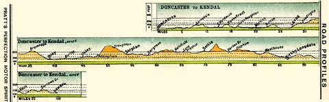 click to enlarge click to enlargePRA1G2.jpg "DONCASTER to KENDAL" item:- Hampshire Museums : FA2001.138 Image © see bottom of page |
|||
|
|
||||
| evidence:- | old itinerary:- Johnson 1908 (Roads/Cum) |
|||
| source data:- | Itinerary, Route 39 in Roads Made Easy by Picture and Pen, Doncaster to Glasgow, through
Skipton, by Claude Johnson, edited by Lord Montagu, published by The Car Illustrated,
168 Piccadilly, London, 1908. click to enlarge click to enlargeJS5056.jpg pp.49-56 in the road book, Roads Made Easy by Picture and Pen, vol.3. printed at beginning, p.49:- "ROUTE 39. / DONCASTER, via Ferrybridge, Collingham (31¼), Otley (44¾), Ilkley (50¾), Skipton (59¾), Hellifield (69¼), Ingleton (87), Kirkby Lonsdale (92¾), Kendal (104), Carlisle (149½) to GLASGOW (244¼)" item:- private collection : 268.6 Image © see bottom of page |
|||
|
|
||||
| evidence:- | old itinerary:- Johnson 1908 (Roads/Cum) |
|||
| source data:- | Itinerary, Route 39 reverse in Roads Made Easy by Picture and Pen, Glasgow to Doncaster,
through Skipton, by Claude Johnson, edited by Lord Montagu, published by The Car Illustrated,
168 Piccadilly, London, 1908. click to enlarge click to enlargeJS5057.jpg pp.57-65 in the road book, Roads Made Easy by Picture and Pen, vol.3. printed at beginning, p.57:- "ROUTE 39. Reverse. / GLASGOW via Carlisle (95), Kendal (139½), Kirkby Lonsdale (151½), Ingleton (157¼), Hellifield (175), Skipton (184½), Ilkley (193½), Otley (199½), Junction with North Road (214½) to DONCASTER (244 1/34)."  click to enlarge click to enlargeJS5058.jpg item:- private collection : 268.7 Image © see bottom of page |
|||
|
|
||||
 Act of Parliament Act of Parliament |
||||
|
|
||||
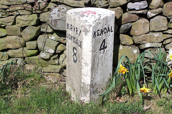
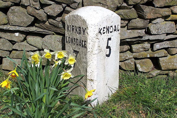
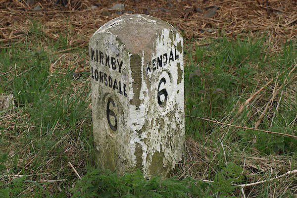
| places:- | Kendal Natland Stainton Lupton Kirkby Lonsdale |
|||
|
|
||||
| places:- | alternative route Kendal Old Hutton Old Town, Mansergh Kearstwick, Kirkby Lonsdale Kirkby Lonsdale |
|||
|
|
||||
| places:- | alternative route Kendal Levens Bridge, Levens Lupton Kirkby Lonsdale |
|||
|
|
||||
| places:- |
|
|||
|
||||
|
||||
|
||||
|
||||
|
||||
|
||||
|
||||
|
||||
|
||||
|
||||
|
||||
|
||||
|
||||
|
||||
|
||||
Lakes Guides menu.