 Old Cumbria Gazetteer
 |
 |
|
| Levens Bridge, Levens | ||
| Levens Bridge | ||
| site name:- | Kent, River | |
| civil parish:- | Levens (formerly Westmorland) | |
| county:- | Cumbria | |
| locality type:- | bridge | |
| coordinates:- | SD49618522 | |
| 1Km square:- | SD4985 | |
| 10Km square:- | SD48 | |
|
|
||
 BJR02.jpg (taken 2.8.2005) |
||
|
|
||
| evidence:- | old map:- OS County Series (Wmd 42 7) placename:- Levens Bridge |
|
| source data:- | Maps, County Series maps of Great Britain, scales 6 and 25
inches to 1 mile, published by the Ordnance Survey, Southampton,
Hampshire, from about 1863 to 1948. |
|
|
|
||
| evidence:- | old map:- Saxton 1579 placename:- Levens Bridge |
|
| source data:- | Map, hand coloured engraving, Westmorlandiae et Cumberlandiae Comitatus ie Westmorland
and Cumberland, scale about 5 miles to 1 inch, by Christopher Saxton, London, engraved
by Augustinus Ryther, 1576, published 1579-1645.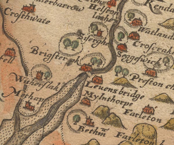 Sax9SD48.jpg "Levens bridge" Over the River Kent. item:- private collection : 2 Image © see bottom of page |
|
|
|
||
| evidence:- | old map:- Keer 1605 |
|
| source data:- | Map, hand coloured engraving, Westmorland and Cumberland, scale
about 16 miles to 1 inch, probably by Pieter van den Keere, or
Peter Keer, about 1605 edition perhaps 1676. click to enlarge click to enlargeKER8.jpg "" double line across a stream; bridge item:- Dove Cottage : 2007.38.110 Image © see bottom of page |
|
|
|
||
| evidence:- | old map:- Speed 1611 (Wmd) placename:- Levens Bridge |
|
| source data:- | Map, hand coloured engraving, The Countie Westmorland and
Kendale the Cheif Towne, scale about 2.5 miles to 1 inch, by
John Speed, 1610, published by George Humble, Popes Head Alley,
London, 1611-12.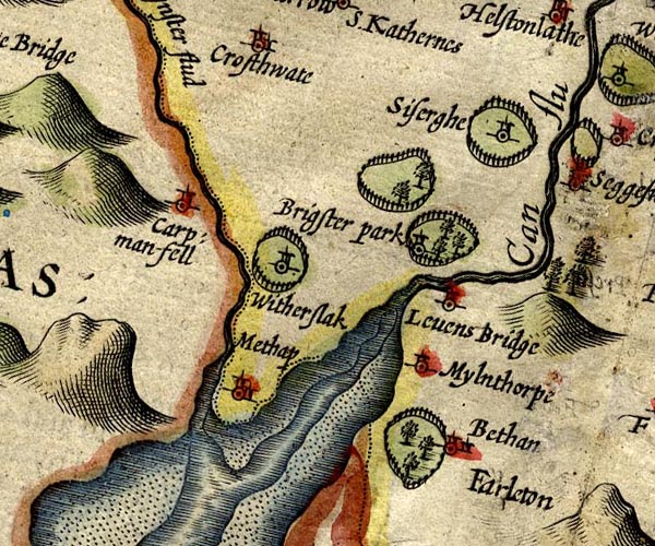 SP14SD48.jpg "Levens Bridge" circle, tower; no bridge marked item:- Armitt Library : 2008.14.5 Image © see bottom of page |
|
|
|
||
| evidence:- | table of distances:- Simons 1635 placename:- Levens Bridge |
|
| source data:- | Table of distances, uncoloured engraving, Westmerland ie
Westmorland, with a thumbnail map, scale about 42 miles to 1
inch, by Mathew Simons, published in A Direction for the English
Traviller, 1635.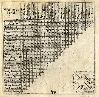 click to enlarge click to enlargeSIM3.jpg "Levens bridge S" and tabulated distances item:- private collection : 50.39 Image © see bottom of page |
|
|
|
||
| evidence:- | old map:- Jansson 1646 placename:- Levens Bridge |
|
| source data:- | Map, hand coloured engraving, Cumbria and Westmoria, ie
Cumberland and Westmorland, scale about 3.5 miles to 1 inch, by
John Jansson, Amsterdam, Netherlands, 1646.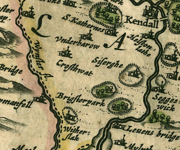 JAN3SD48.jpg "[Levens bridge]" No bridge symbol; the label is used for Levens Hall. item:- JandMN : 88 Image © see bottom of page |
|
|
|
||
| evidence:- | old map:- Morden 1695 (Wmd) placename:- Levens Bridge |
|
| source data:- | Map, hand coloured engraving, Westmorland, scale about 2.5 miles to 1 inch, by Robert
Morden, published by Abel Swale, the Unicorn, St Paul's Churchyard, Awnsham, and John
Churchill, the Black Swan, Paternoster Row, London, 1695.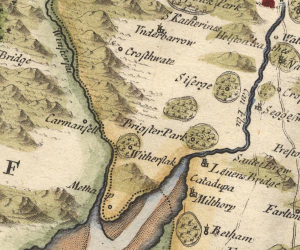 MD10SD48.jpg "Levens Bridge" Circle, building and tower. item:- JandMN : 24 Image © see bottom of page |
|
|
|
||
| evidence:- | old map:- Simpson 1746 map (Wmd) placename:- Levens Bridge |
|
| source data:- | Map, uncoloured engraving, Westmorland, scale about 8 miles to 1
inch, printed by R Walker, Fleet Lane, London, 1746. SMP2SDP.jpg "Levens B." item:- Dove Cottage : 2007.38.59 Image © see bottom of page |
|
|
|
||
| evidence:- | old map:- Bowen and Kitchin 1760 placename:- Levensbridge |
|
| source data:- | Map, hand coloured engraving, A New Map of the Counties of
Cumberland and Westmoreland Divided into their Respective Wards,
scale about 4 miles to 1 inch, by Emanuel Bowen and Thomas
Kitchin et al, published by T Bowles, Robert Sayer, and John
Bowles, London, 1760. BO18SD37.jpg "Levensbridge" double line across the Kent, also a circle and line item:- Armitt Library : 2008.14.10 Image © see bottom of page |
|
|
|
||
| evidence:- | old map:- Jefferys 1770 (Wmd) |
|
| source data:- | Map, 4 sheets, The County of Westmoreland, scale 1 inch to 1
mile, surveyed 1768, and engraved and published by Thomas
Jefferys, London, 1770. J5SD48NE.jpg double line, road, across a stream; bridge item:- National Library of Scotland : EME.s.47 Image © National Library of Scotland |
|
|
|
||
| evidence:- | old text:- Camden 1789 (Gough Additions) |
|
| source data:- | Book, Britannia, or A Chorographical Description of the Flourishing Kingdoms of England,
Scotland, and Ireland, by William Camden, 1586, translated from the 1607 Latin edition
by Richard Gough, published London, 1789. goto source goto sourcePage 153:- "..." "At Levens, ... is a fair stone bridge over the Kent, ..." |
|
|
|
||
| evidence:- | old map:- Cary 1789 (edn 1805) |
|
| source data:- | Map, uncoloured engraving, Westmoreland, scale about 2.5 miles
to 1 inch, by John Cary, London, 1789; edition 1805. CY24SD48.jpg road across a stream; bridge over the Kent item:- JandMN : 129 Image © see bottom of page |
|
|
|
||
| evidence:- | old map:- Cooper 1808 |
|
| source data:- | Map, hand coloured engraving, Westmoreland ie Westmorland, scale
about 9 miles to 1 inch, by H Cooper, 1808, published by R
Phillips, Bridge Street, Blackfriars, London, 1808. click to enlarge click to enlargeCOP4.jpg road across stream; bridge? item:- Dove Cottage : 2007.38.53 Image © see bottom of page |
|
|
|
||
| evidence:- | old map:- Otley 1818 |
|
| source data:- | Map, uncoloured engraving, The District of the Lakes,
Cumberland, Westmorland, and Lancashire, scale about 4 miles to
1 inch, by Jonathan Otley, 1818, engraved by J and G Menzies,
Edinburgh, Scotland, published by Jonathan Otley, Keswick,
Cumberland, et al, 1833. OT02SD48.jpg Implied by a road crossing the stream. item:- JandMN : 48.1 Image © see bottom of page |
|
|
|
||
| evidence:- | :- Hullmandel 1826 placename:- Levens Bridge |
|
| source data:- | 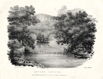 click to enlarge click to enlargeHUL106.jpg Print, uncoloured lithograph, Levens Bridge, with Whitbarrow Scar in the distance, Levens, Westmorland, drawn by Miss I Cropper and Miss S Atkins, published by Charles Hullmandel, London, 1826. "Drawn on Stone by I.C & S.A. / Printed by C. Hullmandel. / LEVENS BRIDGE, / WITH WHITBARROW SCAR IN THE DISTANCE." item:- Armitt Library : ALMA370.6 Image © see bottom of page |
|
|
|
||
| evidence:- | old print:- Bradley 1901 placename:- Levens Bridge |
|
| source data:- | Print, uncoloured lithograph, Levens Bridge, Levens, Westmorland, by Joseph Pennell,
published by Macmillan and Co, London, 1901.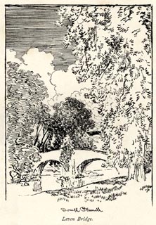 click to enlarge click to enlargeBRL187.jpg On page 323 of Highways and Byways in the Lake District, by A G Bradley. printed at lower centre:- "Joseph Pennell" printed at bottom:- "Levens Bridge." item:- JandMN : 464.87 Image © see bottom of page |
|
|
|
||
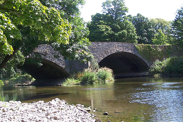
| evidence:- | database:- Listed Buildings 2010 placename:- Levens Bridge |
|
| source data:- | courtesy of English Heritage "LEVENS BRIDGE / / A6 / LEVENS / SOUTH LAKELAND / CUMBRIA / II / 75543 / SD4960785224" |
|
| source data:- | courtesy of English Heritage "Bridge. Probably C17, widened and extensively repaired and rebuilt during C18 and C19. Limestone rubble with roughly-cut voussoirs. 2 arches with cutwaters between. Flat sandstone coping to parapets. Attached at South-West corner to walls and gatepiers at entrance to Levens Hall (q.v.). Further information: CURWEN J.F. Records of Kendal Volume III pub. Titus Wilson 1920." |
|
|
|
||
Lakes Guides menu.