 Old Cumbria Gazetteer
 |
 |
|
| milestone, Old Hutton and Holmescales | ||
| site name:- | road, Kendal to Kirkby Lonsdale | |
| civil parish:- | Old Hutton and Holmescales (formerly Westmorland) | |
| county:- | Cumbria | |
| locality type:- | milestone | |
| coordinates:- | SD56598830 | |
| 1Km square:- | SD5688 | |
| 10Km square:- | SD58 | |
|
|
||
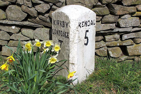 BLV10.jpg Inscribed stone:- "KIRKBY LONSDALE 7 / KENDAL 5" (taken 9.4.2006) |
||
|
|
||
| evidence:- | old map:- OS County Series |
|
| source data:- | Maps, County Series maps of Great Britain, scales 6 and 25
inches to 1 mile, published by the Ordnance Survey, Southampton,
Hampshire, from about 1863 to 1948. "M.S. KENDAL .. 5 KIRKBY LONSDALE .. 7" |
|
|
|
||
| evidence:- | database:- Listed Buildings 2010 |
|
| source data:- | courtesy of English Heritage "MILESTONE ON EAST SIDE OF ROAD 100 YARDS NORTH-EAST OF HUTTON YEAT / / B6254 / OLD HUTTON AND HOLMESCALES / SOUTH LAKELAND / CUMBRIA / II / 76706 / SD5659488297" |
|
| source data:- | courtesy of English Heritage "Milestone. Possibly early C19. Monolithic stone c.2 ft high and triangular in plan with domical top and ruled dressing. Painted white with sans-serif lettering and numbers picked out in black: KIRKBY LONSDALE 7 (north face); KENDAL 5 (south face)." |
|
|
|
||
 Lakes Guides menu.