 Old Cumbria Gazetteer
 |
 |
|
| Nether Bridge Turnpike, Kendal | ||
| Nether Bridge Turnpike | ||
| site name:- | road, Lancaster to Kendal E | |
| site name:- | road, Kendal to Kirkby Lonsdale | |
| locality:- | Kendal | |
| civil parish:- | Kendal (formerly Westmorland) | |
| county:- | Cumbria | |
| locality type:- | toll gate (site) | |
| coordinates:- | SD51749188 (about) | |
| 1Km square:- | SD5191 | |
| 10Km square:- | SD59 | |
| references:- | OS County Series |
|
|
|
||
| evidence:- | old map:- OS County Series (Wmd 38 12) |
|
| source data:- | Maps, County Series maps of Great Britain, scales 6 and 25
inches to 1 mile, published by the Ordnance Survey, Southampton,
Hampshire, from about 1863 to 1948. "Nether Bridge T.P." at a fork; gates on both roads, and a building |
|
|
|
||
| evidence:- | old map:- Jefferys 1770 |
|
| source data:- | Map, 4 sheets, The County of Westmoreland, scale 1 inch to 1
mile, surveyed 1768, and engraved and published by Thomas
Jefferys, London, 1770.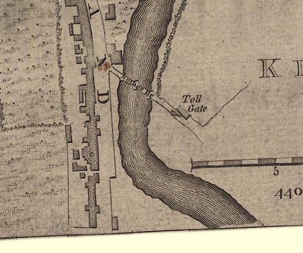 J55191U.jpg "Toll Gate" building/s and a gate across the road item:- National Library of Scotland : EME.s.47 Image © National Library of Scotland |
|
|
|
||
| evidence:- | probably old map:- Jefferys 1770 (Wmd) |
|
| source data:- | Map, 4 sheets, The County of Westmoreland, scale 1 inch to 1
mile, surveyed 1768, and engraved and published by Thomas
Jefferys, London, 1770. J5SD59SW.jpg "Toll Gate" circle, by Nether Bridge item:- National Library of Scotland : EME.s.47 Image © National Library of Scotland |
|
|
|
||
 Lakes Guides menu.