 Old Cumbria Gazetteer
 |
 |
|
| milestone, Preston Patrick | ||
| site name:- | road, Kendal to Kirkby Lonsdale | |
| locality:- | Nook | |
| civil parish:- | Preston Patrick (formerly Westmorland) | |
| county:- | Cumbria | |
| locality type:- | milestone | |
| coordinates:- | SD54558200 | |
| 1Km square:- | SD5482 | |
| 10Km square:- | SD58 | |
|
|
||
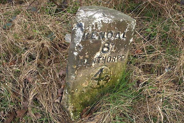 BOT64.jpg Inscribed stone:- "KENDAL / 8 / MILNTHORPE / 4½" (taken 7.3.2008) 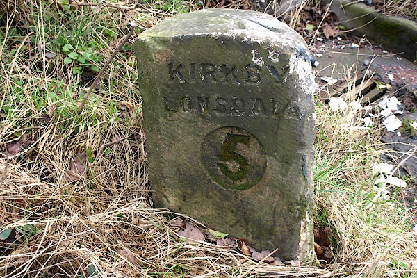 BOT65.jpg Inscribed stone:- "KIRKBY / LONSDALE / 5" (taken 7.3.2008) |
||
|
|
||
| evidence:- | old map:- OS County Series (Wmd 43 13) |
|
| source data:- | Maps, County Series maps of Great Britain, scales 6 and 25
inches to 1 mile, published by the Ordnance Survey, Southampton,
Hampshire, from about 1863 to 1948. "M.S. Kendal .. 8 Kirkby Lonsdale .. 5 Milnthorpe .. 4 1/2" |
|
|
|
||
| evidence:- | database:- Listed Buildings 2010 |
|
| source data:- | courtesy of English Heritage "MILESTONE APPROXIMATELY 75 METRES NORTH OF SUMMERDALE HOUSE / / A65 / PRESTON PATRICK / SOUTH LAKELAND / CUMBRIA / II / 76615 / SD5455082000" |
|
| source data:- | courtesy of English Heritage "Milestone. Probably early C19. Limestone. Upright post with flat top and deep chamfers to front corners. Painted black and white with deeply-incised sans-serif lettering and numbers in sunken oval panels:-" "KIRKBY / LONSDALE / 5" "to West and" "KENDAL / 8 / MILNTHORPE / 5" "to East." |
|
|
|
||
 Lakes Guides menu.