Old Cumbria Gazetteer
 |
 |
|
||
| included in:- |
 road, Carlisle to Tynemouth road, Carlisle to Alston road, Carlisle to Tynemouth road, Carlisle to Alston |
|||
| road, Carlisle to Brampton N | ||||
| A689 | ||||
| civil parish:- | Carlisle (formerly Cumberland) | |||
| civil parish:- | Stanwix Rural (formerly Cumberland) | |||
| civil parish:- | Irthington (formerly Cumberland) | |||
| civil parish:- | Brampton (formerly Cumberland) | |||
| county:- | Cumbria | |||
| locality type:- | road route | |||
| 10Km square:- | NY35 | |||
| 10Km square:- | NY45 | |||
| 10Km square:- | NY56 | |||
| SummaryText:- | via Crosby, Northerly route | |||
|
|
||||
| evidence:- | old map:- Bowen and Kitchin 1760 |
|||
| source data:- | Map, hand coloured engraving, A New Map of the Counties of
Cumberland and Westmoreland Divided into their Respective Wards,
scale about 4 miles to 1 inch, by Emanuel Bowen and Thomas
Kitchin et al, published by T Bowles, Robert Sayer, and John
Bowles, London, 1760.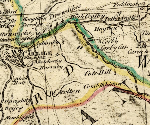 BO18NY45.jpg north and south, both double line, dotted 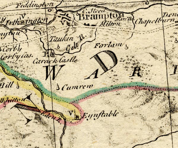 BO18NY55.jpg north and south, both double line, dotted item:- Armitt Library : 2008.14.10 Image © see bottom of page |
|||
|
|
||||
| evidence:- | old map:- Donald 1774 (Cmd) |
|||
| source data:- | Map, hand coloured engraving, 3x2 sheets, The County of Cumberland, scale about 1
inch to 1 mile, by Thomas Donald, engraved and published by Joseph Hodskinson, 29
Arundel Street, Strand, London, 1774. double line, solid or dotted, with a dot or milestone and number at 1 mile intervals, tinted red; turnpike road  D4NY45NW.jpg from Scots Gate and over the Eden 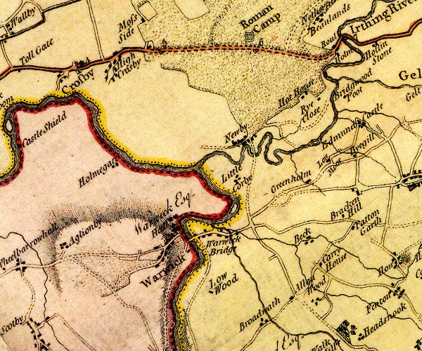 D4NY45NE.jpg 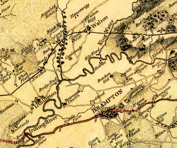 D4NY56SW.jpg item:- Carlisle Library : Map 2 Images © Carlisle Library |
|||
|
|
||||
| evidence:- | road map:- Cary 1790 (Cmd/edn 1789) |
|||
| source data:- | Road map, hand coloured engraving, Cumberland, scale about 15
miles to 1 inch, by John Cary, 181 Strand, London, 1790, edn
1789.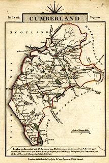 click to enlarge click to enlargeCY47.jpg double line, with road distances from Carlisle item:- JandMN : 419 Image © see bottom of page |
|||
|
|
||||
| evidence:- | road book:- Cary 1798 (2nd edn 1802) |
|||
| source data:- | Road book, itineraries, Cary's New Itinerary, by John Cary, 181
Strand, London, 2nd edn 1802. goto source click to enlarge click to enlargeC38267.jpg page 267-268 "Cross the River Eden; and on r. a T.R. to Newcastle." goto source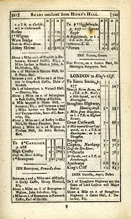 click to enlarge click to enlargeC38321.jpg page 321-322 item:- JandMN : 228.1 Image © see bottom of page |
|||
|
|
||||
| evidence:- | road book:- Cary 1798 (2nd edn 1802) |
|||
| source data:- | Road book, itineraries, Cary's New Itinerary, by John Cary, 181
Strand, London, 2nd edn 1802. goto source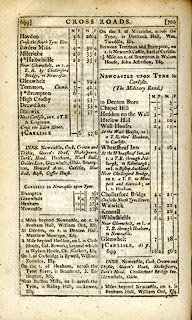 click to enlarge click to enlargeC38699.jpg page 699-700 "NEWCASTLE UPON TYNE to Carlisle, by Hexham (The usual Carriage Road.)" part of item:- JandMN : 228.2 Image © see bottom of page |
|||
|
|
||||
| evidence:- | old map:- Cooke 1802 |
|||
| source data:- | Map, Cumberland, scale about 15.5 miles to 1 inch, by George
Cooke, 1802, bound in Gray's New Book of Roads, 1824, published
by Sherwood, Jones and Co, Paternoster Road, London, 1824. click to enlarge click to enlargeGRA1Cd.jpg double line, light dark solid; road item:- Hampshire Museums : FA2000.62.2 Image © see bottom of page |
|||
|
|
||||
| evidence:- | old map:- Cooper 1808 |
|||
| source data:- | Map, uncoloured engraving, Cumberland, scale about 10.5 miles to
1 inch, drawn and engraved by Cooper, published by R Phillips,
Bridge Street, Blackfriars, London, 1808. click to enlarge click to enlargeCOP3.jpg double line; road item:- JandMN : 86 Image © see bottom of page |
|||
|
|
||||
| evidence:- | old map:- Wallis 1810 (Cmd) |
|||
| source data:- | Road map, hand coloured engraving, Cumberland, scale about 16
miles to 1 inch, by James Wallis, 77 Berwick Stree, Soho,
London, 1810. click to enlarge click to enlargeWL13.jpg double line, light bold; 'Turnpike Road' item:- Dove Cottage : 2009.81.10 Image © see bottom of page |
|||
|
|
||||
| evidence:- | old map:- Ford 1839 map |
|||
| source data:- | Map, uncoloured engraving, Map of the Lake District of
Cumberland, Westmoreland and Lancashire, scale about 3.5 miles
to 1 inch, published by Charles Thurnam, Carlisle, and by R
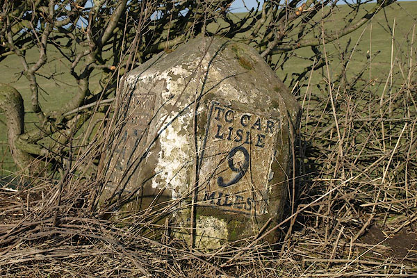
Groombridge, 5 Paternoster Row, London, 3rd edn 1843.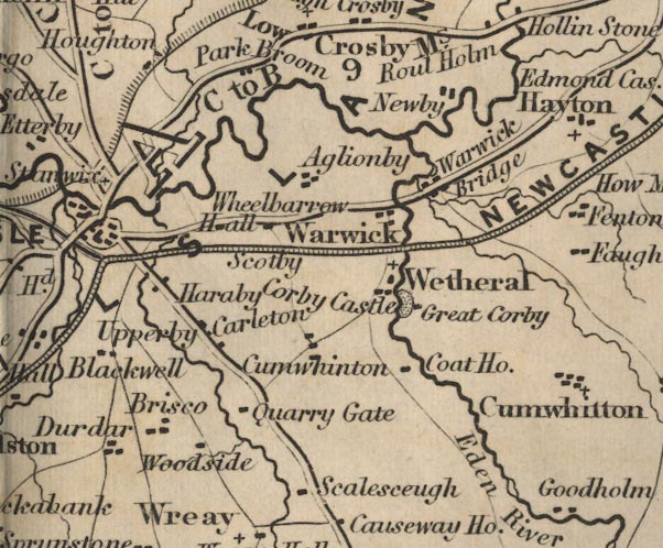 FD02NY45.jpg 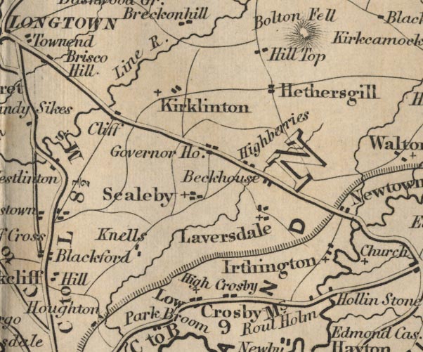 FD02NY46.jpg 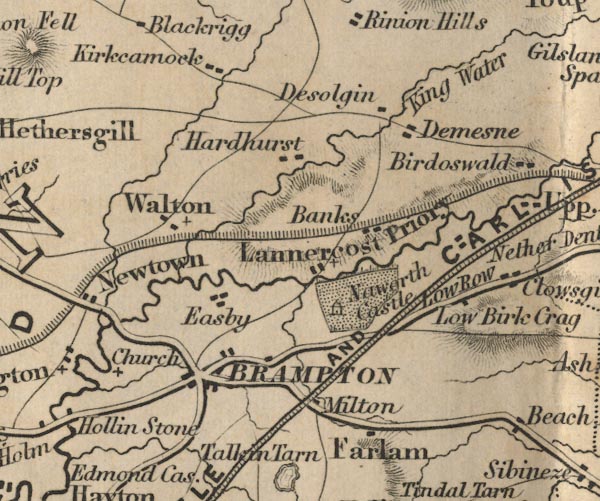 FD02NY56.jpg "C to B 9 Ms." item:- JandMN : 100.1 Image © see bottom of page |
|||
|
|
||||
| evidence:- | descriptive text:- Ford 1839 (3rd edn 1843) |
|||
| source data:- | Guide book, A Description of Scenery in the Lake District, by
Rev William Ford, published by Charles Thurnam, Carlisle, by W
Edwards, 12 Ave Maria Lane, Charles Tilt, Fleet Street, William
Smith, 113 Fleet Street, London, by Currie and Bowman,
Newcastle, by Bancks and Co, Manchester, by Oliver and Boyd,
Edinburgh, and by Sinclair, Dumfries, 1839. goto source Page 108:- "... the military way leading to Brampton: this road runs parallel to the Roman Wall, which lies rather more to the north or left hand, along a higher ridge of land. The first village you pass through is Crosby, whose plain unpretending church stands by the way-side. Two miles further, at a cross-road, is a Roman Castrum, planted with fir-trees. Leaving the main road here, ..." |
|||
|
|
||||
| evidence:- | old map:- Garnett 1850s-60s H |
|||
| source data:- | Map of the English Lakes, in Cumberland, Westmorland and
Lancashire, scale about 3.5 miles to 1 inch, published by John
Garnett, Windermere, Westmorland, 1850s-60s.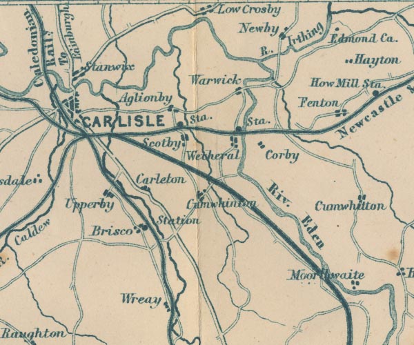 GAR2NY45.jpg double line, bold light, major road item:- JandMN : 82.1 Image © see bottom of page |
|||
|
|
||||
| evidence:- | gradient diagram:- Gall and Inglis 1890s-1900s (Roads) |
|||
| source data:- | Contour Road Book of England, Northern Division, by Harry R G Inglis, published by
Gall and Inglis, 25 Paternoster Square, London and Edinburgh, 1898.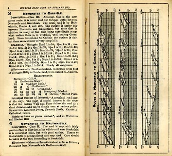 click to enlarge click to enlargeIG5003.jpg Itinerary, with gradient diagram, route 3, Newcastle to Carlisle, Northumberland and Cumberland, 1898. item:- JandMN : 763.2 Image © see bottom of page |
|||
|
|
||||
| evidence:- | old map:- Bell 1892 |
|||
| source data:- | Map, colour lithograph, Road Map of Cumberland, by George Joseph
Bell, scale about 2.5 miles to 1 inch, printed by Charles
Thurnam and Sons, Carlisle, Cumberland, 1892.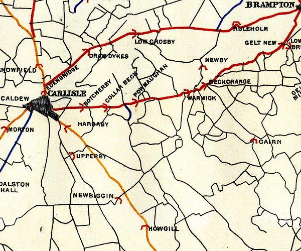 BEL9NY45.jpg  BEL9NY56.jpg red - disturnpiked 'main road' under section 13 of the Highways Act 1878 Road map of Cumberland showing County Bridges item:- Carlisle Library : Map 38 Images © Carlisle Library |
|||
|
|
||||
| evidence:- | old strip map:- CTC 1911 (Roads) |
|||
| source data:- | Page 88 of Cyclists' Touring Club British Road Book new series vol.6, edited by F
B Sandford, published by Thomas Nelson and Sons, London etc, 1911.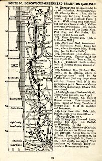 click to enlarge click to enlargeCTC288.jpg Strip road map, route 40, Borcovicus Greenhead Brampton Carlisle, part of Newcastle to Carlisle, scale roughly 5 miles to 1 inch. Together with an itinerary and gradient diagram. item:- JandMN : 491.88 Image © see bottom of page |
|||
|
|
||||
 Act of Parliament Act of Parliament |
||||
|
|
||||
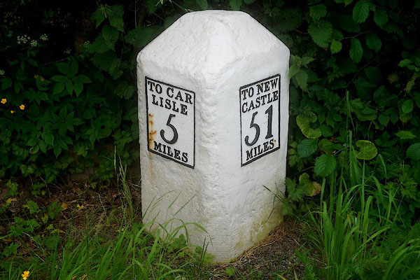
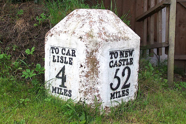
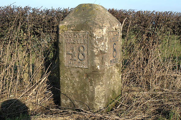
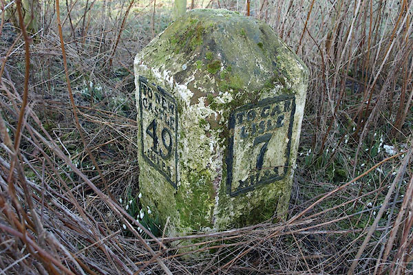
| places:- | Carlisle Stanwix, Carlisle Low Crosby, Stanwix Rural Brampton |
|||
|
|
||||
| places:- |
|
|||
|
||||
|
||||
|
||||
|
||||
|
||||
|
||||
|
||||
|
||||
|
||||
|
||||
Lakes Guides menu.