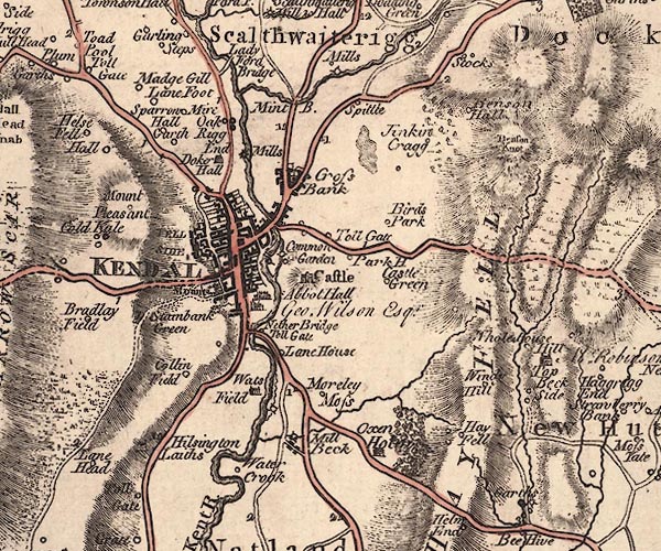
 Jefferys 1770 SD59SW

|

|
|
|
gazetteer links places may or may not be labelled on the map |
||

|
-- Abbot Hall Art Gallery -- "Abbot Hall / Geo. Wilson
Esqr." |
|
|
|
-- Beck Mills Farm -- "Mills" |
|
|
|
-- Benson Hall -- "Benson Hall" |
|
|
|
-- Benson Knott -- "Benson Knot" |
|
|
|
-- Birds Park Farm -- "Birds Park" |
|
|
|
-- Birds Park Reservoir |
|
|
|
-- Blind Beck (?) |
|
|
|
-- bridge, Kendal |
|
|
|
-- bridge, Kendal |
|
|
|
-- bridge, Kendal |
|
|
|
-- Castle Green -- "Castle Green" |
|
|
|
-- Castle Howe -- "Mount" |
|
|
|
-- Castle Meadows -- "Park House" |
|
|
|
-- Castle Mills |
|
|
|
-- Castlegreen Farm -- "Castle Green" |
|
|
|
-- Collin Field -- "Collin Field" |
|
|
|
-- Common Garden -- "Common Garden" |
|
|
|
-- Dockray Hall Mill -- "Mills" |
|
|
|
-- Dockray Hall -- "Doker Hall" |
|
|
|
-- Far Cross Bank -- "Cross Bank" |
|
|
|
-- Gill House -- "Beck Side" |
|
|
|
-- Hall House Farm -- "Whole House" |
|
|
|
-- Hallgarth -- "Hall Garth" |
|
|
|
-- Hay Fell -- "HAY FELL" |
|
|
|
-- Hayfellside -- "Hay Fell" |
|
|
|
-- Helsington Laithes -- "Hilsington Laiths" |
|
|
|
-- Helsington Turn Pike -- "Toll Gate" |
|
|
|
-- High Jenkincrag -- "Jinkin Cragg" |
|
|
|
-- Holy Trinity Church |
|
|
|
-- Jenkincrag -- "Jinkin Cragg" |
|
|
|
-- Kendal Castle -- "Castle" |
|
|
|
-- Kendal -- "KENDAL" |
|
|
|
-- Aikrigg End -- "Oak Rigg End" |
|
|
|
-- Kent, River -- "Kent R." -- "Kent R." --
"KENT RIVER" |
|
|
|
-- Ladyford Bridge -- "Lady Ford Bridge" |
|
|
|
-- Lane Foot -- "Lane Foot" |
|
|
|
-- Lane House -- "Lane House" |
|
|
|
-- Low Fellside -- "FELL SIDE" |
|
|
|
-- Low Mills |
|
|
|
-- Low Sparrowmire Farm -- "Sparrow Mire" |
|
|
|
-- Madgegill -- "Madge Gill" |
|
|
|
-- Middle Sparrowmire -- "Sparrow Mire" |
|
|
|
-- milestone, Kendal -- "1" |
|
|
|
-- milestone, Kendal -- "1" |
|
|
|
-- milestone, Kendal -- "1" |
|
|
|
-- milestone, Kendal -- "1" |
|
|
|
-- milestone, Scalthwaiterigg -- "2" |
|
|
|
-- Miller Bridge |
|
|
|
-- Mint Bridge -- "Mint B." |
|
|
|
-- Mint, River |
|
|
|
-- Mount Pleasant -- "Mount Pleasant" |
|
|
|
-- Murley Moss -- "Morley Moss" |
|
|
|
-- Natland Beck Mill |
|
|
|
-- Natland Beck |
|
|
|
-- Natland Mill Beck Farm -- "Mill Beck" |
|
|
|
-- Nether Bridge Turn Pike -- "Toll Gate" |
|
|
|
-- Nether Bridge -- "Nether Bridge" |
|
|
|
-- Oxenholme Farm -- "Oxen Holm" |
|
|
|
-- Kendal to Hawkshead |
|
|
|
-- Kendal to Kirkby Lonsdale-- Kendal to Kirkby Lonsdale |
|
|
|
-- Kendal to Newby Bridge |
|
|
|
-- Kendal to Sedbergh |
|
|
|
-- Kendal to Shap |
|
|
|
-- Kendal to Tebay |
|
|
|
-- Kendal to Windermere |
|
|
|
-- Lancaster to Kendal -- "from Lancaster" |
|
|
|
-- Milnthorpe to Kendal |
|
|
|
-- Brigsteer Road |
|
|
|
-- Burneside road |
|
|
|
-- Natland Road |
|
|
|
-- Mealbank Road (etc) |
|
|
|
-- Scalthwaiterigg Stocks -- "Stocks" |
|
|
|
-- Spital -- "Spittle" |
|
|
|
-- Stainbank Green -- "Stainbank Green" |
|
|
|
-- Stramongate Bridge |
|
|
|
-- toll gate, Kendal -- "Toll Gate" |
|
|
|
-- Watercrook -- "Water Crook" |
|
|
|
-- Wattsfield -- "Wats Field" |
|
|
|
-- Windy Hill Farm -- "Windy Hill" |
|
|
civil parishes The area roughly includes parts of parishes:- Strickland Ketel Skelsmergh Scalthwaiterigg Kendal New Hutton Helsington Natland |
||
|
|
||
|
|
Lakes Guides menu. | |