 Old Cumbria Gazetteer
 |
 |
|
| Helsington Laithes, Kendal | ||
| Helsington Laithes | ||
| civil parish:- | Kendal (formerly Westmorland) | |
| county:- | Cumbria | |
| locality type:- | buildings | |
| coordinates:- | SD50629070 | |
| 1Km square:- | SD5090 | |
| 10Km square:- | SD59 | |
|
|
||
| evidence:- | old map:- OS County Series (Wmd 38 12) placename:- Helsington Laithes |
|
| source data:- | Maps, County Series maps of Great Britain, scales 6 and 25
inches to 1 mile, published by the Ordnance Survey, Southampton,
Hampshire, from about 1863 to 1948. |
|
|
|
||
| evidence:- | old map:- Saxton 1579 placename:- Helston Lathe |
|
| source data:- | Map, hand coloured engraving, Westmorlandiae et Cumberlandiae Comitatus ie Westmorland
and Cumberland, scale about 5 miles to 1 inch, by Christopher Saxton, London, engraved
by Augustinus Ryther, 1576, published 1579-1645.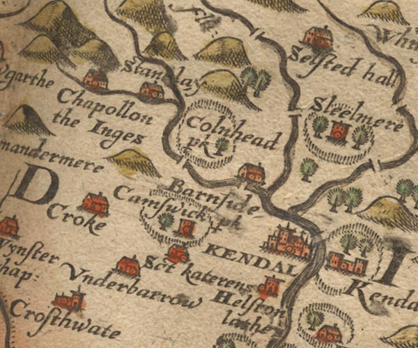 Sax9SD49.jpg Tower, symbol for a house, hall, tower, etc. "Helston lathe" item:- private collection : 2 Image © see bottom of page |
|
|
|
||
| evidence:- | old map:- Speed 1611 (Wmd) placename:- Helstonlathe |
|
| source data:- | Map, hand coloured engraving, The Countie Westmorland and
Kendale the Cheif Towne, scale about 2.5 miles to 1 inch, by
John Speed, 1610, published by George Humble, Popes Head Alley,
London, 1611-12.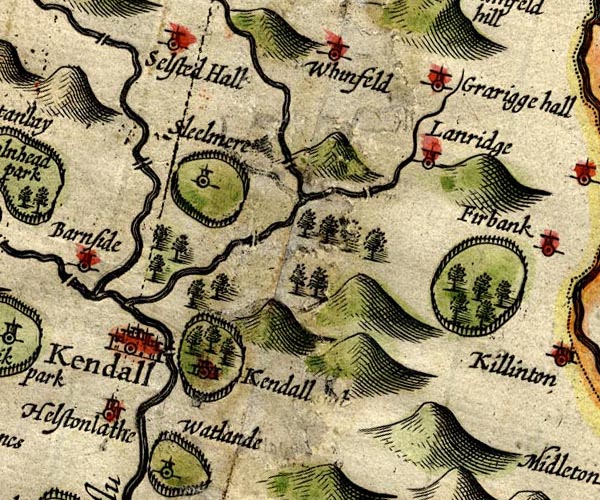 SP14SD59.jpg "Helstonlathe" circle, building and tower item:- Armitt Library : 2008.14.5 Image © see bottom of page |
|
|
|
||
| evidence:- | old map:- Jansson 1646 placename:- Helstonlathe |
|
| source data:- | Map, hand coloured engraving, Cumbria and Westmoria, ie
Cumberland and Westmorland, scale about 3.5 miles to 1 inch, by
John Jansson, Amsterdam, Netherlands, 1646.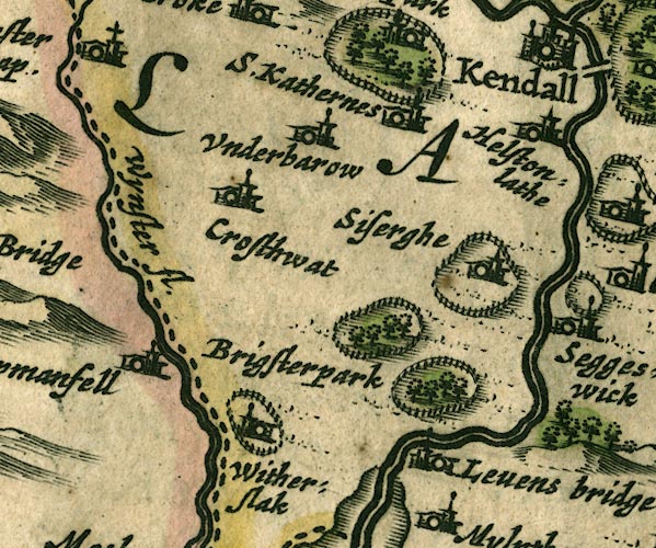 JAN3SD48.jpg "Helstonlathe" Buildings and tower. item:- JandMN : 88 Image © see bottom of page |
|
|
|
||
| evidence:- | hearth tax returns:- Hearth Tax 1675 placename:- Helston Leathes |
|
| source data:- | Records, hearth tax survey returns, Westmorland, 1674/75. "Helston Leathes" in "Helsington" |
|
|
|
||
| evidence:- | old map:- Seller 1694 (Wmd) placename:- Helstonlath |
|
| source data:- | Map, hand coloured engraving, Westmorland, scale about 8 miles
to 1 inch, by John Seller, 1694. click to enlarge click to enlargeSEL7.jpg "Helstonlath" circle, italic lowercase text; settlement or house item:- Dove Cottage : 2007.38.87 Image © see bottom of page |
|
|
|
||
| evidence:- | probably old map:- Morden 1695 (Wmd) placename:- Helston Lea |
|
| source data:- | Map, hand coloured engraving, Westmorland, scale about 2.5 miles to 1 inch, by Robert
Morden, published by Abel Swale, the Unicorn, St Paul's Churchyard, Awnsham, and John
Churchill, the Black Swan, Paternoster Row, London, 1695.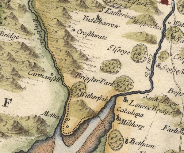 MD10SD48.jpg "Helston lea" Circle. item:- JandMN : 24 Image © see bottom of page |
|
|
|
||
| evidence:- | old map:- Bowen and Kitchin 1760 placename:- Helstonlathe |
|
| source data:- | Map, hand coloured engraving, A New Map of the Counties of
Cumberland and Westmoreland Divided into their Respective Wards,
scale about 4 miles to 1 inch, by Emanuel Bowen and Thomas
Kitchin et al, published by T Bowles, Robert Sayer, and John
Bowles, London, 1760.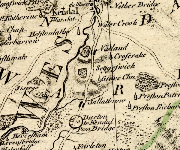 BO18SD48.jpg "Helstonlathe" circle, tower item:- Armitt Library : 2008.14.10 Image © see bottom of page |
|
|
|
||
| evidence:- | old map:- Jefferys 1770 (Wmd) placename:- Hilsington Laiths |
|
| source data:- | Map, 4 sheets, The County of Westmoreland, scale 1 inch to 1
mile, surveyed 1768, and engraved and published by Thomas
Jefferys, London, 1770. J5SD59SW.jpg "Hilsington Laiths" house item:- National Library of Scotland : EME.s.47 Image © National Library of Scotland |
|
|
|
||
| evidence:- | probably old map:- Ford 1839 map placename:- Helsington placename:- Helsington Laithes |
|
| source data:- | Map, uncoloured engraving, Map of the Lake District of
Cumberland, Westmoreland and Lancashire, scale about 3.5 miles
to 1 inch, published by Charles Thurnam, Carlisle, and by R
Groombridge, 5 Paternoster Row, London, 3rd edn 1843. FD02SD48.jpg "Helsington" "Helsington Laithes" item:- JandMN : 100.1 Image © see bottom of page |
|
|
|
||
| evidence:- | database:- Listed Buildings 2010 placename:- Helsington Laithes Farm |
|
| source data:- | courtesy of English Heritage "HELSINGTON LAITHES FARMHOUSE / / A6 / KENDAL / SOUTH LAKELAND / CUMBRIA / II[star] / 75342 / SD5062290700" |
|
|
|
||
| evidence:- | database:- Listed Buildings 2010 |
|
| source data:- | courtesy of English Heritage "BRIDGE CARRYING FARM ROAD TO NORTH EAST OF HELSINGTON LAITHES FARMHOUSE / / A6 / KENDAL / SOUTH LAKELAND / CUMBRIA / II / 437730 / SD5069390733" |
|
| source data:- | courtesy of English Heritage "Bridge, probably C16/C17. Large, roughly-dressed, stone blocks. Single semicircular arch spanning c5 ft. Roadway c12 ft wide with splayed parapets c3 ft high." |
|
|
|
||
| evidence:- | database:- Listed Buildings 2010 |
|
| source data:- | courtesy of English Heritage "BRIDGE CARRYING DRIVE TO NORTH EAST OF HELSINGTON LAITHES FARMHOUSE / / A6 / KENDAL / SOUTH LAKELAND / CUMBRIA / II[star] / 75343 / SD5067190736" |
|
| source data:- | courtesy of English Heritage "Bridge, probably C18. Coursed, squared rubble with single elliptical arch spanning c5 ft. Roadway c10 ft wide with parapets c3 ft high. Included for group value." |
|
|
|
||
| notes:- |
hall |
|
| Perriam, D R &Robinson, J: 1998: Medieval Fortified Buildings of Cumbria: CWAAS::
ISBN 1 873124 23 6; plan and illustration |
||
|
|
||
| hearsay:- |
There is a chapel in the hall, and a small room attached referred to as the surplice
room, and nearby a stair to a tiny room in the rafters. |
|
| A maid had this room was allocated this room as her bedroom, and when the mistress
of the house went up to find her next morning, she had gone and was never seen again.
Since then, in time of trouble, the maid, a lady in grey, is seen to walk on the landing
below. |
||
| Palmer 1945 |
||
|
|
||
| hearsay:- |
Plasterwork in the drawing room has an inscription:- |
|
| "[B / I A / 1538]" |
||
| Palmer 1945 |
||
|
|
||
 Lakes Guides menu.