Old Cumbria Gazetteer
 |
 |
|
|||||||||||||||||||||||||||
| included in:- |
 road, Kendal to Cockermouth road, Kendal to Cockermouth |
||||||||||||||||||||||||||||
| road, Kendal to Windermere | |||||||||||||||||||||||||||||
| Kendal to Windermere | |||||||||||||||||||||||||||||
| Windermere to Kendal | |||||||||||||||||||||||||||||
| A591 | |||||||||||||||||||||||||||||
| civil parish:- | Kendal (formerly Westmorland) | ||||||||||||||||||||||||||||
| civil parish:- | Strickland Ketel (formerly Westmorland) | ||||||||||||||||||||||||||||
| civil parish:- | Nether Staveley (formerly Westmorland) | ||||||||||||||||||||||||||||
| civil parish:- | Over Staveley (formerly Westmorland) | ||||||||||||||||||||||||||||
| civil parish:- | Hugill (formerly Westmorland) | ||||||||||||||||||||||||||||
| civil parish:- | Windermere (formerly Westmorland) | ||||||||||||||||||||||||||||
| county:- | Cumbria | ||||||||||||||||||||||||||||
| locality type:- | road route | ||||||||||||||||||||||||||||
| 10Km square:- | SD59 | ||||||||||||||||||||||||||||
| 10Km square:- | SD49 | ||||||||||||||||||||||||||||
|
|
|||||||||||||||||||||||||||||
| evidence:- | old map:- Speed 1611 placename:- |
||||||||||||||||||||||||||||
| source data:- | Map, hand coloured engraving, The Countie Westmorland and
Kendale the Cheif Towne, scale about 2.5 miles to 1 inch, by
John Speed, 1610, published by George Humble, Popes Head Alley,
London, 1611-12.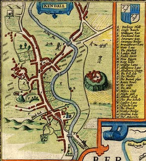 click to enlarge click to enlargeSP14Mk.jpg road N from Stricklandgate item:- Armitt Library : 2008.14.5 Image © see bottom of page |
||||||||||||||||||||||||||||
|
|
|||||||||||||||||||||||||||||
| evidence:- | old map:- Ogilby 1675 |
||||||||||||||||||||||||||||
| source data:- | Road strip map, hand coloured engraving, the Road from Kendal to
Cockermouth, and the Road from Egremond to Carlisle, scale about
1 inch to 1 mile, by John Ogilby, London, 1675.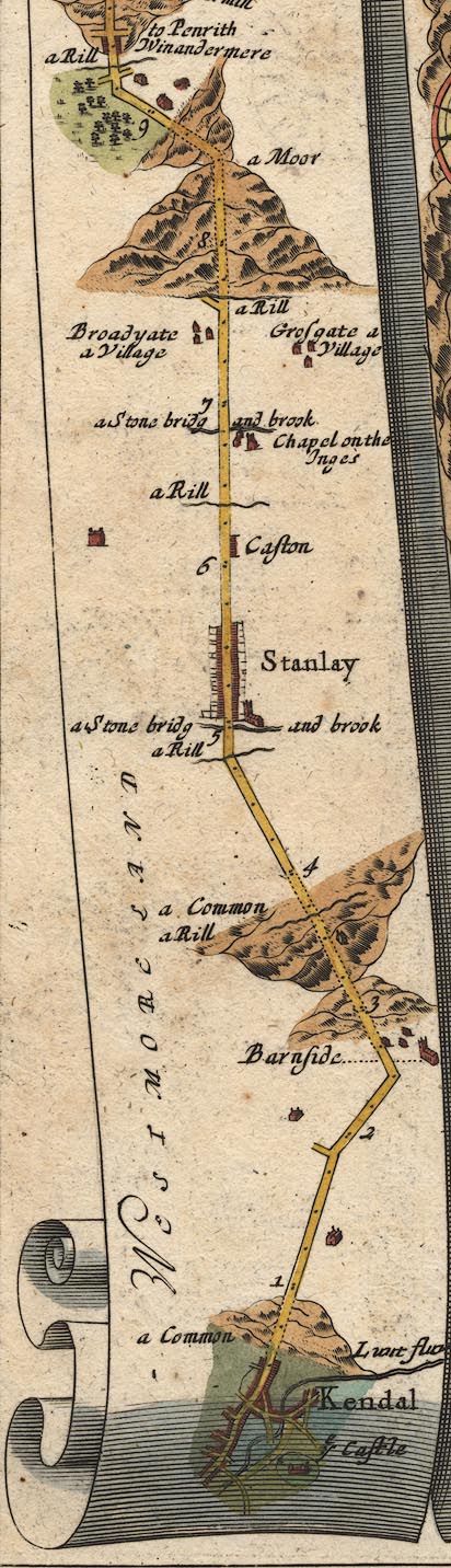 OG96KtoW.jpg item:- JandMN : 22 Image © see bottom of page |
||||||||||||||||||||||||||||
|
|
|||||||||||||||||||||||||||||
| evidence:- | old map:- Bowen 1720 (plate 260) |
||||||||||||||||||||||||||||
| source data:- | Road strip map, uncoloured engraving, pl.260, The Road from
Kendal to Cockermouth, scale about 2 miles to 1 inch, with
sections in Westmorland and Cumberland, published by Emanuel
Bowen, St Katherines, London, 1720.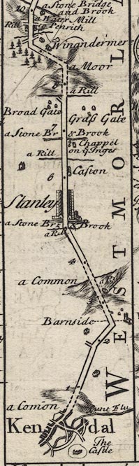 B260KtoW.jpg The Road from Kendal to Cockermouth - from Kendal on past Keswick, Cumberland. Places labelled are:- Kendal, a Com~on, The Castle, Lunt Flu / 1 ... 2 / Barnside on right / 3 ... 5 / Stanley / 6, Caston / Chappel on ye Inges on right / 7 / Grass Gate on right?, Broad Gate on left? / 8 / Winandermere / ... item:- private collection : 1.260 Image © see bottom of page |
||||||||||||||||||||||||||||
|
|
|||||||||||||||||||||||||||||
| evidence:- | old map:- Bowen 1720 (plate 259) |
||||||||||||||||||||||||||||
| source data:- | Road book, Britannia Depicta Or Ogilby Improv'd, including road
strip maps with sections in Westmorland and Cumberland, scale
about 2 miles to 1 inch, derived from maps by Ogilby, 1675, also
a county map of Westmorland, scale about 8 miles to 1 inch, and
of Cumberland, scale about 16.5 miles to 1 inch, each with text,
by John Owen, published by Emanuel Bowen, London, 1720;
published 1720-64. Plate 259 has the title cartouche for:- "The Roads from KENDAL to COCKERMOUTH, &c. Containing 32 Comp. and 43'7 measd. Miles &c." and a table of distances, computed and measured miles in miles'furlongs, which includes, from Kendal:- "Stanley 4 / 5'3" "..." |
||||||||||||||||||||||||||||
|
|
|||||||||||||||||||||||||||||
| evidence:- | old map:- Badeslade 1742 placename:- |
||||||||||||||||||||||||||||
| source data:- | Map, uncoloured engraving, A Map of Westmorland North from
London, scale about 10 miles to 1 inch, with descriptive text,
by Thomas Badeslade, London, engraved and published by William
Henry Toms, Union Court, Holborn, London, 1742. click to enlarge click to enlargeBD12.jpg "" double line item:- Dove Cottage : 2007.38.62 Image © see bottom of page |
||||||||||||||||||||||||||||
|
|
|||||||||||||||||||||||||||||
| evidence:- | old map:- Simpson 1746 map (Wmd) |
||||||||||||||||||||||||||||
| source data:- | Map, uncoloured engraving, Westmorland, scale about 8 miles to 1
inch, printed by R Walker, Fleet Lane, London, 1746.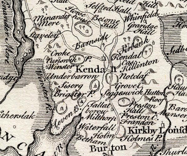 SMP2SDP.jpg Double line. item:- Dove Cottage : 2007.38.59 Image © see bottom of page |
||||||||||||||||||||||||||||
|
|
|||||||||||||||||||||||||||||
| evidence:- | old map:- Bowen and Kitchin 1760 |
||||||||||||||||||||||||||||
| source data:- | Map, hand coloured engraving, A New Map of the Counties of
Cumberland and Westmoreland Divided into their Respective Wards,
scale about 4 miles to 1 inch, by Emanuel Bowen and Thomas
Kitchin et al, published by T Bowles, Robert Sayer, and John
Bowles, London, 1760.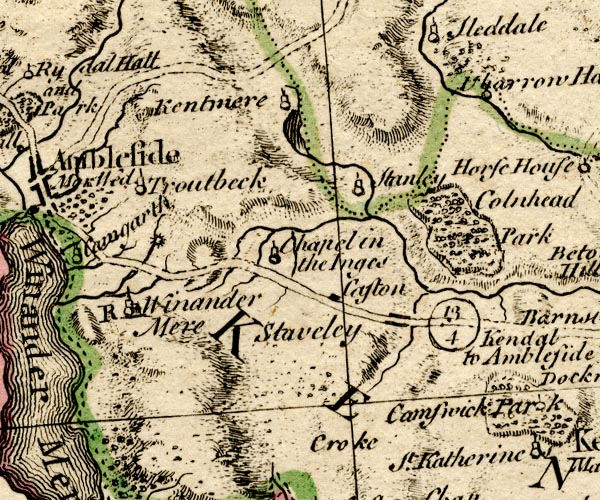 BO18SD39.jpg "Kendal to Ambleside 13 4" double line, solid and dotted 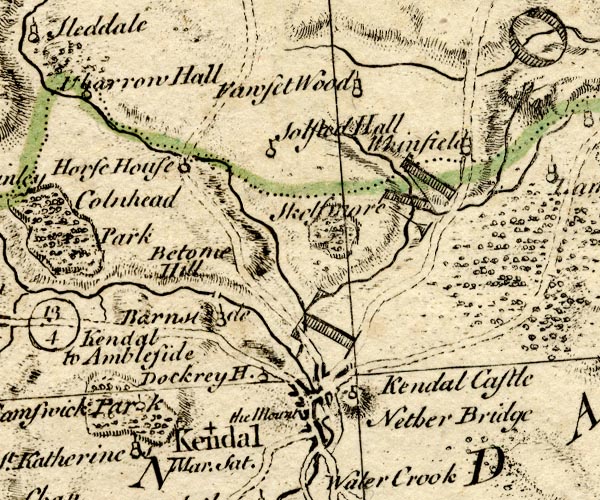 BO18SD49.jpg double line, solid item:- Armitt Library : 2008.14.10 Image © see bottom of page |
||||||||||||||||||||||||||||
|
|
|||||||||||||||||||||||||||||
| evidence:- | old map:- Kitchin 1767 (plate 84) |
||||||||||||||||||||||||||||
| source data:- | Road strip map, uncoloured engraving, The Road from Kendal to
Cockermouth, and The Road from Egremont to Carlisle, in
Kitchin's Post Chaise Companion, by Thomas Kitchin, published by
Robert Sayer, 53 Fleet Street, John Bowles, Cornhill, and
Carington Bowles, St Paul's Church Yard, London, 1767.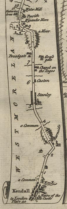 K084KtoW.jpg item:- Hampshire Museums : FA1999.138.84 Image © see bottom of page |
||||||||||||||||||||||||||||
|
|
|||||||||||||||||||||||||||||
| evidence:- | old map:- Jefferys 1770 (Wmd) |
||||||||||||||||||||||||||||
| source data:- | Map, 4 sheets, The County of Westmoreland, scale 1 inch to 1
mile, surveyed 1768, and engraved and published by Thomas
Jefferys, London, 1770.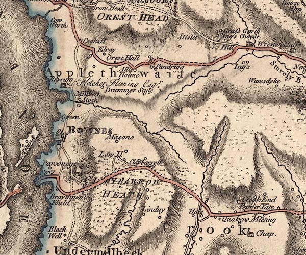 J5SD49NW.jpg  J5SD49NE.jpg  J5SD59SW.jpg double line; road, bold, main road, with mile numbers item:- National Library of Scotland : EME.s.47 Images © National Library of Scotland |
||||||||||||||||||||||||||||
|
|
|||||||||||||||||||||||||||||
| evidence:- | old map:- Cary 1789 (edn 1805) |
||||||||||||||||||||||||||||
| source data:- | Map, uncoloured engraving, Westmoreland, scale about 2.5 miles
to 1 inch, by John Cary, London, 1789; edition 1805. CY24SD49.jpg double line, bold light, numbered miles; main road item:- JandMN : 129 Image © see bottom of page |
||||||||||||||||||||||||||||
|
|
|||||||||||||||||||||||||||||
| evidence:- | road map:- Cary 1790 (Wmd/edn 1792) |
||||||||||||||||||||||||||||
| source data:- | Road map, hand coloured engraving, Westmoreland, scale about
11.5 miles to 1 inch, by John Cary, 181 Strand, London, 1790,
edn 1792. click to enlarge click to enlargeCY16.jpg no Windermere shown double line, with road distances from Kendal item:- JandMN : 44 Image © see bottom of page |
||||||||||||||||||||||||||||
|
|
|||||||||||||||||||||||||||||
| evidence:- | road book:- Cary 1798 (2nd edn 1802) |
||||||||||||||||||||||||||||
| source data:- | Road book, itineraries, Cary's New Itinerary, by John Cary, 181
Strand, London, 2nd edn 1802. goto source click to enlarge click to enlargeC38267.jpg page 267-268 "At Kendal ... on l. [T.Rs.] to Milthorpe, Ulverston, Winander Mere, and Ambleside." goto source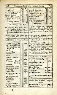 click to enlarge click to enlargeC38317.jpg page 317-318 "LONDON to Cockermouth and Workington" part of goto source click to enlargeC38317.jpg page 317-318 "Near 2 Miles beyond Kendal, on l. a T.R. to Winander Mere" item:- JandMN : 228.1 Image © see bottom of page |
||||||||||||||||||||||||||||
|
|
|||||||||||||||||||||||||||||
| evidence:- | descriptive text:- Baker 1802 |
||||||||||||||||||||||||||||
| source data:- | Perspective road map with sections in Lancashire, Westmorland,
and Cumberland, by J Baker, London 1802. pp.25-26:- "... After passing a short way from Kendal, the views of the country become extremely interesting. Near the eye some of it is waste, partly spotted, and patched, with short wood, and it is partially cultivated, whilst massive protuberances or fractured partitions of the native stratum of grey-coloured stone bursts to appearance through the soil in every direction. At some part of the way, the distance is disagreeably w[i]ld, at others placid, romantic, and picturesque. Sometimes there appears over the whole the vast Stavely and Coitmoor fells towering among the clouds in indescribable sublimity. ..." |
||||||||||||||||||||||||||||
|
|
|||||||||||||||||||||||||||||
| evidence:- | old map:- Cooke 1802 |
||||||||||||||||||||||||||||
| source data:- | Map, Westmoreland ie Westmorland, scale about 12 miles to 1
inch, by George Cooke, 1802, published by Sherwood, Jones and
Co, Paternoster Road, London, 1824. click to enlarge click to enlargeGRA1Wd.jpg though no Windermere, double line, light dark solid; road item:- Hampshire Museums : FA2000.62.4 Image © see bottom of page |
||||||||||||||||||||||||||||
|
|
|||||||||||||||||||||||||||||
| evidence:- | old map:- Laurie and Whittle 1806 |
||||||||||||||||||||||||||||
| source data:- | Road map, Completion of the Roads to the Lakes, scale about 10
miles to 1 inch, by Nathaniel Coltman? 1806, published by Robert
H Laurie, 53 Fleet Street, London, 1834. click to enlarge click to enlargeLw18.jpg bold line; 'Principal Travelling Roads' item:- private collection : 18.18 Image © see bottom of page |
||||||||||||||||||||||||||||
|
|
|||||||||||||||||||||||||||||
| evidence:- | old map:- Wallis 1810 (Wmd) |
||||||||||||||||||||||||||||
| source data:- | Road map, Westmoreland, scale about 19 miles to 1 inch, by James
Wallis, 77 Berwick Street, Soho, 1810, published by W Lewis,
Finch Lane, London, 1835? click to enlarge click to enlargeWAL5.jpg double line, light bold; 'Turnpike Road' item:- JandMN : 63 Image © see bottom of page |
||||||||||||||||||||||||||||
|
|
|||||||||||||||||||||||||||||
| evidence:- | old map:- Hall 1820 (Wmd) |
||||||||||||||||||||||||||||
| source data:- | Map, hand coloured engraving, Westmoreland ie Westmorland, scale
about 14.5 miles to 1 inch, by Sidney Hall, London, 1820,
published by Samuel Leigh, 18 Strand, London, 1820-31. click to enlarge click to enlargeHA18.jpg single line, solid; minor road; to Applethwaite; Kendal, Stavely, Weston Hall - Reston Hall, Applethwaite item:- Armitt Library : 2008.14.58 Image © see bottom of page |
||||||||||||||||||||||||||||
|
|
|||||||||||||||||||||||||||||
| evidence:- | descriptive text:- Ford 1839 (3rd edn 1843) |
||||||||||||||||||||||||||||
| source data:- | Guide book, A Description of Scenery in the Lake District, by
Rev William Ford, published by Charles Thurnam, Carlisle, by W
Edwards, 12 Ave Maria Lane, Charles Tilt, Fleet Street, William
Smith, 113 Fleet Street, London, by Currie and Bowman,
Newcastle, by Bancks and Co, Manchester, by Oliver and Boyd,
Edinburgh, and by Sinclair, Dumfries, 1839. goto source Page 22:- "..." "The road leaves Kendal by a steep ascent, having the workhouse and prison on either hand. The views northward, in the direction of Shap and Orton, are pretty, not unlike the vale of Derbyshire: southward, there is an opening through the marble jaws of Underbarrow, showing the varied" goto sourcePage 23:- "but pleasing localities of the country. Five miles from Kendal is Stavely, ..." goto sourcePage 160:- "..." "VII. KENDAL TO AMBLESIDE.- 13½M."
|
||||||||||||||||||||||||||||
|
|
|||||||||||||||||||||||||||||
| evidence:- | old map:- Ford 1839 map |
||||||||||||||||||||||||||||
| source data:- | Map, uncoloured engraving, Map of the Lake District of
Cumberland, Westmoreland and Lancashire, scale about 3.5 miles
to 1 inch, published by Charles Thurnam, Carlisle, and by R
Groombridge, 5 Paternoster Row, London, 3rd edn 1843.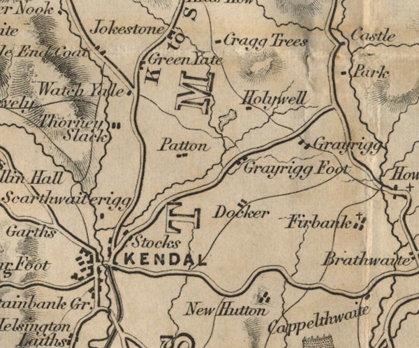 FD02SD59.jpg 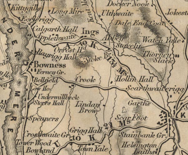 FD02SD49.jpg "A to K 13½Ms." Distance Kendal to Ambleside; the old road ignores Windermere, which didn't much exist. item:- JandMN : 100.1 Image © see bottom of page |
||||||||||||||||||||||||||||
|
|
|||||||||||||||||||||||||||||
| evidence:- | old map:- Garnett 1850s-60s H |
||||||||||||||||||||||||||||
| source data:- | Map of the English Lakes, in Cumberland, Westmorland and
Lancashire, scale about 3.5 miles to 1 inch, published by John
Garnett, Windermere, Westmorland, 1850s-60s.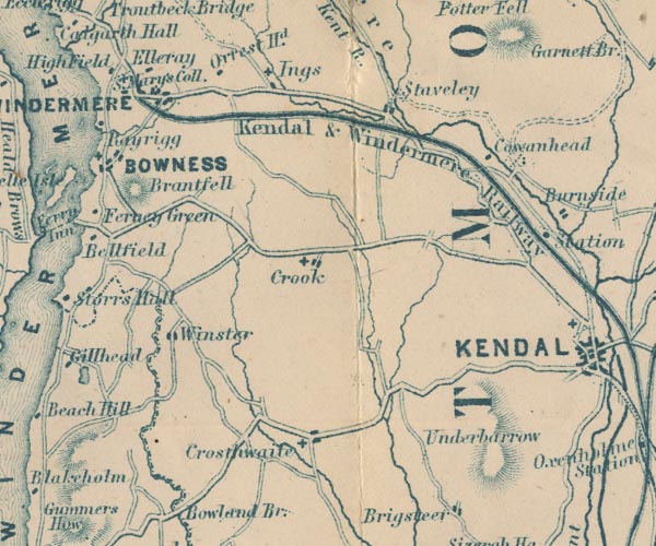 GAR2SD49.jpg  GAR2SD59.jpg item:- JandMN : 82.1 Image © see bottom of page |
||||||||||||||||||||||||||||
|
|
|||||||||||||||||||||||||||||
| evidence:- | old text:- Martineau 1855 |
||||||||||||||||||||||||||||
| source data:- | Guide book, A Complete Guide to the English Lakes, by Harriet
Martineau, published by John Garnett, Windermere, Westmorland,
and by Whittaker and Co, London, 1855; published 1855-76. goto source Page 5:- "... When the traveller foot or horseback sees certain reaches of Lake Windermere from Orrest Head, lying deep down below him, he knows he is coming near the end of the railway, ... The old coach road over Orrest Head and the railway meet at the new village of Windermere, whence the road to Bowness descends, ..." |
||||||||||||||||||||||||||||
|
|
|||||||||||||||||||||||||||||
| evidence:- | old map:- Prior 1874 map 1 |
||||||||||||||||||||||||||||
| source data:- | Map, uncoloured engraving or lithograph? Winander Mere, scale
about 2.5 miles to 1 inch, published by John Garnett,
Windermere, Westmorland, 1874. click to enlarge click to enlargePI03M1.jpg "To Kendal" double line; road item:- private collection : 133.1 Image © see bottom of page |
||||||||||||||||||||||||||||
|
|
|||||||||||||||||||||||||||||
| evidence:- | gradient diagram:- Gall and Inglis 1890s-1900s (Roads) |
||||||||||||||||||||||||||||
| source data:- | Contour Road Book of England, Northern Division, by Harry R G Inglis, published by
Gall and Inglis, 25 Paternoster Square, London and Edinburgh, 1898.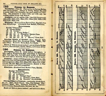 click to enlarge click to enlargeIG5185.jpg Itinerary, with gradient diagram, route 185, Kendal to Barrow, and route 187, Kendal to Keswick, Westmorland and Lancashire, 1898. item:- JandMN : 763.18 Image © see bottom of page |
||||||||||||||||||||||||||||
|
|
|||||||||||||||||||||||||||||
| evidence:- | old strip map:- CTC 1911 (Roads) |
||||||||||||||||||||||||||||
| source data:- | Page 57 of Cyclists' Touring Club British Road Book new series vol.6, edited by F
B Sandford, published by Thomas Nelson and Sons, London etc, 1911.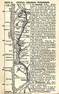 click to enlarge click to enlargeCTC257.jpg Strip road map, route 21, Keswick Ambleside Windermere, and Kendal, part of Silloth to Kendal, scale roughly 5 miles to 1 inch. Together with an itinerary and gradient diagram. item:- JandMN : 491.57 Image © see bottom of page |
||||||||||||||||||||||||||||
|
|
|||||||||||||||||||||||||||||
| evidence:- | old map:- Burrow 1920s |
||||||||||||||||||||||||||||
| source data:- | Road book, On the Road, Dunlop Pictorial Road Plans, volume V,
strip maps with parts in Westmorland, Cumberland etc, irregular
scale about 1.5 miles to 1 inch, by E J Burrow and Co,
Cheltenham, Gloucestershire, 1920s. EJB3KtoW.jpg item:- private collection : 17 Image © see bottom of page |
||||||||||||||||||||||||||||
|
|
|||||||||||||||||||||||||||||
| evidence:- | old text:- Burrow 1920s placename:- |
||||||||||||||||||||||||||||
| source data:- | Road book, strip maps with parts in Westmorland, Cumberland etc,
irregular scales about 1.5 miles to 1 inch, by E J Burrow and
Co, Cheltenham, Gloucestershire, 1920s. "... The western route, on leaving Kendal, heads straight for Windermere, climbing up a steep hill to an old toll-gate, passing through Staveley and then descending to Windermere town, which has grown up as a modern holiday centre on the very shore of the beautiful lake of the same name, the largest of the group. ..." |
||||||||||||||||||||||||||||
|
|
|||||||||||||||||||||||||||||
 Act of Parliament Act of Parliament |
|||||||||||||||||||||||||||||
|
|
|||||||||||||||||||||||||||||
| evidence:- | old strip map:- Rumney 1899 |
||||||||||||||||||||||||||||
| source data:- | Road map, strip map, gradient diagram, and itinerary for Route I, Kendal to Keswick,
Westmorland and Cumberland, scale about 2 miles to 1 inch, by A W Rumney, published
by George Philip and Son, 32 Fleet Street, London, and Liverpool, 1899.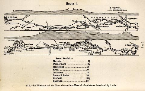 click to enlarge click to enlargeRUM103.jpg On p.14 of the Cyclist's Guide to the English Lake District, by A W Rumney. printed at top:- "Route I." item:- JandMN : 147.4 Image © see bottom of page |
||||||||||||||||||||||||||||
|
|
|||||||||||||||||||||||||||||
| hearsay:- |
A survey made for the promoters of the Kendal and Windermere branch railway gave figures
for travellers from Kendal to Bowness or Ambleside, November 1843 to November 1844
- 5934 on horse or by post chaise; 3375 in private carriages; 3755 by the Whitehaven
Mail or Mazeppa stage coaches. This does include carts. |
||||||||||||||||||||||||||||
|
|
|||||||||||||||||||||||||||||
| places:- | Kendal Staveley, Over Staveley Windermere |
||||||||||||||||||||||||||||
|
|
|||||||||||||||||||||||||||||
| places:- |
|
||||||||||||||||||||||||||||
|
|||||||||||||||||||||||||||||
|
|||||||||||||||||||||||||||||
|
|||||||||||||||||||||||||||||
|
|||||||||||||||||||||||||||||
|
|||||||||||||||||||||||||||||
|
|||||||||||||||||||||||||||||
|
|||||||||||||||||||||||||||||
|
|||||||||||||||||||||||||||||
|
|||||||||||||||||||||||||||||
Lakes Guides menu.