 Old Cumbria Gazetteer
 |
 |
|
| toll house, Plumgarths | ||
| gone | ||
| Plumgarths Toll Gate | ||
| site name:- | Ambleside Turnpike Road | |
| site name:- | road, Kendal to Windermere | |
| locality:- | Plumgarths | |
| civil parish:- | Strickland Ketel (formerly Westmorland) | |
| county:- | Cumbria | |
| locality type:- | toll gate (site) | |
| locality type:- | toll house (ex) | |
| locality type:- | buildings | |
| coordinates:- | SD49769460 (estimate) | |
| 1Km square:- | SD4994 | |
| 10Km square:- | SD49 | |
|
|
||
| evidence:- | old map:- OS County Series (Wmd 38 3) placename:- Plumgarths TP |
|
| source data:- | Maps, County Series maps of Great Britain, scales 6 and 25
inches to 1 mile, published by the Ordnance Survey, Southampton,
Hampshire, from about 1863 to 1948. "Plumgarths T.P." at a fork; gates across both roads, and a building |
|
|
|
||
| evidence:- | old map:- Jefferys 1770 (Wmd) |
|
| source data:- | Map, 4 sheets, The County of Westmoreland, scale 1 inch to 1
mile, surveyed 1768, and engraved and published by Thomas
Jefferys, London, 1770.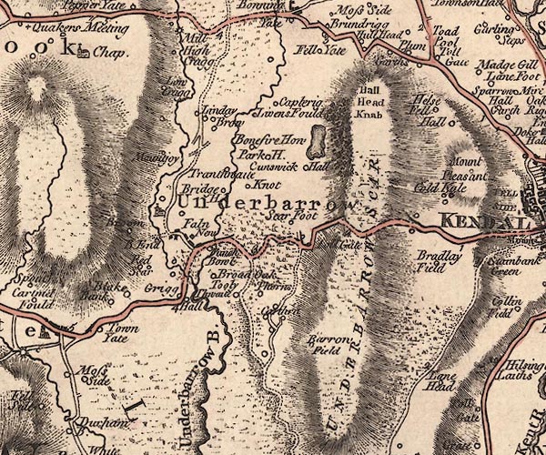 J5SD49SE.jpg "Toll Gate" circle, labelled in italic lowercase text; settlement, farm, house, or hamlet? item:- National Library of Scotland : EME.s.47 Image © National Library of Scotland |
|
|
|
||
| evidence:- | notice:- placename:- Plumgarths Toll Gate |
|
| source data:- | "AMBLESIDE Turnpike Road. / Tolls to Let. / ... the Tolls arising at the Toll Gates
upon the Ambleside Turnpike Road, called and known by the names of PLUMGARTHS, STAVELEY,
BONNINGATE CHAIN, WATER HEAD, and GRASMERE TOLL GATES, will be Let by Auction, ...
at the House of Mr.JOSEPH BARROW, the Commercial Inn, in Kendal ... which Tolls produced
the last year as follows, that is to say,- / Plumgarths and Staveley Gate, with Bonningate
Chain ... L331 / Waterhead Gate and Grasmere Gate ... L680 / Above the expenses of
collecting them , ... / WILLIAM PETTY, Clerk to the Trustees ... Kendal, August 24th,
1854. / T. ATKINSON, PRINTER, KENDAL." |
|
|
|
||
| evidence:- | old text:- Burrow 1920s |
|
| source data:- | Road book, strip maps with parts in Westmorland, Cumberland etc,
irregular scales about 1.5 miles to 1 inch, by E J Burrow and
Co, Cheltenham, Gloucestershire, 1920s. "[the road] ... on leaving Kendal, heads straight for Windermere, climbing up a steep hill to an old toll-gate, passing through Staveley ..." |
|
|
|
||
| hearsay:- |
12000 passenger vehicles paid tolls, year 1844-45. |
|
|
|
||
| hearsay:- |
About 1961, the Gazette reported (with picture) the demolition of Old Toll-Bar Cottage
here, built around 1830. This was to enable road widening. |
|
|
|
||
 Lakes Guides menu.