 Old Cumbria Gazetteer
 |
 |
|
| Benson Knott, Scalthwaiterigg | ||
| Benson Knott | ||
| civil parish:- | Scalthwaiterigg (formerly Westmorland) | |
| county:- | Cumbria | |
| locality type:- | hill | |
| coordinates:- | SD54769415 (etc) | |
| 1Km square:- | SD5494 | |
| 10Km square:- | SD59 | |
| altitude:- | 1040 feet | |
| altitude:- | 317m | |
|
|
||
| evidence:- | old map:- OS County Series (Wmd 39 1) placename:- Benson Knott |
|
| source data:- | Maps, County Series maps of Great Britain, scales 6 and 25
inches to 1 mile, published by the Ordnance Survey, Southampton,
Hampshire, from about 1863 to 1948. |
|
|
|
||
| evidence:- | old map:- Jefferys 1770 (Wmd) placename:- Benson Knot |
|
| source data:- | Map, 4 sheets, The County of Westmoreland, scale 1 inch to 1
mile, surveyed 1768, and engraved and published by Thomas
Jefferys, London, 1770. J5SD59SW.jpg "Benson Knot" hill hachuring; hill or mountain item:- National Library of Scotland : EME.s.47 Image © National Library of Scotland |
|
|
|
||
| evidence:- | descriptive text:- West 1778 (11th edn 1821) placename:- Benson Knot |
|
| source data:- | Guide book, A Guide to the Lakes, by Thomas West, published by
William Pennington, Kendal, Cumbria once Westmorland, and in
London, 1778 to 1821. goto source goto sourcePage 190:- "A TABLE OF THE Height of Mountains and Lakes SEEN IN THIS TOUR, ... TAKEN FROM THE LEVEL OF THE SEA. ... by Mr. John Dalton." "Benson-knot, near Kendal ... 366 [yards]" |
|
|
|
||
| evidence:- | old map:- Garnett 1850s-60s H placename:- Benson Knott |
|
| source data:- | Map of the English Lakes, in Cumberland, Westmorland and
Lancashire, scale about 3.5 miles to 1 inch, published by John
Garnett, Windermere, Westmorland, 1850s-60s.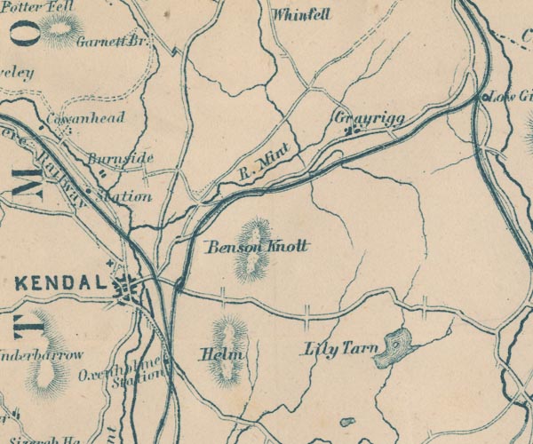 GAR2SD59.jpg "Benson Knott" hill hachuring item:- JandMN : 82.1 Image © see bottom of page |
|
|
|
||
Lakes Guides menu.