 Old Cumbria Gazetteer
 |
 |
|
|
| included in:- |
 road, Windermere to Coniston partly road, Hawkshead to Newby Bridge partly road, Windermere to Coniston partly road, Hawkshead to Newby Bridge partly
|
||
| road, Kendal to Hawkshead | |||
| Kendal to Hawkshead | |||
| Hawkshead to Kendal | |||
| A5284 | |||
| A5285 | |||
| civil parish:- | Kendal (formerly Westmorland) | ||
| civil parish:- | Strickland Ketel (formerly Westmorland) | ||
| civil parish:- | Crook (formerly Westmorland) | ||
| civil parish:- | Windermere (formerly Westmorland) | ||
| civil parish:- | Claife (formerly Lancashire) | ||
| civil parish:- | Hawkshead (formerly Lancashire) | ||
| county:- | Cumbria | ||
| locality type:- | road route | ||
| 10Km square:- | SD59 | ||
| 10Km square:- | SD49 | ||
| 10Km square:- | SD39 | ||
|
|
|||
| evidence:- | old map:- Jefferys 1770 (Wmd) |
||
| source data:- | Map, 4 sheets, The County of Westmoreland, scale 1 inch to 1
mile, surveyed 1768, and engraved and published by Thomas
Jefferys, London, 1770.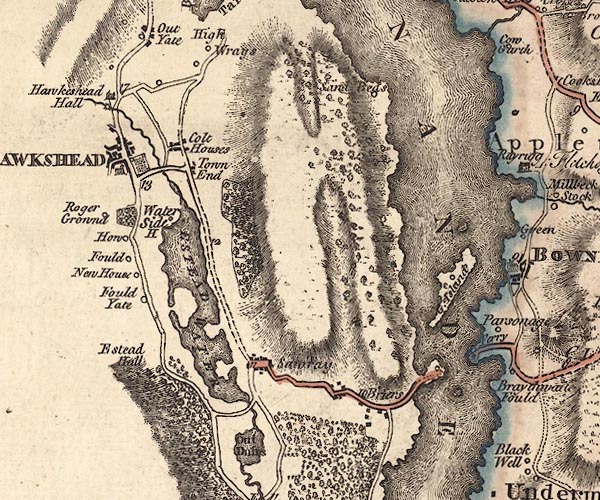 J5SD39NE.jpg 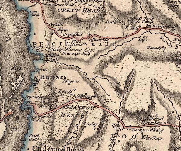 J5SD49NW.jpg 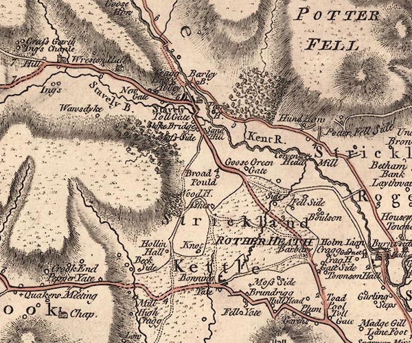 J5SD49NE.jpg  J5SD59SW.jpg double line; road, bold, main road, with mile numbers item:- National Library of Scotland : EME.s.47 Images © National Library of Scotland |
||
|
|
|||
| evidence:- | descriptive text:- West 1778 (11th edn 1821) |
||
| source data:- | Guide book, A Guide to the Lakes, by Thomas West, published by
William Pennington, Kendal, Cumbria once Westmorland, and in
London, 1778 to 1821. goto source Page 56:- "..." "... to the horse-ferry on Windermere-water, four miles. On horseback, this latter is the more eligible rout (sic), as it leads immediately to the centre of the lake, where all its beauties are seen to the greatest advantage." "..." "The road to the ferry is round the head of Esthwaite-water, through the villages of Colthouse and Sawreys. Ascend a steep" goto sourcePage 57:- "hill, and from its summit, have a view of a long reach of Windermere-water, stretching far to the south, till lost between two high promontories. The road serpentizes round a rocky mountain, till you come under a broken scar, that in some places hangs over the way, and where ancient yews and hollies grow fantastically amongst the fallen rocks. ..." |
||
|
|
|||
| evidence:- | old map:- Crosthwaite 1783-94 (Win/Ble) |
||
| source data:- | Map, uncoloured engraving, An Accurate Map of the Grand Lake of
Windermere, scale about 2 inches to 1 mile, by Peter
Crosthwaite, Keswick, Cumberland, 1783, version published 1819. CT9SD39X.jpg "To Hawkshead" from the ferry landing on the west shore; and unlabelled road to Ferry Nab on the east shore. item:- Armitt Library : 2008.14.102 Image © see bottom of page |
||
|
|
|||
| evidence:- | old map:- Clarke 1787 map (Windermere N) |
||
| source data:- | Map, A Map of the Northern Part of the Lake Winandermere and its
Environs, scale about 6.5 ins to 1 mile, by James Clarke,
engraved by Samuel John Neele, 352 Strand, published by James
Clarke, Penrith, Cumberland and in London etc, 1787.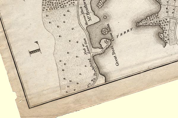 CLASD39X.jpg 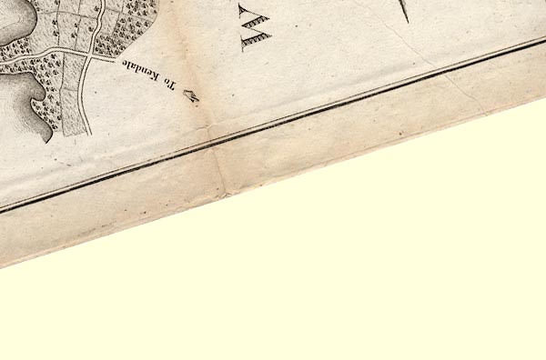 CLASD49C.jpg "To Kendale" item:- private collection : 10.10 Image © see bottom of page |
||
|
|
|||
| evidence:- | old map:- Clarke 1787 map (Windermere S) |
||
| source data:- | Map, A Map of the Southern Part of the Lake Winandermere and its
Environs, scale about 6.5 ins to 1 mile, by James Clarke,
engraved by Samuel John Neele, 352 Strand, published by James
Clarke, Penrith, Cumberland and in London etc, 1787.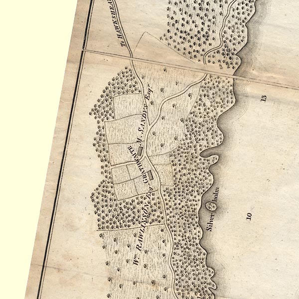 CLBSD39Q.jpg "To HAWKSHEAD" item:- private collection : 10.11 Image © see bottom of page |
||
|
|
|||
| evidence:- | old map:- Cary 1789 (edn 1805) |
||
| source data:- | Map, uncoloured engraving, Westmoreland, scale about 2.5 miles
to 1 inch, by John Cary, London, 1789; edition 1805. CY24SD39.jpg 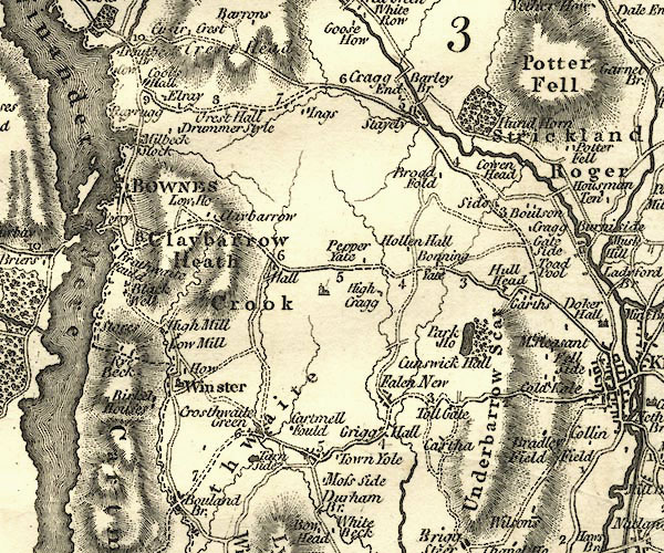 CY24SD49.jpg 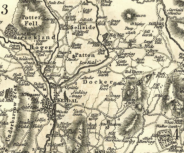 CY24SD59.jpg double line, bold light, numbered miles; main road item:- JandMN : 129 Image © see bottom of page |
||
|
|
|||
| evidence:- | road map:- Cary 1790 (Wmd/edn 1792) |
||
| source data:- | Road map, hand coloured engraving, Westmoreland, scale about
11.5 miles to 1 inch, by John Cary, 181 Strand, London, 1790,
edn 1792.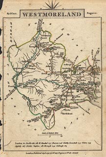 click to enlarge click to enlargeCY16.jpg double line, with road distances from Kendal item:- JandMN : 44 Image © see bottom of page |
||
|
|
|||
| evidence:- | road book:- Cary 1798 (2nd edn 1802) |
||
| source data:- | Road book, itineraries, Cary's New Itinerary, by John Cary, 181
Strand, London, 2nd edn 1802. goto source click to enlarge click to enlargeC38319.jpg page 319-320 item:- JandMN : 228.1 Image © see bottom of page |
||
|
|
|||
| evidence:- | old map:- Laurie and Whittle 1806 |
||
| source data:- | Road map, Completion of the Roads to the Lakes, scale about 10
miles to 1 inch, by Nathaniel Coltman? 1806, published by Robert
H Laurie, 53 Fleet Street, London, 1834. click to enlarge click to enlargeLw18.jpg bold line; 'Principal Travelling Roads' item:- private collection : 18.18 Image © see bottom of page |
||
|
|
|||
| evidence:- | old map:- Cooper 1808 |
||
| source data:- | Map, hand coloured engraving, Westmoreland ie Westmorland, scale
about 9 miles to 1 inch, by H Cooper, 1808, published by R
Phillips, Bridge Street, Blackfriars, London, 1808. click to enlarge click to enlargeCOP4.jpg double line; road item:- Dove Cottage : 2007.38.53 Image © see bottom of page |
||
|
|
|||
| evidence:- | old map:- Wallis 1810 (Wmd) |
||
| source data:- | Road map, Westmoreland, scale about 19 miles to 1 inch, by James
Wallis, 77 Berwick Street, Soho, 1810, published by W Lewis,
Finch Lane, London, 1835? click to enlarge click to enlargeWAL5.jpg double line, light bold; 'Turnpike Road' item:- JandMN : 63 Image © see bottom of page |
||
|
|
|||
| evidence:- | old map:- Hall 1820 (Wmd) |
||
| source data:- | Map, hand coloured engraving, Westmoreland ie Westmorland, scale
about 14.5 miles to 1 inch, by Sidney Hall, London, 1820,
published by Samuel Leigh, 18 Strand, London, 1820-31. click to enlarge click to enlargeHA18.jpg single line, solid; minor road; Kendal, Brundrigg, Claybarrow, Windermere Ferry, ... item:- Armitt Library : 2008.14.58 Image © see bottom of page |
||
|
|
|||
| evidence:- | old map:- Prior 1874 map 1 |
||
| source data:- | Map, uncoloured engraving or lithograph? Winander Mere, scale
about 2.5 miles to 1 inch, published by John Garnett,
Windermere, Westmorland, 1874. click to enlarge click to enlargePI03M1.jpg "To Hawkshead / To Kendal" double line; road item:- private collection : 133.1 Image © see bottom of page |
||
|
|
|||
| evidence:- | gradient diagram:- Gall and Inglis 1890s-1900s (Roads) |
||
| source data:- | Contour Road Book of England, Northern Division, by Harry R G Inglis, published by
Gall and Inglis, 25 Paternoster Square, London and Edinburgh, 1898.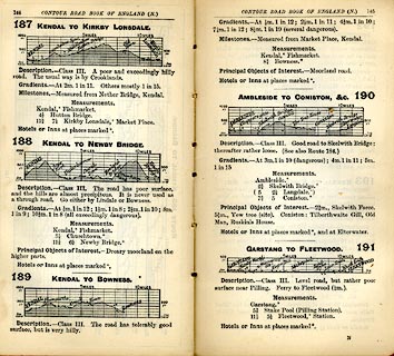 click to enlarge click to enlargeIG5187.jpg Itinerary, with gradient diagram, routes 187, Kendal to Kirkby Lonsdale, 188, Kendal to Newby Bridge, 189, Kendal to Bowness, and 190, Ambleside to Coniston etc, Westmorland and Lancashire, 1898. item:- JandMN : 763.19 Image © see bottom of page |
||
|
|
|||
 Act of Parliament Act of Parliament |
|||
|
|
|||
| places:- | Kendal Plumgarths, Strickland Ketel [Bonning Gate Turn Pike, Crook] Crook[Windermere Ferry, Windermere] Far Sawrey, Claife Near Sawrey, Claife Hawkshead |
||
|
|
|||
Lakes Guides menu.