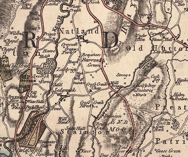
 Jefferys 1770 SD58NW

|

|
|
|
gazetteer links places may or may not be labelled on the map |
||

|
-- Barn (?) -- "Barn" |
|
|
|
-- Barrows Green -- "Barrows Green" |
|
|
|
-- Beehive Beck |
|
|
|
-- Beehive Bridge |
|
|
|
-- Beehive -- "Bee Hive" |
|
|
|
-- Bela, River -- "Beelo River" |
|
|
|
-- Bleasehall Wood |
|
|
|
-- Brayshaw -- "Brayshaw" |
|
|
|
-- Cockrigg -- "Cock Rig" |
|
|
|
-- Cracalt Farm -- "Cr[a]w Park" |
|
|
|
-- Crosscrake -- "Cross Craik Farm" |
|
|
|
-- Crow Park -- "Craycalt" |
|
|
|
-- End Moor -- "END MOOR" |
|
|
|
-- Force Bridge |
|
|
|
-- Garths -- "Garths" |
|
|
|
-- Gatebeck Bridge |
|
|
|
-- Gatebeck -- "Gate Beck" |
|
|
|
-- Grate -- "Grate" |
|
|
|
-- Halfpenny Farm -- "Pastures" |
|
|
|
-- Halfpenny -- "Halpenny" |
|
|
|
-- Hawes Bridge -- "Haws B." |
|
|
|
-- Hawes Farm -- "Haws Hole" |
|
|
|
-- Helm End -- "Helm End" |
|
|
|
-- Helm End -- "Helm End" |
|
|
|
-- High House -- "High H" |
|
|
|
-- Kent, River -- "Kent R." -- "Kent R." --
"KENT RIVER" |
|
|
|
-- Knotts -- "Knots" |
|
|
|
-- Larkrigg -- "Lackrigg" |
|
|
|
-- Levens Force -- "Forse" |
|
|
|
-- Low Barrows Green -- "Hole of Stainton" |
|
|
|
-- Low Park Wood |
|
|
|
-- Low Sizergh -- "Syzergh Hall Farm" |
|
|
|
-- milestone, Barrow Green -- "3" |
|
|
|
-- milestone, Helsington -- "2" |
|
|
|
-- milestone, Natland -- "2" |
|
|
|
-- milestone, Preston Richard -- "5" |
|
|
|
-- milestone, Stainton -- "4" |
|
|
|
-- Mill Bridge -- "Mill Briggs" |
|
|
|
-- Garths Mill (?) |
|
|
|
-- Millbridge House -- "Mill Briggs" |
|
|
|
-- Natland -- "Natland" |
|
|
|
-- New Sedgwick Gunpowder Mills -- "Mill" |
|
|
|
-- Park Head -- "Park Head" |
|
|
|
-- Prizet Farm -- "Prisate" |
|
|
|
-- Prizet -- "Prisate" |
|
|
|
-- Kendal to Kirkby Lonsdale-- Kendal to Kirkby Lonsdale |
|
|
|
-- Lancaster to Kendal -- "from Lancaster" |
|
|
|
-- Milnthorpe to Kendal |
|
|
|
-- Natland Road |
|
|
|
-- Stainton road |
|
|
|
-- Sedgwick -- "Sedgwick" |
|
|
|
-- Sellet Hall -- "Sellet Hall" |
|
|
|
-- St Mark's Church |
|
|
|
-- St Sunday's Beck |
|
|
|
-- St Thomas's Church -- "Croass Craik Chap" |
|
|
|
-- Stainton Bridge End -- "Bridge End" |
|
|
|
-- Stainton Bridge |
|
|
|
-- Stainton -- "Stainton" |
|
|
|
-- Stang -- "Stang" |
|
|
|
-- Strickley Beck |
|
|
|
-- Strickley -- "Str[i]ckley" |
|
|
|
-- Underhelm -- "Under Helm" |
|
|
|
-- waterfall, Sedgwick -- "Waterfalls" |
|
|
|
-- waterfall, Sedgwick -- "Waterfalls" |
|
|
|
-- Well Heads -- "Well Head" |
|
|
civil parishes The area roughly includes parts of parishes:- Helsington Levens Natland Sedgwick Hincaster Stainton Preston Richard Preston Patrick Old Hutton and Holmescales New Hutton |
||
|
|
||
|
|
Lakes Guides menu. | |