 Cary 1789

|

|
|
|
map type:- Cary 1789 |
|
|
|
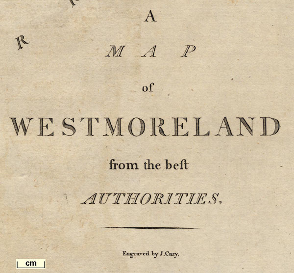
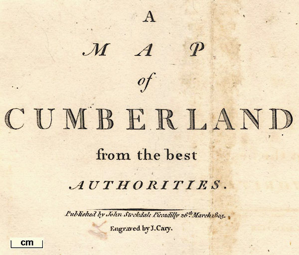
Maps, Map of Westmoreland, scale about 2.5 miles to 1
inch, and Map of Cumberland, scale about 3.5 miles to 1
inch, by John Cary, London, 1789; published 1789-1806.
and other county maps etc. Published in 'Britannia: or, a Chorographical Description of the flourishing kingdoms of England, Scotland, and Ireland, and the islands adjacent; from the earliest antiquity. By William Camden. Translated from the edition published by the author in MDCVII. Enlarged by the latest discoveries, by Richard Gough, ... illustrated with Maps ... London: Printed by John Nichols, for T. Payne and Son, Castle Street, St. Martin's and G. G. J. and J. Robinson, Pater-Noster-Row, MDCCLXXXIX.' 1789. The book is in three volumes with many illustrations as well as the maps; there is a map of Judges's circuits in Great Britain and Ireland, a map of England and Wales, a triangular distance table, etc; the atlas size is 10 x 17 ins. There is a map of Lancashire which includes areas now in Cumbria. In the atlas there are maps of Britannia Romana and Saxon England, which originate in the 1695 Gibson edition of Britannia. And there is a General Map of the Roman or Picts Wall. Published in 'New British Atlas, being a complete Set of County Maps, on which are delineated all the Roads, Cities, Towns, Villages, Rivers & Canals; together with correct general Maps of England, Wales, Scotland, & Ireland. London. Printed for John Stockdale, Piccadilly, 1805.' The atlas has title page, contents list, county maps and general country maps; its size is 13 1/4 x 20 ins. Published in a second edition of Gough's edition of 'Britannia ... London: Printed for John Stockdale, Piccadilly; By J. Nichols and Son, Red Lion Passage, Fleet Street, 1806.' the second edition is in four volumes; there are additional maps of 'Britannia Romana' and 'Saxon England' and a map of Hadrian's Wall. |
||
| see:- | Camden 1789 | |
|
(map example HMCMS:FA1999.5.48)
|
||
| map feature:- | compass rose & up is N & scale line & lat and long scales & coast form lines & rivers & lakes & relief & hill hachuring & woods & parks & county & wards (hundreds?) & table of wards (hundreds) & settlements & roads | |
| inscription:- |
printed lower right
A / MAP / of / WESTMORELAND / from the best / AUTHORITIES. / Engraved by J. Cary. |
|
| wxh, map:- | 487X398mm | |
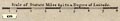
| scale:- | 1 to 150000 ? (1 to 152725 from scale line) | |
| scale line:- | 8 miles = 84.2 mm | |
|
||
|
||
| references:- |
Camden, William & Gough, Richard (trans): 1789: Britannia &
Chorographical Description of the flourishing kingdoms of
England, Scotland, and Ireland, A: Payne, T and Son &
Robinson, G G J and J (London) : 1805: New British Atlas: Stockdale, John (London) Camden, William & Gough, Richard (trans): 1806: Britannia & Chorographical Description of the flourishing kingdoms of England, Scotland, and Ireland, A: Stockdale, John (London) |
|
| sources:- |
Chubb 1927 (CCLXXI) HMCMS Map Collection JandMN Collection Wordsworth Trust Collection Armitt Library Kendal Library Maps Carlisle Library Maps |
|
| items seen (illustrated items in bold):- | ||

|
Armitt Library : A1213.2 -- map -- Map of Westmoreland | |
|
|
Armitt Library : A1213.3 -- map -- Map of Cumberland | |
|
|
Armitt Library : ALMC2008.14.127 -- map -- Map of Westmoreland | |
|
|
Armitt Library : ALMC2008.14.128 -- map -- Map of Westmoreland | |
|
|
Carlisle Library : Map 175 -- map -- Map of Westmoreland | |
|
|
Dove Cottage : 2007.38.32 -- map -- Map of Westmoreland -- Westmoreland | |
|
|
Hampshire Museums : FA1999.5.2 -- map -- Britannia Romana & Roman Britain | |
|
|
Hampshire Museums : FA1999.5.5 -- map -- Accurate Map of England and Wales, An | |
|
|
Hampshire Museums : FA1999.5.47 -- map -- Lancashire | |
|
|
Hampshire Museums : FA1999.5.48 -- map -- Map of Westmoreland | |
|
|
Hampshire Museums : FA1999.5.49 -- map -- Cumberland | |
|
|
Hampshire Museums : FA1999.5.50 -- map -- General Map of the Roman or Picts Walls | |
|
|
Hampshire Museums : FA1999.5.53 -- map -- Principal Roman Camps, Forts, Walls, between Tyne and Tay (shortened) & Principal Roman Camps, Forts, Walls, ... between the River Tyne in England, and Tay in Scotland | |
|
|
JandMN (128) -- map -- Map of Cumberland | |
|
|
JandMN (129) -- map -- Map of Westmoreland | |
|
|
Kendal Library : Map 75 -- map -- Map of Westmoreland | |
|
|
Kendal Library : Map 76 -- map -- Map of Westmoreland | |
|
|
private collection (291) -- map -- Map of the North Part of the West Riding of Yorkshire -- West Riding of Yorkshire | |