 Cary 1789

|

|
|
|
item:- Hampshire Museums : FA1999.5.48 image:- © see bottom of page |
click to enlarge |
|
|
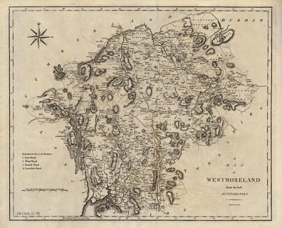
Map, uncoloured engraving, Westmoreland, scale about 2.5
miles to 1 inch, by John Cary, London, 1789.
Included in Britannia by William Camden, translated by Richard Gough, published by T Payne and Son, Castle Street, St Martin's and G G J and J Robinson, Pater-Noster-Row, London, 1789. |
||

|
Cary 1789 | |
| map feature:- | compass rose & up is N & scale line & lat and long scales & coast form lines & rivers & lakes & relief & hill hachuring & woods & parks & county & wards (hundreds?) & table of wards (hundreds) & settlements & roads | |
| inscription:- |
printed lower right
A / MAP / of / WESTMORELAND / from the best / AUTHORITIES. / Engraved by J. Cary. |
|
| inscription:- |
printed left
REFERENCES to the WARDS / 1. East Ward / 2. West Ward / 3. Kendal Ward / 4. Lonsdale Ward |
|
| inscription:- |
printed above scale line
Scale of Statute Miles 69 1/4 to a Degree of Latitude. |
|
| scale line:- | 8 miles = 84.2 mm | |
| wxh, map:- | 487x398mm | |
| scale:- | 1 to 150000 ? (1 to 152725 from scale line) | |
|
|
notes | |