 Cary 1789

|

|
|

|
back to object record | |
| MAP FEATURES | ||
|
|
||
|
title
map maker engraver |
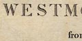
Printed lower right:- A MAP of WESTMORELAND from the best AUTHORITIES. Engraved by J. Cary. |
|
|
|
||
|
orientation
compass rose up is N |
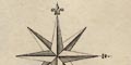
Printed upper left is a compass rose; no circle, star points for cardinal and half cardinal directions, North marked by a fleur de lys, East marked by an indeterminate symbol. The map is printed with North at the top of the sheet. |
|
|
|
||
|
scale line
scale |
Printed lower left is a:-
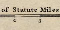
Scale of Statute Miles 69 1/4 to a Degree of Latitude. chequered and labelled in miles. The 8 miles = 84.2 mm gives a scale 1 to 152725. The map scale is about:- 1 to 150000 2.5 miles to 1 inch |
|
|
|
||
|
lat and long
lat and long scales |
Printed in the map borders are scales of latitude and longitude for a rectangular projection; chequered at 1 minute intervals, labelled at 5 minute intervals. The bottom scale is labelled:- Longitude West from London From the scales the longitude, Kendal = 2d 45m W suggesting a prime meridian at Greenwich. The map includes from 2d 6m to 3d 13m W, from 54d 11m to 54d 43m N; the whole of Westmorland. |
|
|
|
||
|
sea area
sea plain |
The small amount of sea area shown in the Kent Estuary is
plain.
|
|
|
|
||
|
coast line
coast form lines |
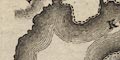
The coast line of the Kent Estuary is emphasised by form lines. |
|
|
|
||
|
rivers
bridges ferries |
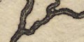
The lower reaches of rivers are drawn by double lines with form lines, which narrow to a single wiggly line tapering upstream. Major rivers with lots of tributaries are shown. Judging from the one area I know well. Longsleddale, the tributaries shown do not all match streams today. Rivers are nor particularly well labelled, but see:- Kent River Emont River Eden River Bridges are implied where a road crosses and interrupts a stream. A number of bridges are labelled, eg:- 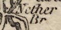
Nether Br [Kendal] Haws Br. [near Natland] Mint Br [Kendal] L. Burrow Bridge Emont Br. Roads approach the lake on two peninsulas into Windermere, labelled:- 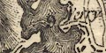
Ferry Road distances from Kendal demonstrate the continuity of the route; 8 on one side, 9 in the lake, 10 on the further shore. |
|
|
|
||
| lakes |
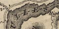
Lakes are drawn in outline with form lines, and may be labelled:- Blea Tarn [Langdale] Bletharn Tarn [Blelham Tarn] Broader Water [Brothers Water] Easted Water [Esthwaite Water] Elter Water Halls Water [Haweswater] Mazon Waith [Sunbiggin Tarn] Skegales Water [Skeggles Water] Tarn [Kentmere Tarn] ULLES WATER Winander Mere And other lakes and tarns might be recognised:- Angle Tarn [?] Cunswick Tarn Cow Green Tarn [? before it was a reservoir] Easedale Tarn Fisher Tarn Grasmere Hayeswater Loughrigg Tarn Out Dubs Tarn Rydal Water Stickle Tarn Terrybank Tarn [?] Whinfell Tarn [decoy pond, Lowther][twice?] |
|
|
|
||
|
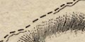
relief
hill hachuring |
Relief is indicated by hill hachuring, the usual patchy
marking of hills here and there. A number of hills are
labelled, eg:-
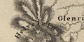
Helvelein Farlton Knot Underbarrow Scar Loughrigg Fell SHAP FELLS Some valleys are labelled, eg:- Swindale Grysdale And, although not always drawn as a pass, a pass might be labelled, eg:- Kirkstone Nan Bield The latter having a pillar or rock symbol. |
|
|
|
||
| beacons |
A hill north of Grayrigg is labelled:-
Beacon with nearby label:- Whinny Presumably Whinfell Beacon. Another hill is:- Barbon Beacon |
|
|
|
||
|
woods
forests trees |
Some woodland areas are indicated by tree symbols, for
example on the east shore of Windermere. Some forests are
labelled, eg:-
WHINFELL FOREST Martin Dale Forest and a few woods, eg:- Flake Bridge Wood [by Appleby] Labelled by a group of trees near Cliburn is:- 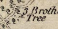
3 Brothers Tree |
|
|
|
||
| parks |
Parks are drawn in outline with fence palings, the
interior filled with trees. A park might be labelled, or
named by a great house, eg:-
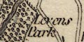
Levens Park Lowther [the church and castle shown] Wharton Park |
|
|
|
||
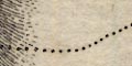
| county |
The county boundary is a dashed line, carried through lakes, alongside rivers, etc. Adjacent counties are labelled, eg:- CUMBERLAND Various features are shown outwith the county for continuity, as: the road on the Cumberland shore of Ullswater; Penrith; the area around Hawkshead; etc. Notice that part of Yorkshire, Sedbergh northward, is included in Westmorland by this map, the boundary following up the Rawthey instead of the Lune. The boundary between Lancashire and Yorkshire is not shown. An area on Stainmoor, north of the road to Barnard Castle, is enclosed by a dotted line and labelled:- Disputed Bounds There is a similar area further north in the Lune Forest, but not labelled. |
|
|
|
||
|
wards
table of wards |
Wards, comparable to hundreds, are bounded by a fine dotted line. The ward areas are labelled by number keying to a table printed lower left:- REFERENCES to the WARDS. 1. East Ward 2. West Ward 3. Kendal Ward 4. Lonsdale Ward |
|
|
|
||
|
settlements
street plan electoral data |
Settlements are marked by blocks, perhaps with a church
symbol, differentiated by style of labelling.
|
|
| towns |
blocks; perhaps arranged on a street plan, perhaps a
church symbol; labelled in upright block caps, eg:-
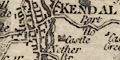
KENDAL BURTON in Kendal BOWNES [Windermere] SHAP Appleby has two stars indicating it returns two members to Parliament. |
|
| villages |
blocks, perhaps on a street, and a church symbol;
labelled in upright lowercase text, eg:-
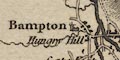
Bampton Orton Also notice that whole areas are labelled in this style, eg:- Sellside Docker Crook Without a detail analysis the judgement is unsound, but it seems that John cary was appreciated that there were non-nucleated settlements, which are difficult to plot and label. Notice also the lone chapels shown on the map. |
|
| hamlets |
block or blocks; labelled in italic lowercase text,
eg:-
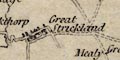
Great Strickland Natland |
|
| houses |
block, or a drawing of a house; labelled in italic
lowercase text, eg:-
Ewbarrow Hall [drawing of house with tower, Longsleddale] Ingshole [block, Tillshole, Longsleddale] Marthwaite [block, Longsleddale] 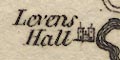
Levens Hall [building with two towers] |
|
| chapels |
A lone chapel might be marked by a church symbol,
labelled as:-
Chap Chapel Outside Sedbergh there is:- Quaker M. M for Meeting, this is at Brigflatts Meeting House. |
|
|
|
||
|
roads
turnpike roads road distances |
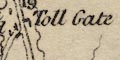
A network of roads is drawn by double line, solid or dotted for fenced and unfenced margins. Roads are graded, narrower for lesser roads, broader for greater roads which mostly have light bold lines, a common indicator of a turnpike. At Town Head, north of Grasmere on the road to Keswick, is labelled:- Toll Gate and there is another 3 miles west of Kendal on the road to Bowland Bridge etc. Distances are given in figures beside the road each mile from town to town. For example from Ambleside north are 14, 15, 16, 17, 18, 19, ... the last just past the toll bar. This series of numbers is counted from Kendal via Staveley, Troutbeck Bridge, etc - Windermere doesn't exist at the time of this map. Some road destinations are labelled at county boundaries, eg:- From Whitehaven From Lancaster To Barnard Castle |
|
|
|
||
| miscellaneous | ||
|
|
||
|
mills
water mills paper mills |
Mills seem to be marked in at least three different ways.
A circle with rays, representing a mill wheel, is used
beside the stream, eg:-
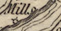
Mill [on Mint NNE of Kendal] Holm Mill [N of Burton] New Mill [N of Burton] A circle without rays, eg:- Paper Mill [tiny stream N of Kendal] A block, eg:- Facet Mill [NE of Tebay] |
|
|
|
||
|
mines
lead mines |
By Dufton Fell there are three circles labelled:-
Lead Mines |
|
|
|
||
|
mines
coal mines |
A circle S of Stainmoor Forest, at the end of Brownbin
Fell is labelled:-
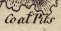
Coal Pits and a circle in Lune Forest, 4m NE of Brough is:- Leacet Colliery |
|
|
|
||
| inns |
A [very] few inns are noticed, eg:-
Punch Bowl [2m E of Brough] |
|
|
|
||
| pillars |
A drawing of a pillar (or standing stone, or ...) north
east of Dufton is labelled:-
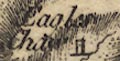
Eagles Ch[ ] and another on the south east boundary is:- Lady's Pillar |
|
|
|
||
|
antiquities
earthworks |
At Mayburgh there is label:-
Druids Temple and nearby, perhaps marked by a circle:- K. Arthurs Round Table |
|
|
|
||
|
antiquities
roman sites roman forts |
Across the road to Barnard Castle, at the county
boundary, is:-
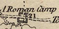
A Roman Camp marked by a plan of the walls. An outline of a small fort with corner turrets? on the same road, 23 1/2 from Barnard Castle, is labelled:- Maiden Castle |
|
|
|
||
|
antiquities
roman sites |
Roman placenames are mostly not noticed, but see:-
Gallatum north of Bolton by the Eden. |
|
Lakes Guides menu.