 Cary 1789

|

|
|
|
item:- JandMN (129) image:- © see bottom of page |
click to enlarge |
|
|
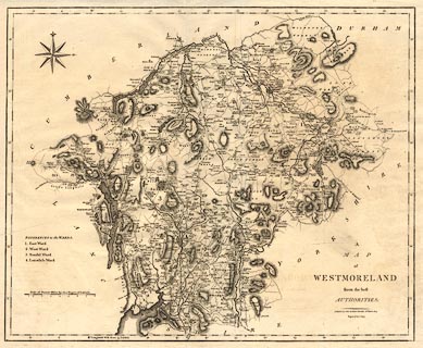
Map, uncoloured engraving, Westmoreland, scale about 2.5
miles to 1 inch, by John Cary, London, 1789; edition 1805.
First published in an edition of Camden's Britannia; this edition included in the New British Atlas, published by John Stockdale, Piccadilly, London, 1805. |
||

|
Cary 1789 | |
| map feature:- | compass rose & up is N & scale line & lat and long scales & coast form lines & rivers & lakes & relief & hill hachuring & woods & parks & county & wards (hundreds) & table of wards (hundreds) & settlements & roads | |
| inscription:- |
printed lower right
A / MAP / of / WESTMORELAND / from the best / AUTHORITIES. / Published by John Stockdale Piccadilly 26th. March 1805. / Engraved by J. Cary. |
|
| inscription:- |
printed left
REFERENCES to the WARDS / 1. East Ward / 2. West Ward / 3. Kendal Ward / 4. Lonsdale Ward |
|
| inscription:- |
printed above scale line
Scale of Statute Miles 69 1/4 to a Degree of Latitude. |
|
| scale line:- | 8 miles = 84.4 mm | |
| wxh, sheet:- | 54x43.5cm | |
| wxh, plate:- | 503x412mm | |
| wxh, map:- | 488x398mm | |
| scale:- | 1 to 150000 ? (1 to 152544 from scale line) | |
|
|
notes | |