Old Cumbria Gazetteer
 |
 |
|
||
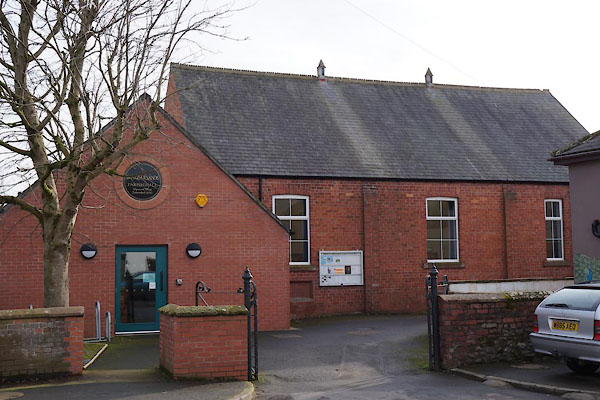
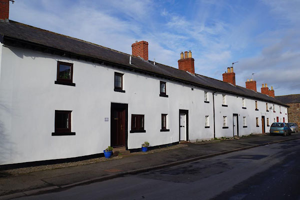
| Burgh by Sands | ||||
| Bruff | ||||
| locality:- | Hadrian's Wall | |||
| civil parish:- | Burgh by Sands (formerly Cumberland) | |||
| county:- | Cumbria | |||
| locality type:- | locality | |||
| locality type:- | buildings | |||
| coordinates:- | NY32755914 (etc) | |||
| 1Km square:- | NY3259 | |||
| 10Km square:- | NY35 | |||
|
|
||||
| evidence:- | old map:- OS County Series (Cmd 15 12) placename:- Burgh by Sands |
|||
| source data:- | Maps, County Series maps of Great Britain, scales 6 and 25
inches to 1 mile, published by the Ordnance Survey, Southampton,
Hampshire, from about 1863 to 1948. |
|||
|
|
||||
| evidence:- | old map:- Gough 1350s-60s placename:- Burgh Juxta Sablones |
|||
| source data:- | Map, colour photozincograph copy, reduced size facsimile, Gough
Map of Britain, scale about 28.5 miles to 1 inch, published by
the Ordnance Survey, Southampton, Hampshire, 1875. click to enlarge click to enlargeGgh1Cm.jpg item:- JandMN : 33 Image © see bottom of page |
|||
|
|
||||
| evidence:- | old map:- Gough 1350s-60s placename:- Burgh Juxta Sablones |
|||
| source data:- | Map, lithograph facsimile, Gough Map of Britain, 20 miles to 1
inch? published by the Ordnance Survey, Southampton, Hampshire,
1935. click to enlarge click to enlargeGgh2Cm.jpg item:- JandMN : 34 Image © see bottom of page |
|||
|
|
||||
| evidence:- | old map:- Lloyd 1573 placename:- Burg |
|||
| source data:- | Map, hand coloured copper plate engraving, Angliae Regni,
Kingdom of England, with Wales, scale about 24 miles to 1 inch, authored by Humphrey
Lloyd, Denbigh, Clwyd, drawn and engraved
by Abraham Ortelius, Netherlands, 1573. click to enlarge click to enlargeLld1Cm.jpg "Burg" item:- Hampshire Museums : FA1998.69 Image © see bottom of page |
|||
|
|
||||
| evidence:- | old map:- Saxton 1579 placename:- Burgh |
|||
| source data:- | Map, hand coloured engraving, Westmorlandiae et Cumberlandiae Comitatus ie Westmorland
and Cumberland, scale about 5 miles to 1 inch, by Christopher Saxton, London, engraved
by Augustinus Ryther, 1576, published 1579-1645.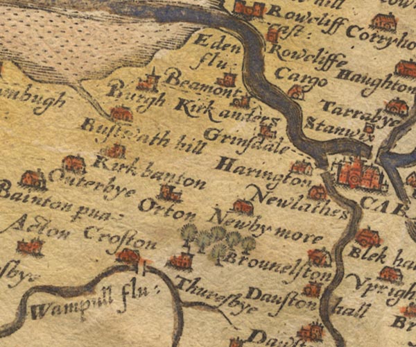 Sax9NY35.jpg Church, symbol for a parish or village, with a parish church. "Burgh" item:- private collection : 2 Image © see bottom of page |
|||
|
|
||||
| evidence:- | old map:- Mercator 1595 (edn?) placename:- Burg |
|||
| source data:- | Map, hand coloured engraving, Northumbria, Cumberlandia, et
Dunelmensis Episcopatus, ie Northumberland, Cumberland and
Durham etc, scale about 6.5 miles to 1 inch, by Gerard Mercator,
Duisberg, Germany, about 1595.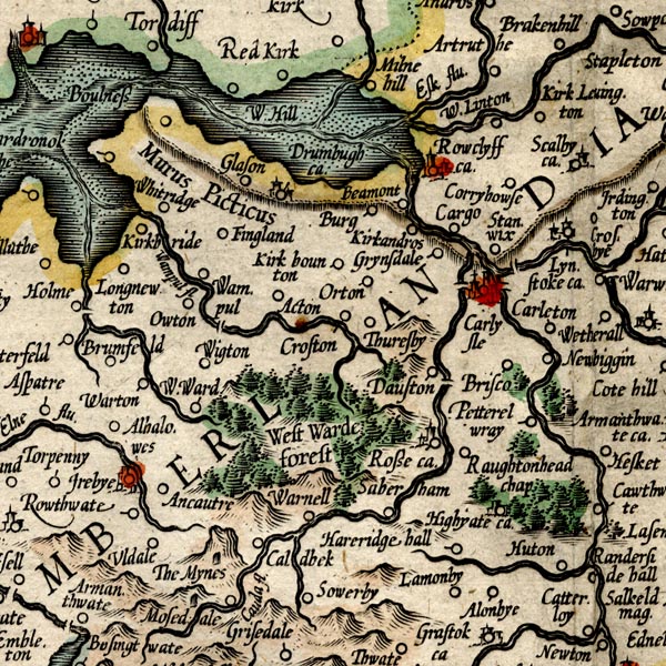 MER8CumC.jpg "Burg" circle item:- JandMN : 169 Image © see bottom of page |
|||
|
|
||||
| evidence:- | old map:- Speed 1611 (Cmd) placename:- Burgh Kirk |
|||
| source data:- | Map, hand coloured engraving, Cumberland and the Ancient Citie
Carlile Described, scale about 4 miles to 1 inch, by John Speed,
1610, published by J Sudbury and George Humble, Popes Head
Alley, London, 1611-12.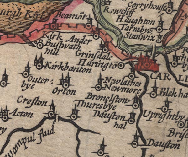 SP11NY35.jpg "Burgh Kirk" circle, buildings, tower item:- private collection : 16 Image © see bottom of page |
|||
|
|
||||
| evidence:- | old map:- Jansson 1646 placename:- Burgh Kirk |
|||
| source data:- | Map, hand coloured engraving, Cumbria and Westmoria, ie
Cumberland and Westmorland, scale about 3.5 miles to 1 inch, by
John Jansson, Amsterdam, Netherlands, 1646.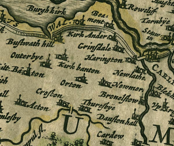 JAN3NY35.jpg "Burgh kirk" Buildings and tower. item:- JandMN : 88 Image © see bottom of page |
|||
|
|
||||
| evidence:- | old map:- Morden 1695 (Cmd) placename:- Burgh upon Sand |
|||
| source data:- | Map, uncoloured engraving, Cumberland, scale about 4 miles to 1
inch, by Robert Morden, 1695, published by Abel Swale, the
Unicorn, St Paul's Churchyard, Awnsham, and John Churchill, the
Black Swan, Paternoster Row, London, 1695-1715.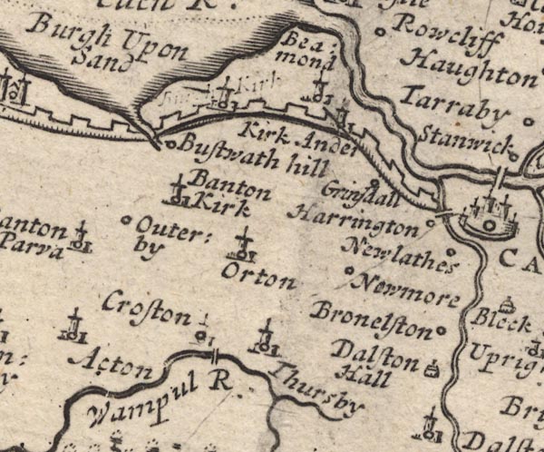 MD12NY35.jpg "Burgh Upon Sand" Circle, building and tower; there is also a deleted label. item:- JandMN : 90 Image © see bottom of page |
|||
|
|
||||
| evidence:- | old map, descriptive text:- Bowen 1720 (plate 162) placename:- Burgh upon Sands placename:- Castra Exploratum |
|||
| source data:- | Road book, Britannia Depicta Or Ogilby Improv'd, including road
strip maps with sections in Westmorland and Cumberland, scale
about 2 miles to 1 inch, derived from maps by Ogilby, 1675, also
a county map of Westmorland, scale about 8 miles to 1 inch, and
of Cumberland, scale about 16.5 miles to 1 inch, each with text,
by John Owen, published by Emanuel Bowen, London, 1720;
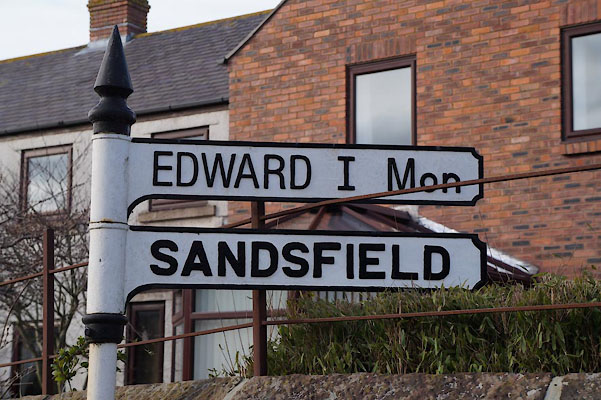
published 1720-64. "... Burgh upon Sands suppos'd to be the same with old Castra Exploratum, memorable on the account of ye renowned K: Ed. 1st. who seduced the Welsh, and marching with his Army against the Scotch dyed here in his Camp 7. Julÿa.d.1307." |
|||
|
|
||||
| evidence:- | old map:- Badeslade 1742 placename:- Burgh up Sand |
|||
| source data:- | Map, uncoloured engraving, A Map of Cumberland North from
London, scale about 11 miles to 1 inch, with descriptive text,
by Thomas Badeslade, London, engraved and published by William
Henry Toms, Union Court, Holborn, London, 1742. click to enlarge click to enlargeBD10.jpg "Burgh up Sand" circle, italic lowercase text; village, hamlet or locality item:- JandMN : 115 Image © see bottom of page |
|||
|
|
||||
| evidence:- | descriptive text:- Simpson 1746 placename:- Burgh upon Sands |
|||
| source data:- | Atlas, three volumes of maps and descriptive text published as
'The Agreeable Historian, or the Compleat English Traveller
...', by Samuel Simpson, 1746. goto source goto source"... The Romans had also another Station near this Place [Drumburgh Castle], which, by changing of the Name, is, at present called" "Burgh upon Sands, a large Barony, taking in all the neighbouring Lands and Town: It was first bestowed by Ranulph de Meschines, Lord of Cumberland, upon Robert de Estrivers, or Trivers, whom he made also chief Forester in his Forest of Englewood. From him, by" goto source"Marriage it came to Sir Hugh Morvil, whose Family enjoy'd it for some Time, and were called the Morvils of Burgh super sabulones: A Knight of this Family, named Hugh Morvil, was one of the four that kill'd Thomas Beckett, Archbishop of Canterbury; for which, being afterwards very penitent, he gave the Rectory of this Town to the Abbey of Holm Cultram, which the Bishops of Carlisle appropriated to the Monks." "The Sword with which he kill'd the Archbishop was kept long at Issal, and now remains in the Family of the Arundels. ..." goto source"The Inhabitants say, that under this Burgh in the very AEstuary, there was first a Sea Fight between the Scots and English; and when the Tide was out, a second Fight began between the Horse of both Sides, as strange as that which Pliny relates in Caramania, and makes a great Wonder of it: Into this AEstuary the Huna, or River Eden, having pass'd thro' Part of Westmoreland, and quite cross the N.E. Parts of the County, falls with a vast Body of Waters, which in the Year 1216, seemed to be the greatest Enemy that the Scots had, for when they had plunder'd the English without Resistance, and were returning with Loads of Spoil, they came upon them with a full Torrent, and quickly swallow'd up the whole plundering Crew." |
|||
|
|
||||
| evidence:- | old text:- Gents Mag placename:- Burgh on the Sands item:- roman altar |
|||
| source data:- | Magazine, The Gentleman's Magazine or Monthly Intelligencer or
Historical Chronicle, published by Edward Cave under the
pseudonym Sylvanus Urban, and by other publishers, London,
monthly from 1731 to 1922. goto source Gentleman's Magazine 1749 p.367 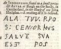 click to enlarge click to enlargeG7490367.jpg "An INSCRIPTION found on a small portable ALTAR at Burgh on the Sands, in Cumberland. in the house of one John Hodgson. - A reading of it is desired." |
|||
|
|
||||
| evidence:- | old map:- Bowen and Kitchin 1760 placename:- Burgh upon Sands |
|||
| source data:- | Map, hand coloured engraving, A New Map of the Counties of
Cumberland and Westmoreland Divided into their Respective Wards,
scale about 4 miles to 1 inch, by Emanuel Bowen and Thomas
Kitchin et al, published by T Bowles, Robert Sayer, and John
Bowles, London, 1760.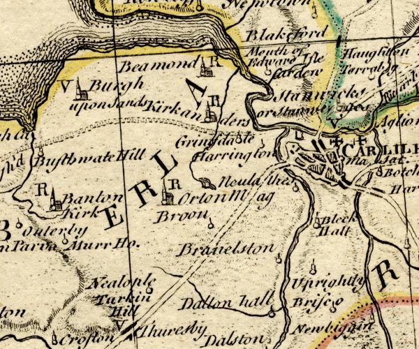 BO18NY35.jpg "Burgh upon Sands / V" circle, building and tower, vicarage item:- Armitt Library : 2008.14.10 Image © see bottom of page |
|||
|
|
||||
| evidence:- | old map:- Donald 1774 (Cmd) placename:- Burgh on the Sands |
|||
| source data:- | Map, hand coloured engraving, 3x2 sheets, The County of Cumberland, scale about 1
inch to 1 mile, by Thomas Donald, engraved and published by Joseph Hodskinson, 29
Arundel Street, Strand, London, 1774. D4NY35NW.jpg "Burgh on the Sands" blocks, and usually a church, labelled in upright lowercase; a village item:- Carlisle Library : Map 2 Image © Carlisle Library |
|||
|
|
||||
| evidence:- | old text:- Camden 1789 (Gough Additions) placename:- Burgh on Sands placename:- Burgh yn the Sand item:- roman altar; altar, roman; inscription, roman; roman inscription |
|||
| source data:- | Book, Britannia, or A Chorographical Description of the Flourishing Kingdoms of England,
Scotland, and Ireland, by William Camden, 1586, translated from the 1607 Latin edition
by Richard Gough, published London, 1789. goto source Page 187:- "..." "Burgh on Sands ... An altar inscribed," "DEO BELA TVCA" "was dug up in the vicar's garden; the 5th to that deity in England. Another inscription published in Gent. Mag. Aug. 1749, p.367, runs thus:" "ALA TVN P. PO. S: CENSORVVS SALVTE SVA ES [ET] POS." "On the spot where Edward I died, ..." "..." ""Burgh yn the sand standeth a mile off from the hither bank of Edon. It is a village by the which remain the ruins of a great place, now clene desolated, where king Edward the first died. Burgh" goto sourcePage 188:- ""stondith from Bolnes three miles and from Cair Luel four or five, and longid sometime to the Morvilles. Here was 15 years ago the lord Maxwell sore woundid, many slain and drowned in Edon." This relates to the battle of Sollom moss 1524." "Burgh belonged to the Lucys and Multons, and passed by the heiress of the latter to the Dacres of Dacre castle, to the coheiress of a younger branch of whom this barony was allotted, and her descendant in the 4th generation Henry Howard, duke of Norfolk, sold it about 1689 to sir John Lowther, bart. ancestor of the present possessor." |
|||
|
|
||||
| evidence:- | road book:- Cary 1798 (2nd edn 1802) placename:- Burgh |
|||
| source data:- | Road book, itineraries, Cary's New Itinerary, by John Cary, 181
Strand, London, 2nd edn 1802. goto source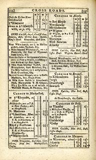 click to enlarge click to enlargeC38555.jpg page 555-556 "Burgh" item:- JandMN : 228.2 Image © see bottom of page |
|||
|
|
||||
| evidence:- | old map:- Laurie and Whittle 1806 placename:- Burgh on the Sands |
|||
| source data:- | Road map, Completion of the Roads to the Lakes, scale about 10
miles to 1 inch, by Nathaniel Coltman? 1806, published by Robert
H Laurie, 53 Fleet Street, London, 1834. click to enlarge click to enlargeLw18.jpg "Burgh on the Sands 311¼" village or other place; distance from London item:- private collection : 18.18 Image © see bottom of page |
|||
|
|
||||
| evidence:- | old map:- Cooper 1808 placename:- Burgh |
|||
| source data:- | Map, uncoloured engraving, Cumberland, scale about 10.5 miles to
1 inch, drawn and engraved by Cooper, published by R Phillips,
Bridge Street, Blackfriars, London, 1808. click to enlarge click to enlargeCOP3.jpg "Burgh" circle; village or hamlet item:- JandMN : 86 Image © see bottom of page |
|||
|
|
||||
| evidence:- | old text:- Gents Mag |
|||
| source data:- | Magazine, The Gentleman's Magazine or Monthly Intelligencer or
Historical Chronicle, published by Edward Cave under the
pseudonym Sylvanus Urban, and by other publishers, London,
monthly from 1731 to 1922. goto source Gentleman's Magazine 1816 part 2 p.600 From the Compendium of County History:- "1306, July 7, at Burgh-upon-Sands, EDWARD I. died." |
|||
|
|
||||
| evidence:- | old text:- Gents Mag 1819 item:- battle |
|||
| source data:- | goto source Gentleman's Magazine 1819 part 1 p.404 From the Compendium of County History:- "1016. Near Burgh-upon-Sands, Uchtred Earl of Northumberland and the Danes defeated by Malcolm King of Scotland." |
|||
|
|
||||
| evidence:- | old text:- Gents Mag 1819 |
|||
| source data:- | goto source Gentleman's Magazine 1819 part 1 p.405 "1307. ... on June 28, Edward, very weak and ill, left the city [Carlisle] on his March to Scotland; halted that night at Caldecote; reached Burgh-upon-Sands July 5, and closed his glorious reign there July 7. An obelisk commemorating this event was erected on Burgh Marsh by Henry Duke of Norfolk in 1685, and repaired by William Viscount Lowther in 1803. ..." |
|||
|
|
||||
| evidence:- | old map:- Ford 1839 map placename:- Burgh on the Sands |
|||
| source data:- | Map, uncoloured engraving, Map of the Lake District of
Cumberland, Westmoreland and Lancashire, scale about 3.5 miles
to 1 inch, published by Charles Thurnam, Carlisle, and by R
Groombridge, 5 Paternoster Row, London, 3rd edn 1843. FD02NY35.jpg "Burgh on the Sands" item:- JandMN : 100.1 Image © see bottom of page |
|||
|
|
||||
| evidence:- | old map:- Garnett 1850s-60s H placename:- Burgh |
|||
| source data:- | Map of the English Lakes, in Cumberland, Westmorland and
Lancashire, scale about 3.5 miles to 1 inch, published by John
Garnett, Windermere, Westmorland, 1850s-60s.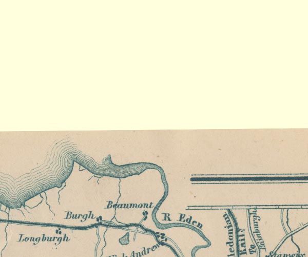 GAR2NY36.jpg "Burgh" blocks, settlement item:- JandMN : 82.1 Image © see bottom of page |
|||
|
|
||||
| evidence:- | old map:- Post Office 1850s-1900s placename:- Burgh |
|||
| source data:- | Post road maps, General Post Office Circulation Map for England
and Wales, for the General Post Office, London, 1850s-1900s. click to enlarge click to enlargePOF7Cm.jpg "Burgh" map date 1909 |
|||
|
|
||||
| evidence:- | old map:- Post Office 1850s-1900s placename:- Burgh |
|||
| source data:- | Post road maps, General Post Office Circulation Map for England
and Wales, for the General Post Office, London, 1850s-1900s. click to enlarge click to enlargePF10Cm.jpg "Burgh" map date 1892 |
|||
|
|
||||
| evidence:- | old map:- Post Office 1850s-1900s placename:- Burgh |
|||
| source data:- | Post road maps, General Post Office Circulation Map for England
and Wales, for the General Post Office, London, 1850s-1900s. click to enlarge click to enlargePOF2Cm.jpg "Burgh" map date 1890 |
|||
|
|
||||
| :- |
images courtesy of the British Postal Museum and Hampshire CC Museums |
|||
|
|
||||
| hearsay:- |
John Stagg, known as Blin' Stagg the Fiddler, was born here, 1770. His father was
a tailor. He was educated to be a clergyman, but lost his sight in an accident. He
played the fiddle and sang, and was in great demand for merry nights. |
|||
| There was a bakehouse for bread and tatie pots down Tatie Pot Alley. |
||||
|
|
||||
| places:- |
|
|||
|
||||
|
||||
|
||||
|
||||
|
||||
|
||||
|
||||
|
||||
|
||||
|
||||
|
||||
|
||||
|
||||
|
||||
|
||||
|
||||
|
||||
|
||||
|
||||
|
||||
|
||||
|
||||
|
||||
|
||||
|
||||
|
||||
|
||||
|
||||
|
||||
|
||||
|
||||
|
||||
|
||||
|
||||
|
||||
Lakes Guides menu.