 Old Cumbria Gazetteer
 |
 |
|
||||||||||||||||||||||||||||||||||||||||||||||||||||||||||||||||||||||||||||||||||||||||
| Skiddaw, Underskiddaw | ||||||||||||||||||||||||||||||||||||||||||||||||||||||||||||||||||||||||||||||||||||||||||
| Skiddaw | ||||||||||||||||||||||||||||||||||||||||||||||||||||||||||||||||||||||||||||||||||||||||||
| Skiddaw Man | ||||||||||||||||||||||||||||||||||||||||||||||||||||||||||||||||||||||||||||||||||||||||||
| Skidder | ||||||||||||||||||||||||||||||||||||||||||||||||||||||||||||||||||||||||||||||||||||||||||
| civil parish:- | Underskiddaw (formerly Cumberland) | |||||||||||||||||||||||||||||||||||||||||||||||||||||||||||||||||||||||||||||||||||||||||
| civil parish:- | Bassenthwaite (formerly Cumberland) | |||||||||||||||||||||||||||||||||||||||||||||||||||||||||||||||||||||||||||||||||||||||||
| county:- | Cumbria | |||||||||||||||||||||||||||||||||||||||||||||||||||||||||||||||||||||||||||||||||||||||||
| locality type:- | hill | |||||||||||||||||||||||||||||||||||||||||||||||||||||||||||||||||||||||||||||||||||||||||
| locality type:- | boundary feature | |||||||||||||||||||||||||||||||||||||||||||||||||||||||||||||||||||||||||||||||||||||||||
| locality type:- | parish boundary feature | |||||||||||||||||||||||||||||||||||||||||||||||||||||||||||||||||||||||||||||||||||||||||
| coordinates:- | NY26032909 | |||||||||||||||||||||||||||||||||||||||||||||||||||||||||||||||||||||||||||||||||||||||||
| 1Km square:- | NY2629 | |||||||||||||||||||||||||||||||||||||||||||||||||||||||||||||||||||||||||||||||||||||||||
| 10Km square:- | NY22 | |||||||||||||||||||||||||||||||||||||||||||||||||||||||||||||||||||||||||||||||||||||||||
| altitude:- | 3053 feet | |||||||||||||||||||||||||||||||||||||||||||||||||||||||||||||||||||||||||||||||||||||||||
| altitude:- | 931m | |||||||||||||||||||||||||||||||||||||||||||||||||||||||||||||||||||||||||||||||||||||||||
|
|
||||||||||||||||||||||||||||||||||||||||||||||||||||||||||||||||||||||||||||||||||||||||||
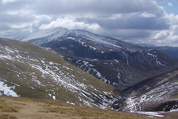 BSL65.jpg From NE (taken 4.4.2010) 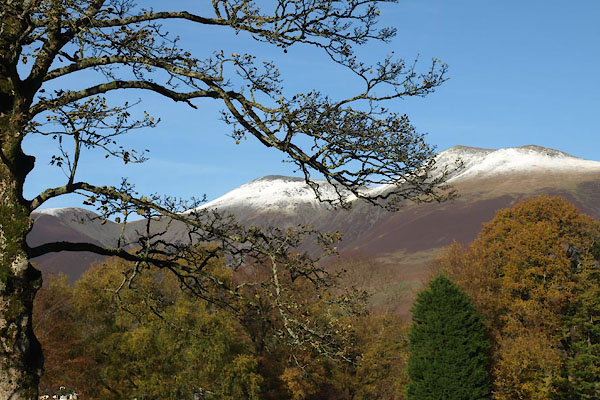 BXP67.jpg From Lower Fitz Park, Keswick. (taken 4.11.2012) 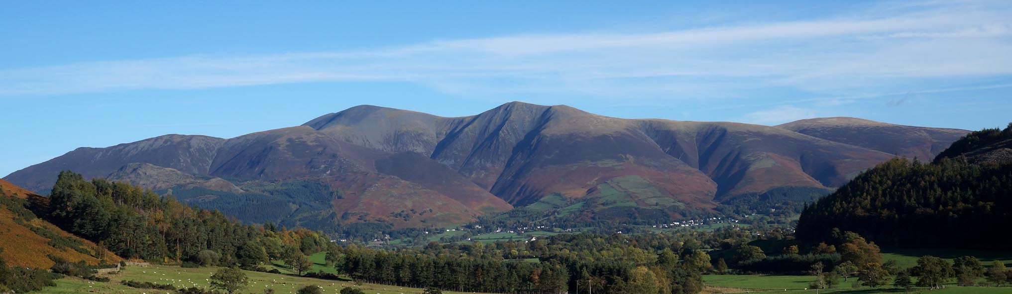 Click to enlarge BZO22.jpg From the south. (taken 24.10.2013) |
||||||||||||||||||||||||||||||||||||||||||||||||||||||||||||||||||||||||||||||||||||||||||
|
|
||||||||||||||||||||||||||||||||||||||||||||||||||||||||||||||||||||||||||||||||||||||||||
| evidence:- | old map:- OS County Series (Cmd 56 6) placename:- Skiddaw |
|||||||||||||||||||||||||||||||||||||||||||||||||||||||||||||||||||||||||||||||||||||||||
| source data:- | Maps, County Series maps of Great Britain, scales 6 and 25
inches to 1 mile, published by the Ordnance Survey, Southampton,
Hampshire, from about 1863 to 1948. |
|||||||||||||||||||||||||||||||||||||||||||||||||||||||||||||||||||||||||||||||||||||||||
|
|
||||||||||||||||||||||||||||||||||||||||||||||||||||||||||||||||||||||||||||||||||||||||||
| evidence:- | old map:- Mercator 1595 (edn?) placename:- Skiddow Hill |
|||||||||||||||||||||||||||||||||||||||||||||||||||||||||||||||||||||||||||||||||||||||||
| source data:- | Map, hand coloured engraving, Northumbria, Cumberlandia, et
Dunelmensis Episcopatus, ie Northumberland, Cumberland and
Durham etc, scale about 6.5 miles to 1 inch, by Gerard Mercator,
Duisberg, Germany, about 1595.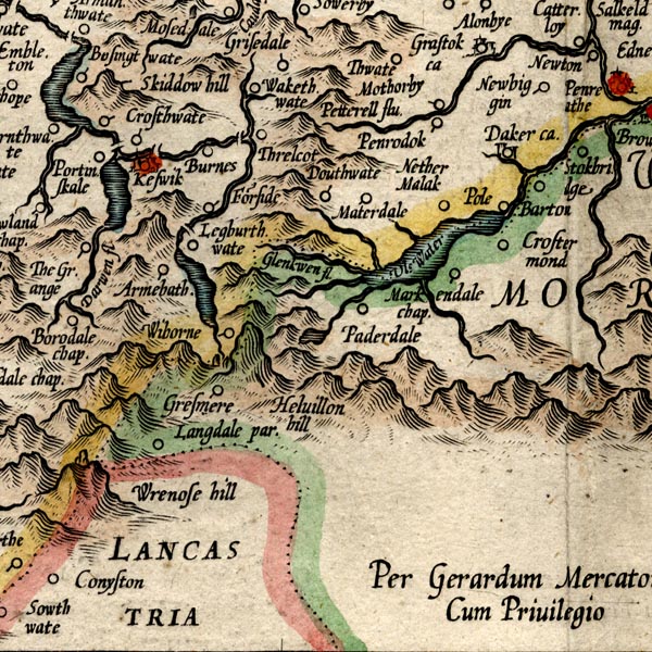 MER8CumF.jpg "Skiddow hill" hillock, shaded on east; hill or mountain item:- JandMN : 169 Image © see bottom of page |
|||||||||||||||||||||||||||||||||||||||||||||||||||||||||||||||||||||||||||||||||||||||||
|
|
||||||||||||||||||||||||||||||||||||||||||||||||||||||||||||||||||||||||||||||||||||||||||
| evidence:- | old map:- Speed 1611 (Cmd) placename:- Skiddow Hill |
|||||||||||||||||||||||||||||||||||||||||||||||||||||||||||||||||||||||||||||||||||||||||
| source data:- | Map, hand coloured engraving, Cumberland and the Ancient Citie
Carlile Described, scale about 4 miles to 1 inch, by John Speed,
1610, published by J Sudbury and George Humble, Popes Head
Alley, London, 1611-12.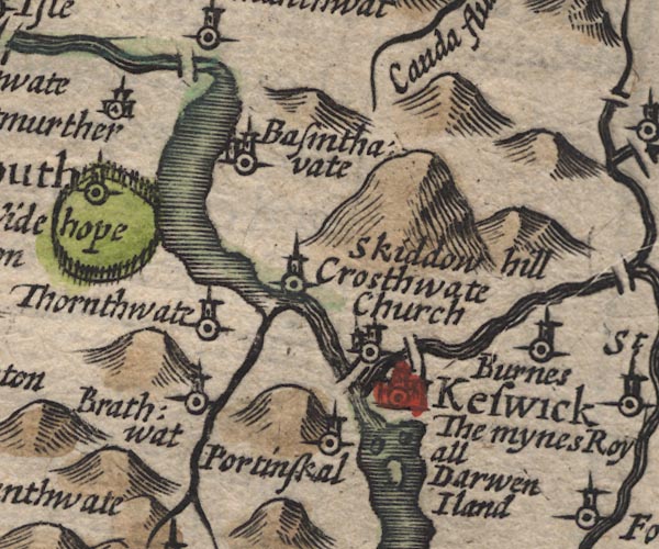 SP11NY22.jpg "Skiddow hill" a larger hillock item:- private collection : 16 Image © see bottom of page |
|||||||||||||||||||||||||||||||||||||||||||||||||||||||||||||||||||||||||||||||||||||||||
|
|
||||||||||||||||||||||||||||||||||||||||||||||||||||||||||||||||||||||||||||||||||||||||||
| evidence:- | poem:- Drayton 1612/1622 text placename:- Skiddo item:- viewpoint; clouds; weather signs |
|||||||||||||||||||||||||||||||||||||||||||||||||||||||||||||||||||||||||||||||||||||||||
| source data:- | Poem, Poly Olbion, by Michael Drayton, published by published by
John Marriott, John Grismand and Thomas Dewe, and others?
London, part 1 1612, part 2 1622. goto source goto sourcepage 165:- "When the Cambrian Hills, proud Skiddo that doth show The high'st, respecting whom, the others be but low, Perceiving with the Floods, and Forrests, how it far'd, And all their severall tales substantially had heard, And of the Mountaine kind, as of all other he, Most like Parnassus selfe that is suppos'd to be, Having a double head, as doth that sacred Mount, Which those nine sacred Nymphs held in so hie account, Bethinketh of himselfe what he might justly say, When to them all he thus his beaties doth display." "The rough Hibernian sea, I proudly overlooke, Amongst the scattered Rocks, and there is not a nooke, But from my glorious height into its depths I pry, Great Hills farre under me but as my Pages lye; And when my Helme of Clouds upon my head I take, At very sight thereof, immediately I make Th'Inhabitants about, tempestuous stormes to feare, And for faire weather looke, when as my top is cleere; Great Fournesse mighty Fells, I on my South survay: So likewise on the North, Albania makes me way, Her Countries to behold, when Scurfell from the skie, That Anadale doth crowne, with a most amorous eye, Salutes me every day, or at my pride lookes grim, Oft threatning me with Clouds, as I oft threatning him: So likewise in the East, that row of Mountaines tall, Which we our English Alpes may very aptly call, That Scotland here with us, and England doe divide, As those, whence we them name upon the other side," goto sourcepage 166:- "That looke farre off like clouds, shap't with embattelled towers, Doe Italy, and France, these Mountaines here of ours, Much envy my estate, and somewhat higher be, By lifting up their heads, to stare and gaze at me. Cleere Darwent dancing on, I looke at from above, As some enamoured Youth, being deeply struck in love, His Mistris doth behold, and every beautie notes; Who as shee to her fall, through Fells and Vallies flotes, Oft lifts her limber selfe above her Banks to view, How my brave by clift top, doth still her Course pursue. O all ye Topick Gods, that doe inhabit here, To whom the Romans did, those ancient Altars reare, Oft found upon those Hills, now sunke into the Soyles, Which they for Trophies left of their victorious spoyles, Ye Genii of these Floods, these Mountaines, and these Dales, That with poore Shepheards Pipes, &harmlesse Heardsmans tales Have often pleased been, still guard me day and night, And hold me Skidow still, the place of your delight." |
|||||||||||||||||||||||||||||||||||||||||||||||||||||||||||||||||||||||||||||||||||||||||
|
|
||||||||||||||||||||||||||||||||||||||||||||||||||||||||||||||||||||||||||||||||||||||||||
| evidence:- | old map:- Drayton 1612/1622 placename:- Skiddow Hill |
|||||||||||||||||||||||||||||||||||||||||||||||||||||||||||||||||||||||||||||||||||||||||
| source data:- | Map, hand coloured engraving, Cumberlande and Westmorlande, by
Michael Drayton, probably engraved by William Hole, scale about
4 or 5 miles to 1 inch, published by John Mariott, John
Grismand, and Thomas Dewe, London, 1622.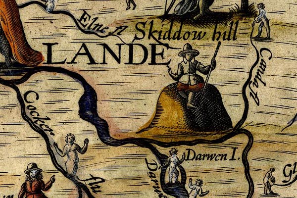 DRY509.jpg "Skiddow hill" Hillock, a gentleman sitting on top, with a staff. item:- JandMN : 168 Image © see bottom of page |
|||||||||||||||||||||||||||||||||||||||||||||||||||||||||||||||||||||||||||||||||||||||||
|
|
||||||||||||||||||||||||||||||||||||||||||||||||||||||||||||||||||||||||||||||||||||||||||
| evidence:- | old map:- Jansson 1646 placename:- Skiddow Hill |
|||||||||||||||||||||||||||||||||||||||||||||||||||||||||||||||||||||||||||||||||||||||||
| source data:- | Map, hand coloured engraving, Cumbria and Westmoria, ie
Cumberland and Westmorland, scale about 3.5 miles to 1 inch, by
John Jansson, Amsterdam, Netherlands, 1646. JAN3NY22.jpg "Skiddow hill" Large lumpy hillock. item:- JandMN : 88 Image © see bottom of page |
|||||||||||||||||||||||||||||||||||||||||||||||||||||||||||||||||||||||||||||||||||||||||
|
|
||||||||||||||||||||||||||||||||||||||||||||||||||||||||||||||||||||||||||||||||||||||||||
| evidence:- | old map:- Morden 1695 (Cmd) placename:- Skiddow Hill |
|||||||||||||||||||||||||||||||||||||||||||||||||||||||||||||||||||||||||||||||||||||||||
| source data:- | Map, uncoloured engraving, Cumberland, scale about 4 miles to 1
inch, by Robert Morden, 1695, published by Abel Swale, the
Unicorn, St Paul's Churchyard, Awnsham, and John Churchill, the
Black Swan, Paternoster Row, London, 1695-1715. MD12NY22.jpg "Skiddow Hill" Hillock, a little larger. item:- JandMN : 90 Image © see bottom of page |
|||||||||||||||||||||||||||||||||||||||||||||||||||||||||||||||||||||||||||||||||||||||||
|
|
||||||||||||||||||||||||||||||||||||||||||||||||||||||||||||||||||||||||||||||||||||||||||
| evidence:- | descriptive text:- Simpson 1746 placename:- Skiddaw, The item:- altitude, mountains |
|||||||||||||||||||||||||||||||||||||||||||||||||||||||||||||||||||||||||||||||||||||||||
| source data:- | Atlas, three volumes of maps and descriptive text published as
'The Agreeable Historian, or the Compleat English Traveller
...', by Samuel Simpson, 1746. goto source "..." "Some of the Mountains in Cumberland are very remarkable for their Height, viz. ... Secondly, the Skiddaw, a Mountain that rises up with two mighty high Heads like Parnassus, and from which Scruffel Hill, which is in Anandale in Scotland, may be discerned; and according as Mists rise or fall upon these Heads, the People there prognosticate of the Change of Weather. ... The third is Lauvellin, the fourth Castinand, of which, and the former, they have a proverbial Speech among them:" "Skiddaw, Lauvellin, and Castinand," "Are th' highest Hills in all England." |
|||||||||||||||||||||||||||||||||||||||||||||||||||||||||||||||||||||||||||||||||||||||||
|
|
||||||||||||||||||||||||||||||||||||||||||||||||||||||||||||||||||||||||||||||||||||||||||
| evidence:- | old map:- Gents Mag 1747 placename:- Skiddow Mount |
|||||||||||||||||||||||||||||||||||||||||||||||||||||||||||||||||||||||||||||||||||||||||
| source data:- | Map, uncoloured engraving, perspective view, Caudbeck Fells ie
Caldbeck Fells, scale about 1+ miles to 1 inch, published in the
Gentleman's Magazine, 1747.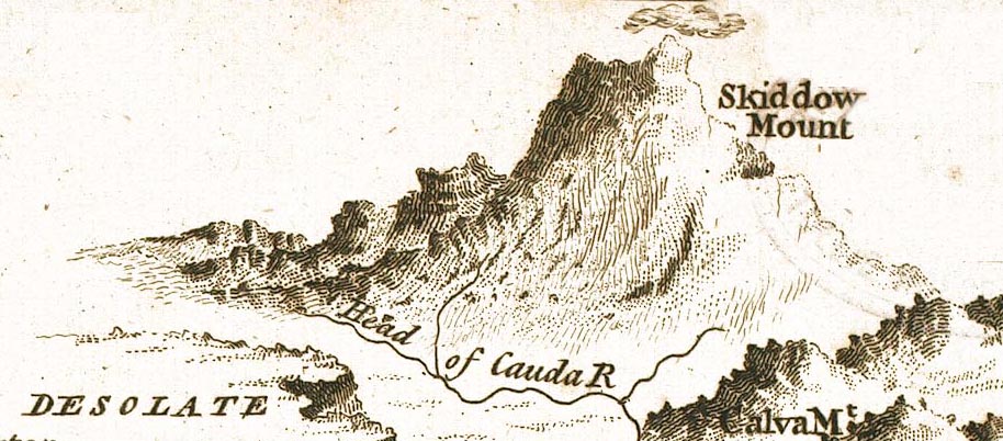 GM1408.jpg "Skiddow Mount" knobbly hillocks; mountains, capped by a cloud item:- Carlisle Library : Map 43 Image © Carlisle Library |
|||||||||||||||||||||||||||||||||||||||||||||||||||||||||||||||||||||||||||||||||||||||||
|
|
||||||||||||||||||||||||||||||||||||||||||||||||||||||||||||||||||||||||||||||||||||||||||
| evidence:- | old text:- Gents Mag |
|||||||||||||||||||||||||||||||||||||||||||||||||||||||||||||||||||||||||||||||||||||||||
| source data:- | Magazine, The Gentleman's Magazine or Monthly Intelligencer or
Historical Chronicle, published by Edward Cave under the
pseudonym Sylvanus Urban, and by other publishers, London,
monthly from 1731 to 1922. goto source Gentleman's Magazine 1748 p.292 "VIEW of Mount Skiddow and the neighbouring Fells from Ierby." 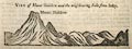 click to enlarge click to enlargeG748E02.jpg |
|||||||||||||||||||||||||||||||||||||||||||||||||||||||||||||||||||||||||||||||||||||||||
|
|
||||||||||||||||||||||||||||||||||||||||||||||||||||||||||||||||||||||||||||||||||||||||||
| evidence:- | old text:- Gents Mag placename:- Skiddow item:- snow |
|||||||||||||||||||||||||||||||||||||||||||||||||||||||||||||||||||||||||||||||||||||||||
| source data:- | Magazine, The Gentleman's Magazine or Monthly Intelligencer or
Historical Chronicle, published by Edward Cave under the
pseudonym Sylvanus Urban, and by other publishers, London,
monthly from 1731 to 1922. goto source Gentleman's Magazine 1749 p.283 "Extract of a letter from the North." "June 3. Snow lay till 7 in the morning, particularly near Carlisle." "June 15. A great snow fell on mount Skiddow, and lay till 3 in the afternoon." "..." |
|||||||||||||||||||||||||||||||||||||||||||||||||||||||||||||||||||||||||||||||||||||||||
|
|
||||||||||||||||||||||||||||||||||||||||||||||||||||||||||||||||||||||||||||||||||||||||||
| evidence:- | old text:- Gents Mag placename:- Skiddow item:- slate quarrying; flower |
|||||||||||||||||||||||||||||||||||||||||||||||||||||||||||||||||||||||||||||||||||||||||
| source data:- | Magazine, The Gentleman's Magazine or Monthly Intelligencer or
Historical Chronicle, published by Edward Cave under the
pseudonym Sylvanus Urban, and by other publishers, London,
monthly from 1731 to 1922. goto source Gentleman's Magazine 1751 p.51 Report of a visit to the black lead mines above Seathwaite, by GS, George Smith, published in the Gentleman's Magazine, London, February 1751. "THE Gentleman's Magazine: For FEBRUARY 1751." "Mr URBAN," "... Skiddow. This mountain, which I had visited the year before, and of which I have already given you some account (See V.XVIII. p.4) is a fissile absorbing slate: This slate is flaked off with a kind of wedge, peculiarly adapted to the work, in quarries near the top of the mountain, and is conveyed down to the plain by laborers, in a machine so contrived as to be carried upon the shoulder, the man walking upright: In these machines each man carries as much as would load a Cumberland cart, but having by long use learnt to improve the advantage afforded by the declivity of the mountain, they descend with little labour, and less hazard." "Skiddow is undoubtedly one of the highest mountains in Britain, the declivity from the white-water dash, at the foot, to the summit, measures near 5000 yards, but the perpendicular height cannot be much more then one fourth of that measure. The neighbouring mountains are all very high, and the greater part terminate in craggy precipices, that" |
|||||||||||||||||||||||||||||||||||||||||||||||||||||||||||||||||||||||||||||||||||||||||
|
|
||||||||||||||||||||||||||||||||||||||||||||||||||||||||||||||||||||||||||||||||||||||||||
| evidence:- | old text:- Gents Mag 1751 |
|||||||||||||||||||||||||||||||||||||||||||||||||||||||||||||||||||||||||||||||||||||||||
| source data:- | Map of the Black Lead Mines in Cumberland, and area, scale about 2 miles to 1 inch,
by George Smith, published in the Gentleman's Magazine, 1751. goto source Gentleman's Magazine 1751 p.52 "have the appearance of huge fragments of rock, irregularly heaped on one another; but in the prospect round, nature has lavished such variety of beauty as can scarce be believed upon report, or imagined by the most luxuriant fancy. The plains of Basingthwaite, watered by a fine lake, appear like a paradise to the West; and the islands that lie interspersed among the windings of Darwent, and the lake of Keswic, exceed description; beyond these, to the South, lie the mountains of Barrowdale, which are yet higher than Skiddow: The western seas, the Isle of Man, all the South coast of Scotland, and the mountains of Pennygent and Ingleborough, in Yorkshire, diversify other parts of this delightful landscape. The spot upon which I stood is one intire shiver of slate, and the precipice to the westward is frightful. The plants of Skiddow are the myrtle berries, generally called blackberries, the vitis idaea of Dioscorides, mossberries, great variety of mosses, and among others the muscus squammosus pulcher digitatus of Tournefort." |
|||||||||||||||||||||||||||||||||||||||||||||||||||||||||||||||||||||||||||||||||||||||||
|
|
||||||||||||||||||||||||||||||||||||||||||||||||||||||||||||||||||||||||||||||||||||||||||
| evidence:- | old map:- Gents Mag 1751 placename:- Mount Skiddow |
|||||||||||||||||||||||||||||||||||||||||||||||||||||||||||||||||||||||||||||||||||||||||
| source data:- | Map, uncoloured engraving, Map of the Black Lead Mines in
Cumberland, and area, scale about 2 miles to 1 inch, by George
Smith, published in the Gentleman's Magazine, 1751.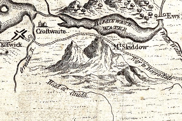 GM1314.jpg "Mt. Skiddow" knobbly hillocks; mountains item:- JandMN : 114 Image © see bottom of page |
|||||||||||||||||||||||||||||||||||||||||||||||||||||||||||||||||||||||||||||||||||||||||
|
|
||||||||||||||||||||||||||||||||||||||||||||||||||||||||||||||||||||||||||||||||||||||||||
| evidence:- | old text:- Morgan 1759 placename:- Skiddow |
|||||||||||||||||||||||||||||||||||||||||||||||||||||||||||||||||||||||||||||||||||||||||
| source data:- | MG02q014.txt "The traveller who visits Keswick should by no means omit the opportunity of gaining the summit of mount Skiddow, even though, by the winding passes he will be obliged to make, it will cost him a laborious ascent of five miles; but the prospect from this eminence will amply reward his fatigue. From the south east is a view over the tops of mountains, one succeeding to or overlooking the other: a scene of chaos and mighty confusion. This was the prospect which Dr. Brown described by the image of a tempestuous sea of mountains. Below it lies the lake, with all the beauties of its margin, together with the vale of Keswick, and the waters of Bassenthwaite, as if delineated on a chart. To the south, the hills towards Cockermouth, tho' less rugged and romantic than those towards the south-east, are yet no less stupendous. To the north-east is a prospect of a wide and barren heath, extending its plain to Carlisle, and terminated by the mountains of Scotland. To the north-east is a prospect of that spacious circus in which Penrith stands, the queen of the vale, overtopped by Cross fell, which forms the most dis-" "tant" MG02q015.txt "[dis]tant back ground. Skiddow is said to be, from the plane of the lake's surface, 3450 feet in perpendicular height." |
|||||||||||||||||||||||||||||||||||||||||||||||||||||||||||||||||||||||||||||||||||||||||
|
|
||||||||||||||||||||||||||||||||||||||||||||||||||||||||||||||||||||||||||||||||||||||||||
| evidence:- | old map:- Bowen and Kitchin 1760 placename:- Skiddaw |
|||||||||||||||||||||||||||||||||||||||||||||||||||||||||||||||||||||||||||||||||||||||||
| source data:- | Map, hand coloured engraving, A New Map of the Counties of
Cumberland and Westmoreland Divided into their Respective Wards,
scale about 4 miles to 1 inch, by Emanuel Bowen and Thomas
Kitchin et al, published by T Bowles, Robert Sayer, and John
Bowles, London, 1760. BO18NY22.jpg "Skiddaw" hill hachuring item:- Armitt Library : 2008.14.10 Image © see bottom of page |
|||||||||||||||||||||||||||||||||||||||||||||||||||||||||||||||||||||||||||||||||||||||||
|
|
||||||||||||||||||||||||||||||||||||||||||||||||||||||||||||||||||||||||||||||||||||||||||
| evidence:- | old map:- Donald 1774 (Cmd) placename:- Skiddaw |
|||||||||||||||||||||||||||||||||||||||||||||||||||||||||||||||||||||||||||||||||||||||||
| source data:- | Map, hand coloured engraving, 3x2 sheets, The County of Cumberland, scale about 1
inch to 1 mile, by Thomas Donald, engraved and published by Joseph Hodskinson, 29
Arundel Street, Strand, London, 1774.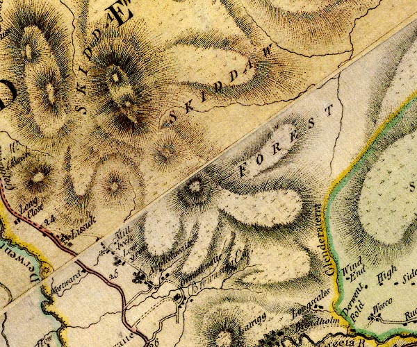 D4NY22NE.jpg "SKIDDAW" hill hachuring; hill or mountain, two summits item:- Carlisle Library : Map 2 Image © Carlisle Library |
|||||||||||||||||||||||||||||||||||||||||||||||||||||||||||||||||||||||||||||||||||||||||
|
|
||||||||||||||||||||||||||||||||||||||||||||||||||||||||||||||||||||||||||||||||||||||||||
| evidence:- | old print:- Middiman 1784-92 placename:- Skiddaw |
|||||||||||||||||||||||||||||||||||||||||||||||||||||||||||||||||||||||||||||||||||||||||
| source data:- | Print, uncoloured engraving, View near Skiddaw, Cumberland, drawn by C Powell, engraved
and published by Samuel Middiman, 3 Grafton Street, Tottenham Court Road, London,
1785. click to enlarge click to enlargeMM0504.jpg "Drawn by C. Powell. / Engrav'd by S. Middiman. / VIEW near SKIDDAW. / Publish'd as the Act directs, Novr. 25. 1785, by S. Middiman, London." Accompanying text:- "PLATE XX." "VIEW near SKIDDAW," "CUMBERLAND." "FROM the great Elevation above Keswick Lake, and vast Circumference of its base, Skiddaw may not improperly be called the AEtna of the North; the perpendicular Height, above the Level of the Sea, is said to be about two thousand Yards. This Mountain rises in the grandest Style, and, viewed from Derwentwater, makes a principal Object in the Scene, bounding all the northern Part of the Vale of Keswick. Several beautiful Seats and pastoral Cots are scattered round its Borders; the most conspicuous are Dr. Brownrigg's Villa at Ormathwaite, and the Vicarage House. From the latter Station, which is seen in the View, Mr. Gray in one of his Evening Rambles "saw in his Glass a Picture, which, could he have fixed in all the Softness of its living Colours, would have fairly sold for a thousand Pounds."" "Skiddaw is clothed with Verdure, extending from the Foot of the Mountain almost to the Summit, which is a barren Plain covered with loose Slate: Near the Top is a small Lake, from which a large Stream falls down, called Whitewater Dash. On the northern Side, which is rocky and precipitous, rises the River Caldew, and after a Course of many Miles through several beautiful Vales, falls into the Eden below Carlisle." "The Prospect that every Way presents itself from this Mountain in mere Extent is prodigious, which, added to the varied Appearance of Hills, Dales, and Lakes, at an awful Distance, form a most grand Picture." item:- Armitt Library : A6862.4 Image © see bottom of page |
|||||||||||||||||||||||||||||||||||||||||||||||||||||||||||||||||||||||||||||||||||||||||
|
|
||||||||||||||||||||||||||||||||||||||||||||||||||||||||||||||||||||||||||||||||||||||||||
| evidence:- | old text:- Clarke 1787 placename:- Skiddow |
|||||||||||||||||||||||||||||||||||||||||||||||||||||||||||||||||||||||||||||||||||||||||
| source data:- | Guide book, A Survey of the Lakes of Cumberland, Westmorland,
and Lancashire, written and published by James Clarke, Penrith,
Cumberland, and in London etc, 1787; published 1787-93. goto source Page 99:- "..." "Nothing now remains, but to account for the silence of Mr Gray concerning this beautiful spot, which is easily done. When Mr Gray was at Keswick, he was desirous of seeing the back of Skiddow, and accordingly took chaise to Ouzebridge, thinking to have a view of the precipices by the way. Timidity, however, prevailed over curiosity, so far, that he no sooner came within sight of those awful rocks than he put up the blinds of his carriage: In this dark situation, trembling every moment lest the mountains should "fall and cover him," he travelled to Ouzebridge: he thus avoided see-" goto sourcePage 100:- "[see]ing, not only the horrors, but the beauties of the place; and therefore, (more honestly than most of our authors,) gives no description of what he never saw. It is indeed a question whether, if Mr Gray had wrote the history of his terrors, it would not have been as entertaining, at least as curious, as his journal. I cannot, however, help thinking, that the world lost more by this unaccountable weakness, than even Mr Gray himself." goto sourcePage 101:- "..." "As most of our travellers would wish to see the top of Skiddow, it now remains to give them directions for reaching it in the easiest manner: We first pass Monk's-Hall, then take the road which crosses the common, and leaving Lath-Rigs on the right, keep under its skirts till we reach the division between it and Skiddow; we then see a little rivulet which falls down at Armathwaite near Dr Brownrigg's house, and then a green path conveys us almost to the top of Skiddow: I say almost, for upon the top nothing is seen but loose stones, and a kind of dry brown moss, and this way a horse can travel. From the top of Skiddow is a most noble prospect, but not so great as some of our Tourists tell us: it is true, we may see the Isle of Man, Solway Frith, and the Scottish hills, but almost every other distant view is blocked up by the surrounding hills. Derwentwater, Newland-Fells, Bassenthwaite-water, Borrowdale, and all the neighbouring hills, except Helveylin, lye like an immense map before you; but Lancaster, Kendal, Milnthorp, and Ulverstone, which, with many other towns, are seen from the top of Helveylin, cannot be seen from the top of Skiddow." |
|||||||||||||||||||||||||||||||||||||||||||||||||||||||||||||||||||||||||||||||||||||||||
|
|
||||||||||||||||||||||||||||||||||||||||||||||||||||||||||||||||||||||||||||||||||||||||||
| evidence:- | old text:- Clarke 1787 placename:- Skiddow placename:- Skiddow Man |
|||||||||||||||||||||||||||||||||||||||||||||||||||||||||||||||||||||||||||||||||||||||||
| source data:- | Guide book, A Survey of the Lakes of Cumberland, Westmorland,
and Lancashire, written and published by James Clarke, Penrith,
Cumberland, and in London etc, 1787; published 1787-93. goto source Page 116:- "... the highest of our northern Alps, Helvellyn." "Cambden speaking of Helvellyn calls it Lauvellin, and says that the country people had a proverb concerning it." ""Skiddow, Lauvellin, and Casticand, Are the highest hills in all England."" ""But the bye-word (as he calls it,) that he was taught when a child, and which continues the same still, is," ""Kidstowpike, Castycam, Helveyllin and Skiddow-man, Are the highest hills ever clumb by Englishmen."" |
|||||||||||||||||||||||||||||||||||||||||||||||||||||||||||||||||||||||||||||||||||||||||
|
|
||||||||||||||||||||||||||||||||||||||||||||||||||||||||||||||||||||||||||||||||||||||||||
| evidence:- | old print:- Clarke 1787 placename:- Skiddow |
|||||||||||||||||||||||||||||||||||||||||||||||||||||||||||||||||||||||||||||||||||||||||
| source data:- | circle click to enlarge click to enlargeCL18.jpg "Skiddow" item:- Armitt Library : A6615.12 Image © see bottom of page |
|||||||||||||||||||||||||||||||||||||||||||||||||||||||||||||||||||||||||||||||||||||||||
|
|
||||||||||||||||||||||||||||||||||||||||||||||||||||||||||||||||||||||||||||||||||||||||||
| evidence:- | old text:- Camden 1789 placename:- Skiddaw item:- Parnassus; Skiddaw, altitude; weather signs; proverb |
|||||||||||||||||||||||||||||||||||||||||||||||||||||||||||||||||||||||||||||||||||||||||
| source data:- | Book, Britannia, or A Chorographical Description of the Flourishing Kingdoms of England,
Scotland, and Ireland, by William Camden, 1586, translated from the 1607 Latin edition
by Richard Gough, published London, 1789. goto source Page 170:- "..." "... Skiddaw the mountain before-mentioned rears its double head so high among the clouds like Parnassus, and looks towards Scruffell, a mountain in Scotland, as if it meant to rival it; by the ascent or descent of the clouds from both which the inhabitants draw presages of the weather, and have this common proverb," "--- If Skiddaw hath a cap Scruffell wots full well of that." "And that other of the height of these and two other mountains in these parts," "Skiddaw, Lawellin, and Casticand Are the highest hills in all England." |
|||||||||||||||||||||||||||||||||||||||||||||||||||||||||||||||||||||||||||||||||||||||||
|
|
||||||||||||||||||||||||||||||||||||||||||||||||||||||||||||||||||||||||||||||||||||||||||
| evidence:- | old text:- Camden 1789 (Gough Additions) placename:- Skiddaw item:- beacon; kistvaen; cranberry; Skiddaw Man |
|||||||||||||||||||||||||||||||||||||||||||||||||||||||||||||||||||||||||||||||||||||||||
| source data:- | Book, Britannia, or A Chorographical Description of the Flourishing Kingdoms of England,
Scotland, and Ireland, by William Camden, 1586, translated from the 1607 Latin edition
by Richard Gough, published London, 1789. goto source Page 182:- "..." "Skiddaw shews its vast base, and bounding all that part of the vale rises gently 1100 yards perpendicular from the broadwater with two heads, with a smooth verdant front, on whose top is Skiddaw maen, a blue slate stone, a beacon or kistvaen. Cranberries grow on it. ..." |
|||||||||||||||||||||||||||||||||||||||||||||||||||||||||||||||||||||||||||||||||||||||||
|
|
||||||||||||||||||||||||||||||||||||||||||||||||||||||||||||||||||||||||||||||||||||||||||
| evidence:- | old print:- Farington 1789 placename:- Skiddaw |
|||||||||||||||||||||||||||||||||||||||||||||||||||||||||||||||||||||||||||||||||||||||||
| source data:- | Print, uncoloured engraving, Derwentwater and Skiddaw, from Brandelow Woods, Cumberland,
drawn by Joseph Farington, engraved by B T Pouncy, published by William Byrne, 79
Titchfield Street, London, 1785.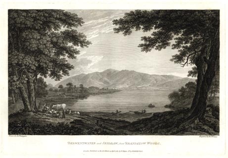 click to enlarge click to enlargeFA0303.jpg printed, bottom left, right, centre "Drawn by Josh. Farington / Engraved by B. T. Pouncy. / DERWENTWATER and SKIDDAW, from BRANDELOW WOODS. / London Published as the Act directs, 15 April 1785, by W. Byrne, No.79, Titchfield Street." item:- Armitt Library : A6668.3 Image © see bottom of page |
|||||||||||||||||||||||||||||||||||||||||||||||||||||||||||||||||||||||||||||||||||||||||
|
|
||||||||||||||||||||||||||||||||||||||||||||||||||||||||||||||||||||||||||||||||||||||||||
| evidence:- | old map:- Aikin 1790 (Cmd) placename:- Skiddaw Hill |
|||||||||||||||||||||||||||||||||||||||||||||||||||||||||||||||||||||||||||||||||||||||||
| source data:- | Map, uncoloured engraving, Cumberland, by John Aikin, London,
1790.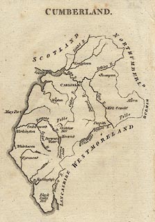 click to enlarge click to enlargeAIK3.jpg "Skiddaw Hill" hillock shaded to east; hill item:- JandMN : 145 Image © see bottom of page |
|||||||||||||||||||||||||||||||||||||||||||||||||||||||||||||||||||||||||||||||||||||||||
|
|
||||||||||||||||||||||||||||||||||||||||||||||||||||||||||||||||||||||||||||||||||||||||||
| evidence:- | old text:- Gents Mag placename:- Skiddow |
|||||||||||||||||||||||||||||||||||||||||||||||||||||||||||||||||||||||||||||||||||||||||
| source data:- | Magazine, The Gentleman's Magazine or Monthly Intelligencer or
Historical Chronicle, published by Edward Cave under the
pseudonym Sylvanus Urban, and by other publishers, London,
monthly from 1731 to 1922. goto source Gentleman's Magazine 1792 p.1116 "..." "We shall end by transcribing some obervations on the summit of Skiddow:" ""When we reach the top, we open the crown of Ingleborough, and the range of hills to the champaign part of Northumberland; we have the Chiviot hills, and the great chain to the point of Mull in Galloway. The sun is setting over Hawthorn island, belonging to Lord Selkirk, partially tinging both coasts. And I cannot omit an opportunity of saying, it is a glorious emblem of an Union that has made Two people One; and, by making our interests the same, has stopped a tide of British blood, and turned our hatred into affection. By carrying the eye to the Mull of Galloway, we just see the North of Ireland, and distinctly the length of the Isle of Man."" |
|||||||||||||||||||||||||||||||||||||||||||||||||||||||||||||||||||||||||||||||||||||||||
|
|
||||||||||||||||||||||||||||||||||||||||||||||||||||||||||||||||||||||||||||||||||||||||||
| evidence:- | old map:- Bailey 1797 placename:- Skiddaw |
|||||||||||||||||||||||||||||||||||||||||||||||||||||||||||||||||||||||||||||||||||||||||
| source data:- | Map, soil etc, uncoloured engraving, Cumberland, scale about 21
miles to 1 inch, by J Bailey, engraved by Neele, Strand,
published by Messrs Robinson, Paternoster Row and G Nicol, Pall
Mall, London, 1797.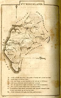 click to enlarge click to enlargeBY04.jpg "Skiddaw" item:- Armitt Library : A680.2 Image © see bottom of page |
|||||||||||||||||||||||||||||||||||||||||||||||||||||||||||||||||||||||||||||||||||||||||
|
|
||||||||||||||||||||||||||||||||||||||||||||||||||||||||||||||||||||||||||||||||||||||||||
| evidence:- | old map:- Cooke 1802 placename:- Skiddow |
|||||||||||||||||||||||||||||||||||||||||||||||||||||||||||||||||||||||||||||||||||||||||
| source data:- | Map, The Lakes, Westmorland and Cumberland, scale about 8.5
miles to 1 inch, engravedby Neele and Son, published by
Sherwood, Jones and Co, Paternoster Road, London, 1824. click to enlarge click to enlargeGRA1Lk.jpg "Skiddow" hillock; mountain item:- Hampshire Museums : FA2000.62.5 Image © see bottom of page |
|||||||||||||||||||||||||||||||||||||||||||||||||||||||||||||||||||||||||||||||||||||||||
|
|
||||||||||||||||||||||||||||||||||||||||||||||||||||||||||||||||||||||||||||||||||||||||||
| evidence:- | old diary:- Green 1802-21 placename:- Skiddaw |
|||||||||||||||||||||||||||||||||||||||||||||||||||||||||||||||||||||||||||||||||||||||||
| source data:- | Diaries kept by William Green, Ambleside, Westmorland, 1802-21. goto source Diary, 23 July 1817:- "23 went up Skiddaw [man] and I had each a horse the party were Miss Sa[mu]ll and Henry M[arsland], Mr C[reser] Mr Orme daughter Sarah Joss and Mr Jonathan Ottly who was our guide the day was charming - and the views [all] the too and at the top very good being as clear as a blue atmosphere [could] probably allow it - just as we were about to return the mist [veiled] the mountain and the views of the aerial country though the [brown] of the [ ]ikly Vapour was peculiarly charming we returned with this sort of weather about two miles & our party was pleasant &we [gained] Keswick in [very] fine weathers the gentlemen [ ] led the two" goto source"Sarahs and myself to dine & Elizabeth came after [dinner] we walked to Brow Top and up the fields to the Castlerigg woods, &down to Water edge Bank - the girls and boys had left us and Orme and I returned to tea at our house, while the others were gone to Lowdore" "..." |
|||||||||||||||||||||||||||||||||||||||||||||||||||||||||||||||||||||||||||||||||||||||||
|
|
||||||||||||||||||||||||||||||||||||||||||||||||||||||||||||||||||||||||||||||||||||||||||
| evidence:- | old text:- Gents Mag item:- geology |
|||||||||||||||||||||||||||||||||||||||||||||||||||||||||||||||||||||||||||||||||||||||||
| source data:- | Magazine, The Gentleman's Magazine or Monthly Intelligencer or
Historical Chronicle, published by Edward Cave under the
pseudonym Sylvanus Urban, and by other publishers, London,
monthly from 1731 to 1922. goto source Gentleman's Magazine 1804 p.847 "..." ""The summit of Skiddaw is covered with a whiteish shivery slate, which threatens to slide down with every gust of wind. The broken state of this slate makes the present summit appear the ruins of others; a circumstance as extraordinary in appearance as difficult to be accounted for. It is impossible for a better description of Skiddaw to be given than this; but who can be so astonished when it is from the pen of the wonderful Mrs. Radcliffe?" (p.58.)" "..." |
|||||||||||||||||||||||||||||||||||||||||||||||||||||||||||||||||||||||||||||||||||||||||
|
|
||||||||||||||||||||||||||||||||||||||||||||||||||||||||||||||||||||||||||||||||||||||||||
| evidence:- | old print:- Green 1804 (plate 18) placename:- Skiddaw |
|||||||||||||||||||||||||||||||||||||||||||||||||||||||||||||||||||||||||||||||||||||||||
| source data:- | Print, uncoloured aquatint, Skiddaw, taken from Castle Crag, near Keswick, Cumberland,
by William Green, Ambleside, Westmorland, 1804.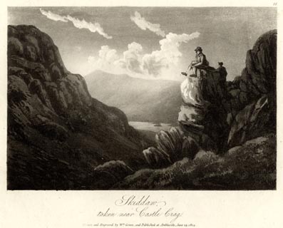 click to enlarge click to enlargeGN1618.jpg Plate 18 from a series. printed at bottom:- "Skiddaw, / taken from Castle Crag. / Drawn and Engraved by Wm. Green, and Published at Ambleside, June 24, 1804." printed at top right:- "18" item:- Armitt Library : 2014.164 Image © see bottom of page |
|||||||||||||||||||||||||||||||||||||||||||||||||||||||||||||||||||||||||||||||||||||||||
|
|
||||||||||||||||||||||||||||||||||||||||||||||||||||||||||||||||||||||||||||||||||||||||||
| evidence:- | old text:- Gents Mag |
|||||||||||||||||||||||||||||||||||||||||||||||||||||||||||||||||||||||||||||||||||||||||
| source data:- | Magazine, The Gentleman's Magazine or Monthly Intelligencer or
Historical Chronicle, published by Edward Cave under the
pseudonym Sylvanus Urban, and by other publishers, London,
monthly from 1731 to 1922. goto source Gentleman's Magazine 1805 p.1123 "... gazed upon the empurpled majesty of Skiddaw. Its insular situation and enormous size afford a striking contrast to the line of rocks girdling the distant shore, which seem shrinking from the perils of competition. Its dun sides, outstretched to a tremendous extent, are broken by frequent gills and excavations; clouds skirt its awful summit; and its stupendous base is blended, by many wavy and fantastic lines, into the smooth level by the subjacent plain." |
|||||||||||||||||||||||||||||||||||||||||||||||||||||||||||||||||||||||||||||||||||||||||
|
|
||||||||||||||||||||||||||||||||||||||||||||||||||||||||||||||||||||||||||||||||||||||||||
| evidence:- | old text:- Gents Mag item:- placename, Skiddaw; clouds |
|||||||||||||||||||||||||||||||||||||||||||||||||||||||||||||||||||||||||||||||||||||||||
| source data:- | Magazine, The Gentleman's Magazine or Monthly Intelligencer or
Historical Chronicle, published by Edward Cave under the
pseudonym Sylvanus Urban, and by other publishers, London,
monthly from 1731 to 1922. goto source Gentleman's Magazine 1805 p.1012 "... Skiddaw probably owes its origin to the Greek word |
|||||||||||||||||||||||||||||||||||||||||||||||||||||||||||||||||||||||||||||||||||||||||
|
|
||||||||||||||||||||||||||||||||||||||||||||||||||||||||||||||||||||||||||||||||||||||||||
| evidence:- | old text:- Gents Mag item:- altitude, Skiddaw |
|||||||||||||||||||||||||||||||||||||||||||||||||||||||||||||||||||||||||||||||||||||||||
| source data:- | Magazine, The Gentleman's Magazine or Monthly Intelligencer or
Historical Chronicle, published by Edward Cave under the
pseudonym Sylvanus Urban, and by other publishers, London,
monthly from 1731 to 1922. goto source Gentleman's Magazine 1805 p.1011 "... On the right of the road Helvellyn lifts its awful form, a mountain of tremendous grandeur, upon whose brow the snow hangs as upon a glacier. The cottagers, nestling at its base, pride themselves in the shelter of this impenetrable rampire, and stoutly repel the imputation of the Keswick peasantry, who assert the greater altitude of their native Skiddaw. ..." |
|||||||||||||||||||||||||||||||||||||||||||||||||||||||||||||||||||||||||||||||||||||||||
|
|
||||||||||||||||||||||||||||||||||||||||||||||||||||||||||||||||||||||||||||||||||||||||||
| evidence:- | old text:- Capper 1808 placename:- Skiddaw |
|||||||||||||||||||||||||||||||||||||||||||||||||||||||||||||||||||||||||||||||||||||||||
| source data:- | Gazetteer, A Topographical Dictionary of the United Kingdom,
compiled by Benjamin Pitts Capper, published by Richard
Phillips, Bridge Street, Blackfriars, London, 1808; published
1808-29. goto source "[Keswick] ... on the north stands Skiddaw, rising more than a 1000 yards perpendicular above the level of the lake; the haunt of numerous birds of prey. Notwithstanding its height, it is not difficult to ascend. At the top the atmosphere is so cold as to prevent vegetation, and the mountain is covered with a loose brown slaty stone. ..." |
|||||||||||||||||||||||||||||||||||||||||||||||||||||||||||||||||||||||||||||||||||||||||
|
|
||||||||||||||||||||||||||||||||||||||||||||||||||||||||||||||||||||||||||||||||||||||||||
| evidence:- | old map:- Cooper 1808 placename:- Skiddaw |
|||||||||||||||||||||||||||||||||||||||||||||||||||||||||||||||||||||||||||||||||||||||||
| source data:- | Map, uncoloured engraving, Cumberland, scale about 10.5 miles to
1 inch, drawn and engraved by Cooper, published by R Phillips,
Bridge Street, Blackfriars, London, 1808. click to enlarge click to enlargeCOP3.jpg "Skiddaw" hill hachuring; mountain or hill item:- JandMN : 86 Image © see bottom of page |
|||||||||||||||||||||||||||||||||||||||||||||||||||||||||||||||||||||||||||||||||||||||||
|
|
||||||||||||||||||||||||||||||||||||||||||||||||||||||||||||||||||||||||||||||||||||||||||
| evidence:- | old print:- Green 1810 (plate 35) placename:- Skiddaw |
|||||||||||||||||||||||||||||||||||||||||||||||||||||||||||||||||||||||||||||||||||||||||
| source data:- | Print, soft ground etching, Skiddaw taken near Lowdore, Borrowdale, Cumberland, by
William Green, Ambleside, Westmorland, 1810.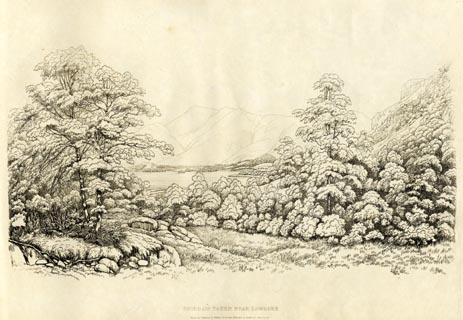 click to enlarge click to enlargeGN1235.jpg Plate 35 in Sixty Studies from Nature, 1810. printed at bottom:- "SKIDDAW TAKEN NEAR LOWDORE. / Drawn and Engraved by William Green, and Published at Ambleside, June 24, 1810." watermark:- "J WHATMAN / 1813" item:- Armitt Library : A6641.35 Image © see bottom of page |
|||||||||||||||||||||||||||||||||||||||||||||||||||||||||||||||||||||||||||||||||||||||||
|
|
||||||||||||||||||||||||||||||||||||||||||||||||||||||||||||||||||||||||||||||||||||||||||
| evidence:- | old print:- Wilkinson 1810 (plate 23) placename:- Skiddaw |
|||||||||||||||||||||||||||||||||||||||||||||||||||||||||||||||||||||||||||||||||||||||||
| source data:- | Print, uncoloured soft ground etching, Part of Skiddaw, from Applethwaite Gill, Cumberland,
by Joseph Wilkinson, engraved by William Frederick Wells, published by R Ackermann,
Repository of Arts, 101 Strand, London, 1810.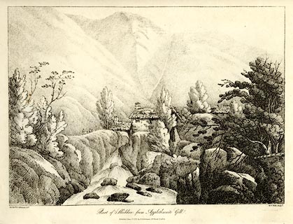 click to enlarge click to enlargeWKN123.jpg Plate 23 in Select Views in Cumberland, Westmoreland, and Lancashire. printed at bottom left, right, centre:- "The Revd. Jos: Wilkenson delt. / W. F. Wells sculpt. / Part of Skiddaw, from Applethwaite Gill. / Published June 1. 1810. by R. Ackermann. 101. Strand. London." item:- Fell and Rock Climbing Club : MN4.23 Image © see bottom of page |
|||||||||||||||||||||||||||||||||||||||||||||||||||||||||||||||||||||||||||||||||||||||||
|
|
||||||||||||||||||||||||||||||||||||||||||||||||||||||||||||||||||||||||||||||||||||||||||
| evidence:- | old text:- Green 1814 placename:- Skiddaw |
|||||||||||||||||||||||||||||||||||||||||||||||||||||||||||||||||||||||||||||||||||||||||
| source data:- | Set of prints, soft ground etchings, Sixty Small Prints, with
text, A Description of a Series of Sixty Small Prints, by
William Green, Ambleside, Westmorland, 1814. goto source page 16:- "..." "The top of Skiddaw in a straight line from Derwent Water is between three and four miles. Skiddaw at a dis-" goto sourcepage 17:- "[dis]tance appears smooth and verdant; and several variously-elevated eminences, being all united by Hogarthian curves, give it an easy, elegant and uncommon appearance, as seen from every part of the valley." "Skiddaw has been called a generous Lord, and the Fells of Borrowdale frowning and haughty Tyrants. Are frowning and haughty tyrants to be preferred to generous lords? Man in his feelings towards man has now pretty well made up his mind on that head; but in his choice of mountains probably he may like the tyrant best." |
|||||||||||||||||||||||||||||||||||||||||||||||||||||||||||||||||||||||||||||||||||||||||
|
|
||||||||||||||||||||||||||||||||||||||||||||||||||||||||||||||||||||||||||||||||||||||||||
| evidence:- | old print with text:- Farington 1816 placename:- Skiddaw item:- altitude, Skiddaw |
|||||||||||||||||||||||||||||||||||||||||||||||||||||||||||||||||||||||||||||||||||||||||
| source data:- | Print, uncoloured engraving and descriptive text, Skiddaw and Derwentwater from Lowdore
Waterfall, Borrowdale, Cumberland, drawn by Joseph Farington, engraved by J Scott,
published by T Cadell and W Davies, Strand, London, 1815.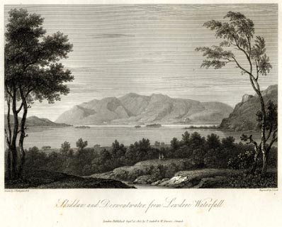 click to enlarge click to enlargeFA0415.jpg printed, bottom left, right, centre "Drawn by J. Farington R.A. / Engraved by J. Scott. / Skiddaw and Derwentwater from Lowdore Waterfall. / London Published Septr. 15, 1815, by T. Cadell &W. Davies, Strand." Descriptive text:- "SKIDDAW AND DERWENTWATER, FROM LOWDORE WATERFALL." "THIS plate offers a view of the mountain of Skiddaw, and the lake of Keswick, or Derwentwater, as seen from the cataract of Lowdore. Skiddaw is one of the highest mountains in England, being upwards of 3300 feet above the level of the sea: it is about two mile distant from Keswick, from which place tourists usually commence their ascent to its summit; which may be done on horseback without much difficulty by those, to whom it would be too great an exertion to attempt its accomplishment on foot. The surface of this mountain is in general smooth and verdant: and on its summit is a long and broad bed of large, loose pieces of slate. The view from this spot, on a clear day, is grand and extensive indeed; reaching northward to the Scottish hills, eastward to the German Ocean, and westward to the Irish Channel." "..." item:- Armitt Library : A6666.15 Image © see bottom of page |
|||||||||||||||||||||||||||||||||||||||||||||||||||||||||||||||||||||||||||||||||||||||||
|
|
||||||||||||||||||||||||||||||||||||||||||||||||||||||||||||||||||||||||||||||||||||||||||
| evidence:- | old print with text:- Farington 1816 placename:- Skiddaw |
|||||||||||||||||||||||||||||||||||||||||||||||||||||||||||||||||||||||||||||||||||||||||
| source data:- | Print, uncoloured engraving and descriptive text, Keswick and Skiddaw, Cumberland,
drawn by Joseph Farington, engraved by J Byrne, published by T Cadell and W Davies,
Strand, London, 1815.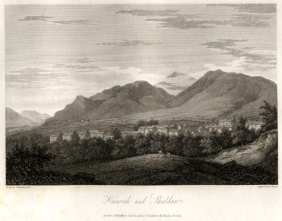 click to enlarge click to enlargeFA0427.jpg printed, bottom left, right, centre "Drawn by J. Farington R.A. / Engraved by J. Byrne. / Keswick and Skiddaw. / London Published Septr. 15, 1815, by T. Cadell &W. Davies, Strand." Descriptive text:- "KESWICK AND SKIDDAW." "KESWICK ... Behind the town rises the dark-frowning Skiddaw (already described) in rugged majesty. ..." item:- Armitt Library : A6666.27 Image © see bottom of page |
|||||||||||||||||||||||||||||||||||||||||||||||||||||||||||||||||||||||||||||||||||||||||
|
|
||||||||||||||||||||||||||||||||||||||||||||||||||||||||||||||||||||||||||||||||||||||||||
| evidence:- | old map:- Otley 1818 placename:- Skiddaw |
|||||||||||||||||||||||||||||||||||||||||||||||||||||||||||||||||||||||||||||||||||||||||
| source data:- | Map, uncoloured engraving, The District of the Lakes,
Cumberland, Westmorland, and Lancashire, scale about 4 miles to
1 inch, by Jonathan Otley, 1818, engraved by J and G Menzies,
Edinburgh, Scotland, published by Jonathan Otley, Keswick,
Cumberland, et al, 1833. OT02NY22.jpg "SKIDDAW" item:- JandMN : 48.1 Image © see bottom of page |
|||||||||||||||||||||||||||||||||||||||||||||||||||||||||||||||||||||||||||||||||||||||||
|
|
||||||||||||||||||||||||||||||||||||||||||||||||||||||||||||||||||||||||||||||||||||||||||
| evidence:- | old print:- Westall 1820 |
|||||||||||||||||||||||||||||||||||||||||||||||||||||||||||||||||||||||||||||||||||||||||
| source data:- | Print, uncoloured mezzotint, Portinscale Bridge, near Keswick, Cumberland, drawn and
engraved by William Westall, published by Rodwell and Martin, New Bond Street, London,
1820.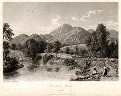 click to enlarge click to enlargeWTL110.jpg printed, bottom left, centre "Drawn & Engraved by W. Westall A.R.A. / Portinscale Bridge, / near Keswick. / Published July 1, 1819, by Hurst, Robinson &Co. Cheapside." item:- Armitt Library : A6671.10 Image © see bottom of page |
|||||||||||||||||||||||||||||||||||||||||||||||||||||||||||||||||||||||||||||||||||||||||
|
|
||||||||||||||||||||||||||||||||||||||||||||||||||||||||||||||||||||||||||||||||||||||||||
| evidence:- | old print:- Westall 1820 placename:- Skiddaw |
|||||||||||||||||||||||||||||||||||||||||||||||||||||||||||||||||||||||||||||||||||||||||
| source data:- | Print, uncoloured mezzotint, Skiddaw, Cumberland, drawn and engraved by William Westall,
published by Rodwell and Martin, New Bond Street, London, 1820. click to enlarge click to enlargeWTL112.jpg printed, bottom left, centre "Drawn & Engraved by W. Westall A.R.A. / Skiddaw. / Published June 1, 1820, by Hurst, Robinson &Co. Cheapside." item:- Armitt Library : A6671.12 Image © see bottom of page |
|||||||||||||||||||||||||||||||||||||||||||||||||||||||||||||||||||||||||||||||||||||||||
|
|
||||||||||||||||||||||||||||||||||||||||||||||||||||||||||||||||||||||||||||||||||||||||||
| evidence:- | old print:- Fielding and Walton 1821 (plate 38) placename:- Skiddaw |
|||||||||||||||||||||||||||||||||||||||||||||||||||||||||||||||||||||||||||||||||||||||||
| source data:- | Print, coloured aquatint, Skiddaw, from the Head of Lowdore Fall, Borrowdale, Cumberland,
drawn by John Walton, published by R Ackermann, 101 Strand, London, 1821. click to enlarge click to enlargeFW0138.jpg Tipped in opposite p.248 in A Picturesque Tour of the English Lakes. item:- Dove Cottage : 1993.R566.38 Image © see bottom of page |
|||||||||||||||||||||||||||||||||||||||||||||||||||||||||||||||||||||||||||||||||||||||||
|
|
||||||||||||||||||||||||||||||||||||||||||||||||||||||||||||||||||||||||||||||||||||||||||
| evidence:- | outline view:- Otley 1823 (4th edn 1830) placename:- Skiddaw Man |
|||||||||||||||||||||||||||||||||||||||||||||||||||||||||||||||||||||||||||||||||||||||||
| source data:- | Print, engraving, Outline View of Skiddaw, and Saddleback, as seen on approaching
Keswick from the South, published by Jonathan Otley, Keswick, Cumberland et al, 1830.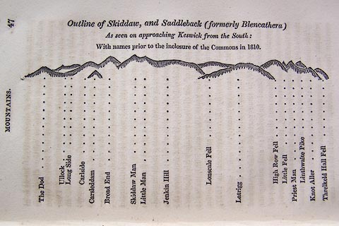 click to enlarge click to enlargeO75E01.jpg p.47 in A Concise Description of the English Lakes, by Jonathan Otley, 4th edition, 1830. "Outline View of Skiddaw, and Saddleback (formerly Blencathera) As seen on approaching Keswick from the South: With names prior to the inclosure of the Commons in 1810." "The Dod / Ullock / Long Side / Carleside / Carsleddam / Broad End / Skiddaw Man / Little Man / Jenkin Hill / Lonscale Fell / Latrigg / High Row Fell / Little Fell / Priest Man / Linthwaite Pike / Knot Aller / Threlkeld Hall Fell" item:- Armitt Library : A1175.2 Image © see bottom of page |
|||||||||||||||||||||||||||||||||||||||||||||||||||||||||||||||||||||||||||||||||||||||||
|
|
||||||||||||||||||||||||||||||||||||||||||||||||||||||||||||||||||||||||||||||||||||||||||
| evidence:- | old text:- Otley 1823 (5th edn 1834) item:- bearings |
|||||||||||||||||||||||||||||||||||||||||||||||||||||||||||||||||||||||||||||||||||||||||
| source data:- | Guide book, A Concise Description of the English Lakes, the
mountains in their vicinity, and the roads by which they may be
visited, with remarks on the mineralogy and geology of the
district, by Jonathan Otley, published by the author, Keswick,
Cumberland now Cumbria, by J Richardson, London, and by Arthur
Foster, Kirkby Lonsdale, Cumbria, 1823; published 1823-49,
latterly as the Descriptive Guide to the English Lakes. goto source Page 78:- "STATION II.- SKIDDAW." Latitude 54° 39′ 12″ N. Longitude 3° 8′ 9″W. Height 3022 feet.
|
|||||||||||||||||||||||||||||||||||||||||||||||||||||||||||||||||||||||||||||||||||||||||
|
|
||||||||||||||||||||||||||||||||||||||||||||||||||||||||||||||||||||||||||||||||||||||||||
| evidence:- | outline view:- Otley 1823 (8th edn 1849) placename:- Skiddaw placename:- Skiddaw Man |
|||||||||||||||||||||||||||||||||||||||||||||||||||||||||||||||||||||||||||||||||||||||||
| source data:- | Engraving, outline view of mountains, Grasmere from Red Bank Head, drawn by T Binns,
engraved by O Jewitt, opposite p.4 of A Descriptive Guide of the English Lakes, by
Jonathan Otley, 8th edition, 1849.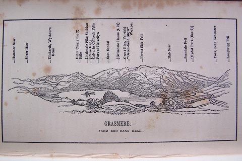 click to enlarge click to enlargeO80E04.jpg item:- Armitt Library : A1180.5 Image © see bottom of page |
|||||||||||||||||||||||||||||||||||||||||||||||||||||||||||||||||||||||||||||||||||||||||
|
|
||||||||||||||||||||||||||||||||||||||||||||||||||||||||||||||||||||||||||||||||||||||||||
| evidence:- | outline view:- Otley 1823 (8th edn 1849) placename:- Skiddaw placename:- Skiddaw Man |
|||||||||||||||||||||||||||||||||||||||||||||||||||||||||||||||||||||||||||||||||||||||||
| source data:- | Engraving, outline view of mountains, Skiddaw, and Saddleback ... as seen on entering
Keswick from the South, drawn by T Binns, engraved by O Jewitt, opposite p.46 of A
Descriptive Guide of the English Lakes, by Jonathan Otley, 8th edition, 1849.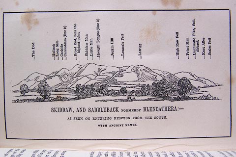 click to enlarge click to enlargeO80E16.jpg item:- Armitt Library : A1180.17 Image © see bottom of page |
|||||||||||||||||||||||||||||||||||||||||||||||||||||||||||||||||||||||||||||||||||||||||
|
|
||||||||||||||||||||||||||||||||||||||||||||||||||||||||||||||||||||||||||||||||||||||||||
| evidence:- | old print:- Westall 1830s placename:- Skiddaw |
|||||||||||||||||||||||||||||||||||||||||||||||||||||||||||||||||||||||||||||||||||||||||
| source data:- | Print, aquatint panorama, The Vale of Keswick, from the Ambleside Road, Cumberland,
drawn and engraved by William Westall, published by Ackermann and Co, 96 Strand, London,
1836.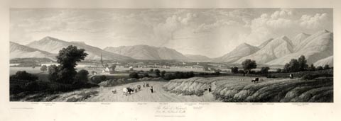 click to enlarge click to enlargeWTL312.jpg "Swinside. Grisedale Pike. 2680 feet. Keswick Lake. Whinlatter. Kings Seat. The Barfe. Bassenthwaite Lake. Greata Hall. Mr. Southey's. Wilhop brows. Skiddaw Dod. Applethwaite. Carlside. Summit of Skiddaw. 3022ft. / Drawn & Engraved by W. Westall A.R.A. / The Vale of Keswick, from the Ambleside road. / Published by Ackermann and Co, 96 Strand. 1836." item:- Armitt Library : A6658.12 Image © see bottom of page |
|||||||||||||||||||||||||||||||||||||||||||||||||||||||||||||||||||||||||||||||||||||||||
|
|
||||||||||||||||||||||||||||||||||||||||||||||||||||||||||||||||||||||||||||||||||||||||||
| evidence:- | old print:- Westall 1830s placename:- Skiddaw |
|||||||||||||||||||||||||||||||||||||||||||||||||||||||||||||||||||||||||||||||||||||||||
| source data:- | Print, aquatint panorama, Keswick Lake, from the West Side, near Water End, Cumberland,
drawn and engraved by William Westall, published by Ackermann and Co, 96 Strand, London,
1833.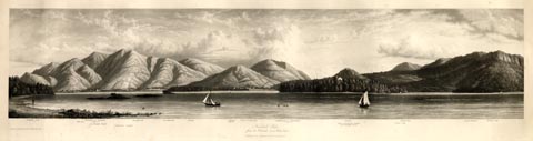 click to enlarge click to enlargeWTL315.jpg "Skiddaw Dod Mill beck Summit of Skiddaw, 3022ft. Crosthwaite Church Lingholm's Islands Applethwaite Ormathwaite Istmus Latrigg 1160ft. Town of Keswick Saddleback or Blencathra 2787ft. Vicar or Derwent Island Genl. Peachey's house. Castlet. Friar's Crag White Pike Lord's island Walla Crag / Drawn & Engraved by W. Westall A.R.A. / Keswick Lake, / from the West side, near Water End. / Published by Ackermann and Co, 96 Strand. 1833." item:- Armitt Library : A6658.15 Image © see bottom of page |
|||||||||||||||||||||||||||||||||||||||||||||||||||||||||||||||||||||||||||||||||||||||||
|
|
||||||||||||||||||||||||||||||||||||||||||||||||||||||||||||||||||||||||||||||||||||||||||
| evidence:- | old print:- Westall 1830s placename:- Skiddaw |
|||||||||||||||||||||||||||||||||||||||||||||||||||||||||||||||||||||||||||||||||||||||||
| source data:- | Print, aquatint panorama, Bassenthwaite Lake, from the Keswick Road, near the 6 Mile
Stone, Cumberland, drawn and engraved by William Westall, published by Ackermann and
Co, 96 Strand, London, 1835.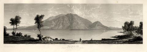 click to enlarge click to enlargeWTL316.jpg "Caldbeck. Westfell. Dead crags. Bassenthwaite high side. Summit of Skiddaw. Ullock. Carlside. Skiddaw dod. Great dod. Helvellen. Walla crag. Catbell. / Drawn & Engraved by W. Westall A.R.A. / Bassenthwaite Lake, from the Keswick Road, near the 6 mile stone. / Published by Ackermann and Co, 96 Strand. 1835." item:- Armitt Library : A6658.16 Image © see bottom of page |
|||||||||||||||||||||||||||||||||||||||||||||||||||||||||||||||||||||||||||||||||||||||||
|
|
||||||||||||||||||||||||||||||||||||||||||||||||||||||||||||||||||||||||||||||||||||||||||
| evidence:- | descriptive text:- Ford 1839 (3rd edn 1843) placename:- Skiddaw item:- altitude, Skiddaw |
|||||||||||||||||||||||||||||||||||||||||||||||||||||||||||||||||||||||||||||||||||||||||
| source data:- | Guide book, A Description of Scenery in the Lake District, by
Rev William Ford, published by Charles Thurnam, Carlisle, by W
Edwards, 12 Ave Maria Lane, Charles Tilt, Fleet Street, William
Smith, 113 Fleet Street, London, by Currie and Bowman,
Newcastle, by Bancks and Co, Manchester, by Oliver and Boyd,
Edinburgh, and by Sinclair, Dumfries, 1839. goto source "... THE Lake district ... consists of large masses or clusters of mountains, generally terminating in one aspiring and pre-eminent point, with the intermediate valleys occupied either by lakes and their subsidiary tarns, or by winding rivers." "The chief nuclei of these clusters are, Skiddaw and Blencathra, Helvellyn, Fairfield, Coniston Old Man, Blackcomb, Scafell, Gable, Red Pike, Grasmoor, Grisdale Pike, and the Langdale Pikes. Many noble and commanding mountains rise around these, rivalling them in height and grandeur, but still" goto sourcePage iv:- "serving as large buttresses only. In the presentation of endlessly-diversified forms, these Mountains yield to none, however individually inferior they may be, owing to their being seldom seen in a detached point of view; although, on the other hand, they have thus the advantage of forming combinations at once grand and sublime, towering above each other, or rising in ridges, like the mighty billows of the ocean." goto sourcePage 63:- "..." "SKIDDAW" "Is less difficult of ascent than the rest of the superior elevations, and the road from the town is so conducted as to render the way easy either on foot or on horseback. The views in the ascent are perhaps superior to those presented from the summit. One of the finest is where Ormathwaite appears splendidly surrounded by majestic trees, and all the populous and beautifully-embowered plain extending from lake to lake. A little further is an exquisite view of Keswick and the lake, with" goto sourcePage 64:- "the Borrowdale, Langdale, and Wastdale mountains. On the steepest part of the road, Derwent Water gradually unfolds and extends itself in its whole encircling and beautifully-embayed coast, its islands, and its fertile shores and savage boundaries. Hence also the high mountains of Langdale, Coniston, Eskdale, Borrowdale, Wastdale, Buttermere, and Newlands, are observed in an arrangement superior to their appearance from any other point. There are seven distinct tops or heaps of stone, which should be visited in succession by the pedestrian: most of these present interesting and varying views, but the chief elevation is deficient in not allowing a sight of Derwent Water. The grand and extensive prospects embrace five different ranges of mountains: First, Grizedale, rising from the enclosures of Braithwaite. Second, succeeded by Barrow and Stile End. The third range rises from the fields of Newlands, and terminates in Causey Pikes and Grasmire. The fourth in this wild combination, includes Cat Bells, Hindscarth, Robinson, and Red Pike. The fifth and last, is that sublime chain extending from Coniston to Ennerdale. In the distant sea is observable the Isle of Man; the towns of Cockermouth and Workington on the Derwent; the Solway, with Maryport and Allonby; Ireby at the foot of Binsey; Wigton and Carlisle; High Hesket and Tarn Wadling; and Blencathra and Wanthwaite Crags." "The descent will appear to many more pleasing, both as it is easier, and as it is agreeable to see" goto sourcePage 65:- "every thing resuming their original shapes and just proportions, which they lose when viewed from such an unusual elevation. The returning symptoms of life, the hum of bees, the song of birds, and the voice of busy people, restore tone to the spirits depressed by over much excitement." goto sourcePage 85:- "... a view of the lake [Bassenthwaite], with the lordly Skiddaw looming over it, his head most probably graced with a tiara of clouds. ..." goto sourcePage 178:- "ELEVATION OF THE MOUNTAINS," "ACCORDING TO DIFFERENT AUTHORITIES."
|
|||||||||||||||||||||||||||||||||||||||||||||||||||||||||||||||||||||||||||||||||||||||||
|
|
||||||||||||||||||||||||||||||||||||||||||||||||||||||||||||||||||||||||||||||||||||||||||
| evidence:- | old map:- Ford 1839 map placename:- Skiddaw |
|||||||||||||||||||||||||||||||||||||||||||||||||||||||||||||||||||||||||||||||||||||||||
| source data:- | Map, uncoloured engraving, Map of the Lake District of
Cumberland, Westmoreland and Lancashire, scale about 3.5 miles
to 1 inch, published by Charles Thurnam, Carlisle, and by R
Groombridge, 5 Paternoster Row, London, 3rd edn 1843. FD02NY23.jpg "Skiddaw" Hill hachuring. item:- JandMN : 100.1 Image © see bottom of page |
|||||||||||||||||||||||||||||||||||||||||||||||||||||||||||||||||||||||||||||||||||||||||
|
|
||||||||||||||||||||||||||||||||||||||||||||||||||||||||||||||||||||||||||||||||||||||||||
| evidence:- | old map:- Garnett 1850s-60s H placename:- Skiddaw |
|||||||||||||||||||||||||||||||||||||||||||||||||||||||||||||||||||||||||||||||||||||||||
| source data:- | Map of the English Lakes, in Cumberland, Westmorland and
Lancashire, scale about 3.5 miles to 1 inch, published by John
Garnett, Windermere, Westmorland, 1850s-60s. GAR2NY22.jpg "Skiddaw" hill hachuring item:- JandMN : 82.1 Image © see bottom of page |
|||||||||||||||||||||||||||||||||||||||||||||||||||||||||||||||||||||||||||||||||||||||||
|
|
||||||||||||||||||||||||||||||||||||||||||||||||||||||||||||||||||||||||||||||||||||||||||
| evidence:- | old print with text:- Pyne 1853 placename:- Skiddaw |
|||||||||||||||||||||||||||||||||||||||||||||||||||||||||||||||||||||||||||||||||||||||||
| source data:- | Print, tinted lithograph, Skiddaw, Cumberland, by James Baker Pyne, engraved by W
Gauci, published by Thomas Agnew and Sons, Manchester, Lancashire, 1853.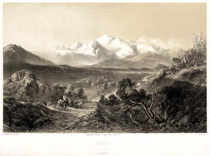 click to enlarge click to enlargePYN206.jpg "PAINTED BY J. B. PYNE. / W. GAUCI LITH. / MANCHESTER, PUBLISHED BY THOMAS AGNEW & SONS, 1853. / Skiddaw / M & N HANHART IMPT." From the descriptive text:- "... The intellectual tourist may study some of the general laws which govern the universe during an ascent of this mountain. A thermometer will exhibit a difference of temperature betwixt the plain and summit of some nine or ten degrees Fahrenheit; and the mercury in a barometer will descend rather more than three inches: that is to say, one-tenth of the whole atmosphere will have been passed through. ... " item:- Armitt Library : A6678.7 Image © see bottom of page |
|||||||||||||||||||||||||||||||||||||||||||||||||||||||||||||||||||||||||||||||||||||||||
|
|
||||||||||||||||||||||||||||||||||||||||||||||||||||||||||||||||||||||||||||||||||||||||||
| evidence:- | old print:- Pyne 1853 placename:- Skiddaw |
|||||||||||||||||||||||||||||||||||||||||||||||||||||||||||||||||||||||||||||||||||||||||
| source data:- | Print, coloured lithograph, Skiddaw, Cumberland, by James Baker Pyne, engraved by
W Gauci, published by Thomas Agnew and Sons, Manchester, Lancashire, 1853.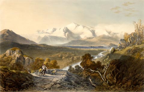 click to enlarge click to enlargePYN406.jpg item:- Armitt Library : A6677.7 Image © see bottom of page |
|||||||||||||||||||||||||||||||||||||||||||||||||||||||||||||||||||||||||||||||||||||||||
|
|
||||||||||||||||||||||||||||||||||||||||||||||||||||||||||||||||||||||||||||||||||||||||||
| evidence:- | old text:- Martineau 1855 item:- altitude, Skiddaw |
|||||||||||||||||||||||||||||||||||||||||||||||||||||||||||||||||||||||||||||||||||||||||
| source data:- | Guide book, A Complete Guide to the English Lakes, by Harriet
Martineau, published by John Garnett, Windermere, Westmorland,
and by Whittaker and Co, London, 1855; published 1855-76. goto source Page 179:- "A TABLE OF THE HEIGHTS OF MOUNTAINS IN THE COUNTIES OF CUMBERLAND, WESTMORLAND, AND LANCASHIRE." "No. : Names of Mountains. : Counties. : Height in Feet above the Sea Level." "4 : Skiddaw : Cumberland : 3022" |
|||||||||||||||||||||||||||||||||||||||||||||||||||||||||||||||||||||||||||||||||||||||||
|
|
||||||||||||||||||||||||||||||||||||||||||||||||||||||||||||||||||||||||||||||||||||||||||
| evidence:- | old text:- Dickens 1857 placename:- Skiddaw |
|||||||||||||||||||||||||||||||||||||||||||||||||||||||||||||||||||||||||||||||||||||||||
| source data:- | Book, The Lazy Tour of Two Idle Apprentices, by Charles Dickens,
1857. goto source Page 8:- "..." "Up hill and down hill, and twisting to the right, and twisting to the left, and with old Skiddaw (who has vaunted himself a great deal more than his merits deserve; but that is rather the way of the Lake country), dodging the apprentices [Thomas Idle and Francis Goodchild] in a picturesque and pleasant manner." |
|||||||||||||||||||||||||||||||||||||||||||||||||||||||||||||||||||||||||||||||||||||||||
|
|
||||||||||||||||||||||||||||||||||||||||||||||||||||||||||||||||||||||||||||||||||||||||||
| evidence:- | old print:- Walton 1876 placename:- Skiddaw |
|||||||||||||||||||||||||||||||||||||||||||||||||||||||||||||||||||||||||||||||||||||||||
| source data:- | Print, colour lithograph, Skiddaw, from the Matterdale Moors, Cumberland, from a painting
by Elijah Walton, published by W M Thompson, 20 Cockspur Street, Pall Mall, and Burlington
Gallery, Piccadilly, London, 1876. click to enlarge click to enlargeWLT313.jpg Plate 13 in English Lake Scenery, with a description by T G Bonney. item:- JandMN : 469.13 Image © see bottom of page |
|||||||||||||||||||||||||||||||||||||||||||||||||||||||||||||||||||||||||||||||||||||||||
|
|
||||||||||||||||||||||||||||||||||||||||||||||||||||||||||||||||||||||||||||||||||||||||||
| evidence:- | old print:- Walton 1876 placename:- Skiddaw |
|||||||||||||||||||||||||||||||||||||||||||||||||||||||||||||||||||||||||||||||||||||||||
| source data:- | Print, colour lithograph, Derwentwater and Skiddaw, Cumberland, from a painting by
Elijah Walton, published by W M Thompson, 20 Cockspur Street, Pall Mall, and Burlington
Gallery, Piccadilly, London, 1876. click to enlarge click to enlargeWLT317.jpg Plate 17 in English Lake Scenery, with a description by T G Bonney. item:- JandMN : 469.17 Image © see bottom of page |
|||||||||||||||||||||||||||||||||||||||||||||||||||||||||||||||||||||||||||||||||||||||||
|
|
||||||||||||||||||||||||||||||||||||||||||||||||||||||||||||||||||||||||||||||||||||||||||
| evidence:- | old photograph:- Bell 1880s-1940s |
|||||||||||||||||||||||||||||||||||||||||||||||||||||||||||||||||||||||||||||||||||||||||
| source data:- | Photograph, sepia, Derwent Water and Skiddaw, Keswick, Cumberland, by Herbert Bell,
Ambleside, Westmorland, 1881. click to enlarge click to enlargeHB0285.jpg item:- Armitt Library : ALPS642 Image © see bottom of page |
|||||||||||||||||||||||||||||||||||||||||||||||||||||||||||||||||||||||||||||||||||||||||
|
|
||||||||||||||||||||||||||||||||||||||||||||||||||||||||||||||||||||||||||||||||||||||||||
| evidence:- | old photograph:- Bell 1880s-1940s |
|||||||||||||||||||||||||||||||||||||||||||||||||||||||||||||||||||||||||||||||||||||||||
| source data:- | Photograph, b/w, Keswick and Skiddaw, Cumberland, by Herbert Bell, Ambleside, Westmorland,
1890s?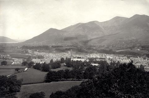 click to enlarge click to enlargeHB0289.jpg item:- Armitt Library : ALPS646 Image © see bottom of page |
|||||||||||||||||||||||||||||||||||||||||||||||||||||||||||||||||||||||||||||||||||||||||
|
|
||||||||||||||||||||||||||||||||||||||||||||||||||||||||||||||||||||||||||||||||||||||||||
| evidence:- | old print:- Bemrose 1881 placename:- Skiddaw |
|||||||||||||||||||||||||||||||||||||||||||||||||||||||||||||||||||||||||||||||||||||||||
| source data:- | Print, uncoloured, Skiddaw, Underskiddaw, Cumberland, published by Bemrose and Sons,
23 Old Bailey, London and Derby, by A B Moss, Carlisle, Cumberland, and by T Wilson,
Kendal, Westmorland, about 1881.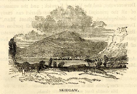 click to enlarge click to enlargeBEM120.jpg On p.73 of a Handy Guide to the English Lakes and Shap Spa. printed at bottom:- "SKIDDAW." item:- JandMN : 455.22 Image © see bottom of page |
|||||||||||||||||||||||||||||||||||||||||||||||||||||||||||||||||||||||||||||||||||||||||
|
|
||||||||||||||||||||||||||||||||||||||||||||||||||||||||||||||||||||||||||||||||||||||||||
| evidence:- | old print:- Bradley 1901 placename:- Skiddaw |
|||||||||||||||||||||||||||||||||||||||||||||||||||||||||||||||||||||||||||||||||||||||||
| source data:- | Print, uncoloured lithograph, Skiddaw, from the Cockermouth Road, Underskiddaw, Cumberland,
by Joseph Pennell, published by Macmillan and Co, London, 1901.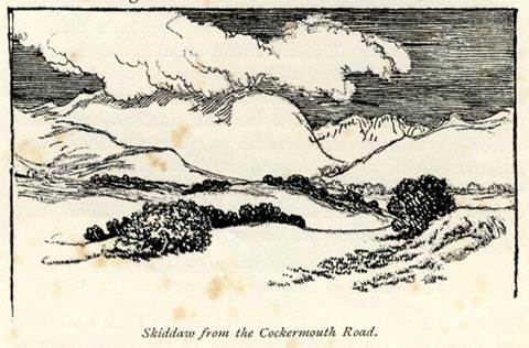 click to enlarge click to enlargeBRL119.jpg On page 98 of Highways and Byways in the Lake District, by A G Bradley. printed at bottom:- "Skiddaw, from the Cockermouth Road." item:- JandMN : 464.19 Image © see bottom of page |
|||||||||||||||||||||||||||||||||||||||||||||||||||||||||||||||||||||||||||||||||||||||||
|
|
||||||||||||||||||||||||||||||||||||||||||||||||||||||||||||||||||||||||||||||||||||||||||
| evidence:- | old print:- Bradley 1901 placename:- Skiddaw |
|||||||||||||||||||||||||||||||||||||||||||||||||||||||||||||||||||||||||||||||||||||||||
| source data:- | Print, uncoloured lithograph, Skiddaw, from the Foot of Bassenthwaite, Underskiddaw,
Cumberland, by Joseph Pennell, published by Macmillan and Co, London, 1901.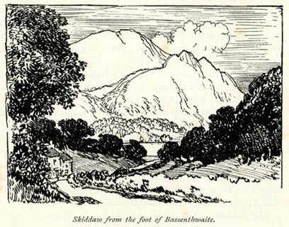 click to enlarge click to enlargeBRL121.jpg On page 103 of Highways and Byways in the Lake District, by A G Bradley. printed at bottom:- "Skiddaw, from the Foot of Bassenthwaite." item:- JandMN : 464.21 Image © see bottom of page |
|||||||||||||||||||||||||||||||||||||||||||||||||||||||||||||||||||||||||||||||||||||||||
|
|
||||||||||||||||||||||||||||||||||||||||||||||||||||||||||||||||||||||||||||||||||||||||||
| evidence:- | old print:- Heaton Cooper 1905 (edn 1908) placename:- Skiddaw |
|||||||||||||||||||||||||||||||||||||||||||||||||||||||||||||||||||||||||||||||||||||||||
| source data:- | Print, colour halftone, Bassenthwaite Lake and Skiddaw, Cumberland, from a watercolour
painting by Alfred Heaton Cooper, published by Adam and Charles Black, London, 2nd
edn 1908.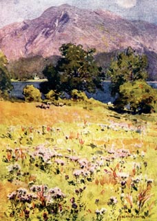 click to enlarge click to enlargeHC0156.jpg Opposite p.162 of The English Lakes, painted by Alfred Heaton Cooper, described by William T Palmer. printed at tissue opposite the print:- "BASSENTHWAITE LAKE AND SKIDDAW" printed at signed lower right:- "[A HEATON COOPER]" item:- JandMN : 468.56 Image © see bottom of page |
|||||||||||||||||||||||||||||||||||||||||||||||||||||||||||||||||||||||||||||||||||||||||
|
|
||||||||||||||||||||||||||||||||||||||||||||||||||||||||||||||||||||||||||||||||||||||||||
| evidence:- | text:- Mason 1907 (edn 1930) |
|||||||||||||||||||||||||||||||||||||||||||||||||||||||||||||||||||||||||||||||||||||||||
| source data:- | Text book, The Ambleside Geography Books bk.III, The Counties of
England, by Charlotte M Mason, published by Kegan Paul, Trench,
Trubner and Co, Broadway House, 68-74 Carter Lane, and the
Parents' Educational Union Office, 26 Victoria Street, London,
edn 1930. MSN1P020.txt Page 20:- "..." "Helvellyn is the monarch of the lake mountains: Sca Fell is a hundred feet higher; Skiddaw, Sca Fell, and Helvellyn are all over 3000 feet; but neither of the others is such a big, swelling, giant of a mountain as Helvellyn." |
|||||||||||||||||||||||||||||||||||||||||||||||||||||||||||||||||||||||||||||||||||||||||
|
|
||||||||||||||||||||||||||||||||||||||||||||||||||||||||||||||||||||||||||||||||||||||||||
| evidence:- | old map:- Postlethwaite 1877 (3rd edn 1913) placename:- Skiddaw |
|||||||||||||||||||||||||||||||||||||||||||||||||||||||||||||||||||||||||||||||||||||||||
| source data:- | Map, uncoloured engraving, Map of the Lake District Mining Field, Westmorland, Cumberland,
Lancashire, scale about 5 miles to 1 inch, by John Postlethwaite, published by W H
Moss and Sons, 13 Lowther Street, Whitehaven, Cumberland, 1877 edn 1913. PST2NY22.jpg "Skiddaw" hill hachuring item:- JandMN : 162.2 Image © see bottom of page |
|||||||||||||||||||||||||||||||||||||||||||||||||||||||||||||||||||||||||||||||||||||||||
|
|
||||||||||||||||||||||||||||||||||||||||||||||||||||||||||||||||||||||||||||||||||||||||||
| evidence:- | old map:- Burrow 1920s |
|||||||||||||||||||||||||||||||||||||||||||||||||||||||||||||||||||||||||||||||||||||||||
| source data:- | Road book, On the Road, Dunlop Pictorial Road Plans, volume V,
strip maps with parts in Westmorland, Cumberland etc, irregular
scale about 1.5 miles to 1 inch, by E J Burrow and Co,
Cheltenham, Gloucestershire, 1920s. EJB3Vg45.jpg item:- private collection : 17 Image © see bottom of page |
|||||||||||||||||||||||||||||||||||||||||||||||||||||||||||||||||||||||||||||||||||||||||
|
|
||||||||||||||||||||||||||||||||||||||||||||||||||||||||||||||||||||||||||||||||||||||||||
| evidence:- | old postcard:- placename:- Skiddaw |
|||||||||||||||||||||||||||||||||||||||||||||||||||||||||||||||||||||||||||||||||||||||||
| source data:- | Postcard, colour photogravure, Derwentwater and Skiddaw from Ashness Bridge, by G
P Abrahams, Keswick, Cumberland, purchased about 1954.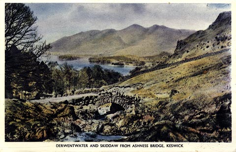 click to enlarge click to enlargePH0060.jpg printed at reverse:- "Photogravure Series by G. P. ABRAHAM, LTD. (Copyright) KESWICK" item:- JandMN : 342 Image © see bottom of page |
|||||||||||||||||||||||||||||||||||||||||||||||||||||||||||||||||||||||||||||||||||||||||
|
|
||||||||||||||||||||||||||||||||||||||||||||||||||||||||||||||||||||||||||||||||||||||||||
| evidence:- | outline view:- Matthew 1866 placename:- Skiddow Man |
|||||||||||||||||||||||||||||||||||||||||||||||||||||||||||||||||||||||||||||||||||||||||
| source data:- | Print, engraving, outline view, View from Watendlath Road of Derwent Water and Bassenthwaite,
Cumberland, published by J Richardson, Highgate, Kendal, Westmorland, 1866.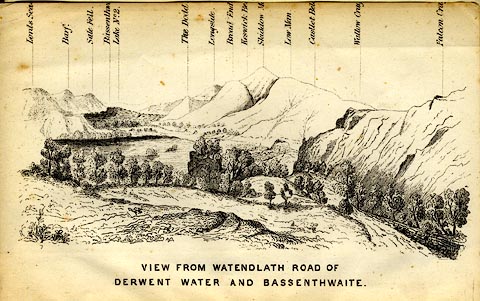 click to enlarge click to enlargeMW1E05.jpg Tipped in before p.1 of The English Lakes, Peaks and Passes, from Kendal to Keswick, by George King Matthew. printed at bottom:- "VIEW FROM WATENDLATH ROAD OF / DERWENT WATER AND BASSENTHWAITE." printed at caption to mountains:- "... Skiddow M[ ] ..." item:- Armitt Library : A1168.5 Image © see bottom of page |
|||||||||||||||||||||||||||||||||||||||||||||||||||||||||||||||||||||||||||||||||||||||||
|
|
||||||||||||||||||||||||||||||||||||||||||||||||||||||||||||||||||||||||||||||||||||||||||
| evidence:- | outline view:- Tattersall 1836 (version 1869) placename:- Skiddaw |
|||||||||||||||||||||||||||||||||||||||||||||||||||||||||||||||||||||||||||||||||||||||||
| source data:- | Print, hand coloured, Derwentwater and Bassenthwaite Lakes, from the road to Watendlath,
Cumberland, drawn by George Tattersall, 1836, engraved by W F Topham, published by
T J Allman, 463 Oxford Street, London, 1869.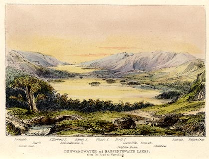 click to enlarge click to enlargeTAT212.jpg Included in The Lakes of England, by W F Topham. printed at bottom:- "DERWENTWATER and BASSENTHWAITE LAKES, / from the road to Watendlath." printed at bottom:- "Swinside. / Lord's Seat. / Barff. / St. Herbert's I. / Bassenthwaite L. / Ramps I. / Vicar's I. / Lord's I. / Skiddaw Dodd. / Castle Hill. / Keswick. / Skiddaw. / Latrigg. / Falcon Crag." item:- Armitt Library : A1067.12 Image © see bottom of page |
|||||||||||||||||||||||||||||||||||||||||||||||||||||||||||||||||||||||||||||||||||||||||
|
|
||||||||||||||||||||||||||||||||||||||||||||||||||||||||||||||||||||||||||||||||||||||||||
| evidence:- | outline view:- Tattersall 1836 placename:- Skiddaw item:- panorama |
|||||||||||||||||||||||||||||||||||||||||||||||||||||||||||||||||||||||||||||||||||||||||
| source data:- | Print, engraving, View from Skiddaw, looking North, Scotland, Northumberland and Cumberland,
drawn by George Tattersall, engraved by W F Topham, published by Sherwood and Co,
Paternoster Row, London, about 1836.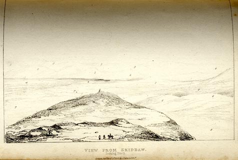 click to enlarge click to enlargeTAT135.jpg Tipped in opposite p.90 of The Lakes of England, by George Tattersall. printed at bottom:- "VIEW FROM SKIDDAW, / looking North." printed at p.90:- "... FOUR VIEWS FROM THE SUMMIT OF SKIDDAW. I. LOOKING NORTH. / 1. Grange Fells, Scotland. / 2. Criffell Hills, Scotland. / 3. Scotch Mountains, Ben Lomond and Ben Nevis. / 4. Solway Frith. / 5. Moffart Hills, Scotland. / 6. Cheviot Hills, Northumberland. / 7. The Lowlands, Cumberland. / 8. Colbeck Fells, Cumberland. / 9. Far point of Skiddaw, Cumberland." item:- Armitt Library : A1204.36 Image © see bottom of page |
|||||||||||||||||||||||||||||||||||||||||||||||||||||||||||||||||||||||||||||||||||||||||
|
|
||||||||||||||||||||||||||||||||||||||||||||||||||||||||||||||||||||||||||||||||||||||||||
| evidence:- | outline view:- Tattersall 1836 placename:- Skiddaw item:- panorama |
|||||||||||||||||||||||||||||||||||||||||||||||||||||||||||||||||||||||||||||||||||||||||
| source data:- | Print, engraving, View from Skiddaw, looking East, Northumberland, Cumberland, Westmorland
and Yorkshire, drawn by George Tattersall, engraved by W F Topham, published by Sherwood
and Co, Paternoster Row, London, about 1836.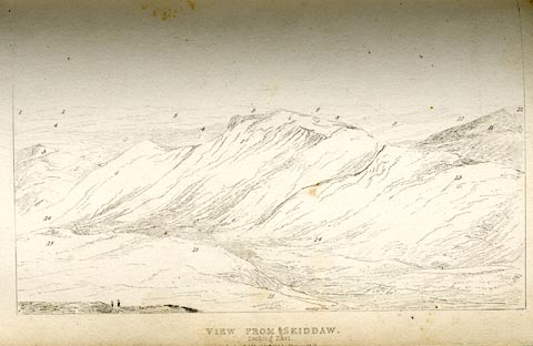 click to enlarge click to enlargeTAT136.jpg Tipped in opposite p.90 of The Lakes of England, by George Tattersall. printed at bottom:- "VIEW FROM SKIDDAW, / looking East. / [London Pubd. ...]" printed at p.90:- "... FOUR VIEWS FROM THE SUMMIT OF SKIDDAW. II. LOOKING EAST. / 1. Cheviot Hills, Northumberland. / 2. Hartside, Northumberland. / 3. High Pike, Cumberland. / 4. Vale of Penrith, Cumberland. / 5. Cross Fell, Cumberland. / 6. Long Brow, Cumberland. / 7. Saddleback, Cumberland. / 8. Black Fell, Cumberland. / 9. Place Fell, Westmoreland. / 10. High Street, Westmoreland. / 11. Helvellyn, Cumberland. / 12. Ingleborough, Yorkshire. / 13. Lonscale Fell, Cumberland. / 14. Skiddaw Forest, Cumberland. / 15. Coldbeck Fells, Cumberland." item:- Armitt Library : A1204.37 Image © see bottom of page |
|||||||||||||||||||||||||||||||||||||||||||||||||||||||||||||||||||||||||||||||||||||||||
|
|
||||||||||||||||||||||||||||||||||||||||||||||||||||||||||||||||||||||||||||||||||||||||||
| evidence:- | outline view:- Tattersall 1836 placename:- Skiddaw item:- panorama |
|||||||||||||||||||||||||||||||||||||||||||||||||||||||||||||||||||||||||||||||||||||||||
| source data:- | Print, engraving, View from Skiddaw, looking South, Cumberland, Westmorland and Lancashire,
drawn by George Tattersall, engraved by W F Topham, published by Sherwood and Co,
Paternoster Row, London, about 1836.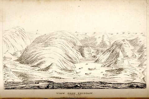 click to enlarge click to enlargeTAT137.jpg Tipped in opposite p.91 of The Lakes of England, by George Tattersall. printed at bottom:- "VIEW FROM SKIDDAW, / looking South. / [London Pubd. ...]" printed at p.91:- "... FOUR VIEWS FROM THE SUMMIT OF SKIDDAW. III. LOOKING SOUTH. / 1. Helvellyn, Cumberland. / 2. Vale of St. John, Cumberland. / 3. Castle Rock, Vale of St. John / 4. The Rigg, Cumberland. / 5. Wythburn, Cumberland. / 6. Shoulthwaite Fell, Cumberland. / 7. Ainside Fells, Westmoreland. / 8. Morecambe Bay. / 9. Cartmel Fells, Lancashire. / 10. Wythburn Fells, Cumberland. / 11. Castle Rigg Fells, Cumberland. / 12. The Stake, Cumberland and Westmoreland. / 13. Pike o'Stickle, Westmoreland. / 14. Coniston Old Man, Lancashire. / 15. Weatherlam, Lancashire. / 16. Bow Fell, Cumberland and Westmoreland. / 17. Glaramara, Cumberland. / 18. Eskhawse, Cumberland. / 19. Great End, Cumberland. / 20. Scawfell Pikes, Cumberland. / 21. Great Gavel, Cumberland. / 22. Birker Fell, Cumberland. / 23. Hindscarth, Cumberland. / 24. Newland's Vale, Cumberland. / 25. Robinson, Cumberland. / 26. Causey Pike, Cumberland. / 27. Goldscarp, Cumberland. / 28. Cat-bells, Cumberland. / 29. Maiden Moor, Cumberland. / 30. Stye Head, Cumberland. / 31. Borrowdale, Cumberland. / 32. Castle Crag, Cumberland. / 33. Grange Fell, Cumberland. / 34. Derwentwater. / 35. St. Herbert's Isle, Derwentwater. / 36. Ramp's Holm, Derwentwater. / 37. Lord's Isle, Derwentwater. / 38. Vicar's Ilse, Derwentwater. / 39. Swinside, Cumberland. / 40. Keswick, Cumberland. / 41. Naddle Fell, Cumberland. / 42. Latrigg, Cumberland. / 43. Skiddaw, Little Man, Cumberland. / 44. Haycock, Cumberland." item:- Armitt Library : A1204.38 Image © see bottom of page |
|||||||||||||||||||||||||||||||||||||||||||||||||||||||||||||||||||||||||||||||||||||||||
|
|
||||||||||||||||||||||||||||||||||||||||||||||||||||||||||||||||||||||||||||||||||||||||||
| evidence:- | outline view:- Tattersall 1836 placename:- Skiddaw item:- panorama |
|||||||||||||||||||||||||||||||||||||||||||||||||||||||||||||||||||||||||||||||||||||||||
| source data:- | Print, engraving, View from Skiddaw, looking West, Cumberland, drawn by George Tattersall,
engraved by W F Topham, published by Sherwood and Co, Paternoster Row, London, about
1836.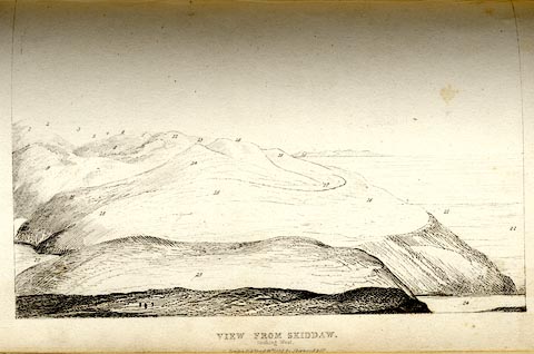 click to enlarge click to enlargeTAT138.jpg Tipped in opposite p.92 of The Lakes of England, by George Tattersall. printed at bottom:- "VIEW FROM SKIDDAW, / looking West. / [London Pubd. ...]" printed at p.92:- "... FOUR VIEWS FROM THE SUMMIT OF SKIDDAW. IV. LOOKING WEST. / 1. Fleetworth, Cumberland. / 2. Kirk Fell, Cumberland. / 3. Yewbarrow, Cumberland. / 4. Hen-coombe, Cumberland. / 5. Pillar, Cumberland. / 6. Green Gavel, Cumberland. / 7. Red Pike, Cumberland. / 8. High Stile, Cumberland. / 9. Robinson, Cumberland. / 10. Newland's Vale, Cumberland. / 11. Causey Pike, Cumberland. / 12. Grasmoor, Cumberland. / 13. Whiteless Pike, Cumberland. / 14. Grisedale Pike, Cumberland. / 15. Thornthwaite, Cumberland. / 16. Lord's Seat, Cumberland. / 17. Kirk Fell, Cumberland. / 18. Blake Fell, Cumberland. / 19. Dent, Cumberland. / 20. Isle of Man. / 21. Low Lands, Cumberland. / 22. Cockermouth, Cumberland. / 23. Wythrop, Cumberland. / 24. Bassenthwaite Lake, Cumberland. / 25. Car Sleddam, Cumberland." item:- Armitt Library : A1204.39 Image © see bottom of page |
|||||||||||||||||||||||||||||||||||||||||||||||||||||||||||||||||||||||||||||||||||||||||
|
|
||||||||||||||||||||||||||||||||||||||||||||||||||||||||||||||||||||||||||||||||||||||||||
| evidence:- | outline view:- Tattersall 1836 placename:- Skiddaw |
|||||||||||||||||||||||||||||||||||||||||||||||||||||||||||||||||||||||||||||||||||||||||
| source data:- | Print, engraving, Derwentwater and Bassenthwaite Lakes, from the road to Watenflath,
Cumberland, drawn by George Tattersall, engraved by W F Topham, published by Sherwood
and Co, Paternoster Row, London, about 1836.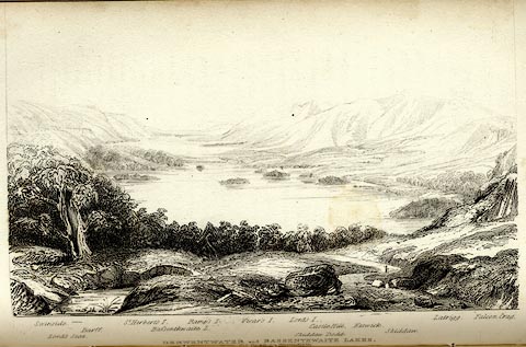 click to enlarge click to enlargeTAT130.jpg The print is captioned with mountain names and acts as an outline view. Tipped in opposite p.77 of The Lakes of England, by George Tattersall. printed at bottom:- "DERWENTWATER and BASSENTHWAITE LAKES, / from the road to Watendlath." printed at bottom left to right:- "Swinside. / Lord's Seat. / Barff. / St. Herbert's I. / Bassenthwaite L. / Ramp's I. / Vicar's I. / Lord's I. / Skiddaw Dodd. / Castle Hill. / Keswick. / Skiddaw. / Latrigg. / Falcon Crag." item:- Armitt Library : A1204.31 Image © see bottom of page |
|||||||||||||||||||||||||||||||||||||||||||||||||||||||||||||||||||||||||||||||||||||||||
|
|
||||||||||||||||||||||||||||||||||||||||||||||||||||||||||||||||||||||||||||||||||||||||||
| evidence:- | old print:- Green 1819 placename:- Skiddaw |
|||||||||||||||||||||||||||||||||||||||||||||||||||||||||||||||||||||||||||||||||||||||||
| source data:- | Print, aquatint, Derwent Water distance Skiddaw, Cumberland, by William Green, 1819,
published by R Lough and Co, Chronicle Office, Finkle Street, Kendal, and others,
1820.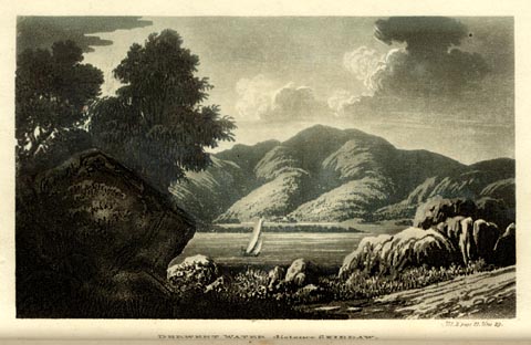 click to enlarge click to enlargeGN0118.jpg Tipped in opposite vol.2 p.31 of The Tourist's New Guide, by William Green. printed at bottom right, centre:- "Vol.2, page 31, line 29. / DERWENT WATER distance SKIDDAW. / Published at Ambleside, Augt. 1. 1819, by Wm. Green." item:- Armitt Library : A1141.19 Image © see bottom of page |
|||||||||||||||||||||||||||||||||||||||||||||||||||||||||||||||||||||||||||||||||||||||||
|
|
||||||||||||||||||||||||||||||||||||||||||||||||||||||||||||||||||||||||||||||||||||||||||
| evidence:- | old drawing:- Smith 1746 B placename:- Mount Skiddow |
|||||||||||||||||||||||||||||||||||||||||||||||||||||||||||||||||||||||||||||||||||||||||
| source data:- | Drawing, pencil and ink, Appearance of Mount Skiddow and the Borrodale Fells, in a
Survey of the Coast of Cumberland, by George Smith, 1746.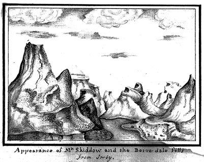 click to enlarge click to enlargeSM2104.jpg ms at bottom:- "Appearance of Mt. Skiddow and the Borro-dale fells / from Ireby." item:- Carlisle Library : 5.4 Image © Carlisle Library |
|||||||||||||||||||||||||||||||||||||||||||||||||||||||||||||||||||||||||||||||||||||||||
|
|
||||||||||||||||||||||||||||||||||||||||||||||||||||||||||||||||||||||||||||||||||||||||||
| evidence:- | old postcard:- placename:- Skiddaw |
|||||||||||||||||||||||||||||||||||||||||||||||||||||||||||||||||||||||||||||||||||||||||
| source data:- | Postcard, colour photograph, Dewent Water and Skiddaw from Falcon Crag, by Keswick,
Cumberland, published by J Arthur Dixon, Newport, Isle of Wight, about 1966?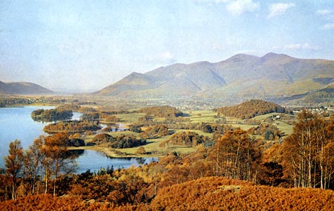 click to enlarge click to enlargePH0106.jpg printed at rev:- "Derwentwater, Keswick / Backed by Skiddaw, from below Falcon Crag, ... / ... / Printed and Published by J. Arthur Dixon Ltd., Newport, I. W. England" item:- JandMN : 974 Image © see bottom of page |
|||||||||||||||||||||||||||||||||||||||||||||||||||||||||||||||||||||||||||||||||||||||||
|
|
||||||||||||||||||||||||||||||||||||||||||||||||||||||||||||||||||||||||||||||||||||||||||
| evidence:- | old print:- Gresham Publishing 1900s placename:- Skiddaw |
|||||||||||||||||||||||||||||||||||||||||||||||||||||||||||||||||||||||||||||||||||||||||
| source data:- | Print, colour halftone, Bassenthwaite Lake and Skiddaw, Cumberland, by Ernest W Haslehurst,
published by The Gresham Publishing Co, 66 Chandos Street, London, 1900s?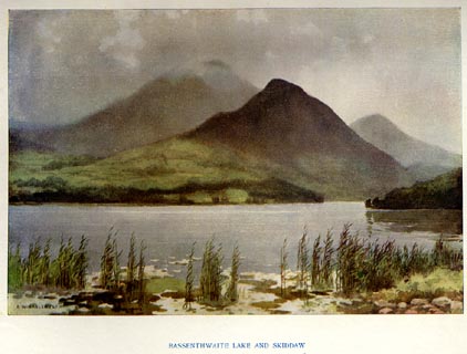 click to enlarge click to enlargePR1566.jpg Tipped in opposite p.36 of The English Lakes section of a volume of Our Beautiful Homeland. printed at bottom:- "BASSENTHWAITE LAKE AND SKIDDAW" printed at lower left:- "E. W. HASLEHURST" item:- JandMN : 381.8 Image © see bottom of page |
|||||||||||||||||||||||||||||||||||||||||||||||||||||||||||||||||||||||||||||||||||||||||
|
|
||||||||||||||||||||||||||||||||||||||||||||||||||||||||||||||||||||||||||||||||||||||||||
| evidence:- | old print:- Goodwin 1887 (edn 1890) placename:- Skiddaw |
|||||||||||||||||||||||||||||||||||||||||||||||||||||||||||||||||||||||||||||||||||||||||
| source data:- | Print, etching? Skiddaw, Cumberland, by Harry Goodwin, published by Swan Sonnenschein
and Co, Paternoster Square, London, 1890.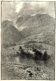 click to enlarge click to enlargePR1619.jpg Tipped in opposite p.232 of Through the Wordsworth Country, by William Knight. item:- JandMN : 382.49 Image © see bottom of page |
|||||||||||||||||||||||||||||||||||||||||||||||||||||||||||||||||||||||||||||||||||||||||
|
|
||||||||||||||||||||||||||||||||||||||||||||||||||||||||||||||||||||||||||||||||||||||||||
| evidence:- | old print:- Sylvan 1847 placename:- Skiddaw |
|||||||||||||||||||||||||||||||||||||||||||||||||||||||||||||||||||||||||||||||||||||||||
| source data:- | Print, engraving, Skiddaw, seen near Lodore, Cumberland, published by John Johnstone,
Paternoster Row, London, et al, 1847.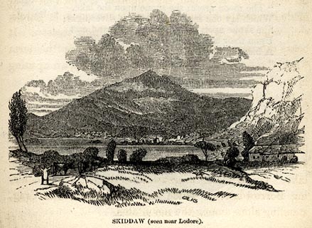 click to enlarge click to enlargeSYL147.jpg On p.195 of Sylvan's Pictorial Guide to the English Lakes. printed at bottom:- "SKIDDAW (seen near Lodore)." item:- Armitt Library : A1201.47 Image © see bottom of page |
|||||||||||||||||||||||||||||||||||||||||||||||||||||||||||||||||||||||||||||||||||||||||
|
|
||||||||||||||||||||||||||||||||||||||||||||||||||||||||||||||||||||||||||||||||||||||||||
| evidence:- | old drawing:- placename:- Skiddaw |
|||||||||||||||||||||||||||||||||||||||||||||||||||||||||||||||||||||||||||||||||||||||||
| source data:- | Drawing, Derwentwater and Skiddaw, Cumberland, by William Havell, 1800s-10s.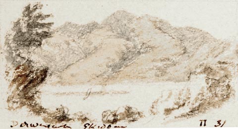 click to enlarge click to enlargePR1408.jpg View of Derwent Water from above with Skiddaw in the background. One of a set of twenty views of the lake district executed by the artist on one sheet of paper. at bottom:- "Derwentwater Skiddaw II 31" item:- Tullie House Museum : 2009.89.52 Image © Tullie House Museum |
|||||||||||||||||||||||||||||||||||||||||||||||||||||||||||||||||||||||||||||||||||||||||
|
|
||||||||||||||||||||||||||||||||||||||||||||||||||||||||||||||||||||||||||||||||||||||||||
| evidence:- | outline view:- Jenkinson 1875 placename:- Skiddaw |
|||||||||||||||||||||||||||||||||||||||||||||||||||||||||||||||||||||||||||||||||||||||||
| source data:- | Print, lithograph, outline view, Panoramic Sketches from Helvellyn, Westmorland, by
Edwin A Pettitt, London, published by Edward Stanford, 55 Charing Cross, London, 1875. click to enlarge click to enlargeJk01E1.jpg "... Skiddaw ..." item:- JandMN : 28.5 Image © see bottom of page |
|||||||||||||||||||||||||||||||||||||||||||||||||||||||||||||||||||||||||||||||||||||||||
|
|
||||||||||||||||||||||||||||||||||||||||||||||||||||||||||||||||||||||||||||||||||||||||||
| evidence:- | outline view:- Jenkinson 1875 placename:- Skiddaw |
|||||||||||||||||||||||||||||||||||||||||||||||||||||||||||||||||||||||||||||||||||||||||
| source data:- | Print, lithograph, outline view, Panoramic Sketches from Scawfell Pike, Cumberland,
by Edwin A Pettitt, London, published by Edward Stanford, 55 Charing Cross, London,
1875. click to enlarge click to enlargeJk01E3.jpg "... Skiddaw ..." item:- JandMN : 28.9 Image © see bottom of page |
|||||||||||||||||||||||||||||||||||||||||||||||||||||||||||||||||||||||||||||||||||||||||
|
|
||||||||||||||||||||||||||||||||||||||||||||||||||||||||||||||||||||||||||||||||||||||||||
| evidence:- | old print:- placename:- Skiddaw |
|||||||||||||||||||||||||||||||||||||||||||||||||||||||||||||||||||||||||||||||||||||||||
| source data:- | Print, uncoloured engraving, Skiddaw and Saddleback from Bolton Moor, Cumberland,
drawn by C Stansfield, engraved by R Brandard, published by R Cadel, Edinburgh, late
19th century?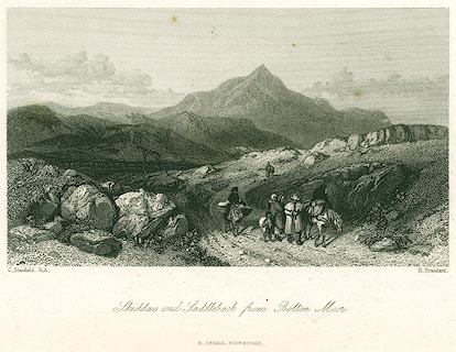 click to enlarge click to enlargePR0299.jpg A family travelling on a bleak road; the viewpoint is about NY2638, perhaps on the road from Caldbeck to Boltongate? printed at bottom left, right, centre:- "C. Stansfield, R.S. / R. Brandard. / Skiddaw and Saddleback from Bolton Moor. / R. CADELL, EDINBURGH." item:- Dove Cottage : 2008.107.299 Image © see bottom of page |
|||||||||||||||||||||||||||||||||||||||||||||||||||||||||||||||||||||||||||||||||||||||||
|
|
||||||||||||||||||||||||||||||||||||||||||||||||||||||||||||||||||||||||||||||||||||||||||
| evidence:- | old print:- placename:- Skiddaw |
|||||||||||||||||||||||||||||||||||||||||||||||||||||||||||||||||||||||||||||||||||||||||
| source data:- | Print, uncoloured engraving, Derwent Water and Skiddaw, Cumberland, engraved by M
Jackson, published late 19th century?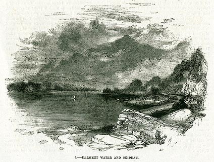 click to enlarge click to enlargePR0343.jpg On page 241 of The Land We Live In. printed at lower centre:- "M. JACKSON. SC" printed at bottom:- "6.- DERWENT WATER AND SKIDDAW." item:- Dove Cottage : 2008.107.343 Image © see bottom of page |
|||||||||||||||||||||||||||||||||||||||||||||||||||||||||||||||||||||||||||||||||||||||||
|
|
||||||||||||||||||||||||||||||||||||||||||||||||||||||||||||||||||||||||||||||||||||||||||
| evidence:- | old print:- Nelson 1859 placename:- Skiddaw |
|||||||||||||||||||||||||||||||||||||||||||||||||||||||||||||||||||||||||||||||||||||||||
| source data:- | Print, engraving, Bassenthwaite Lake and Skiddaw, drawn by Keeley Halswelle, Edinburgh,
published by T Nelson and Sons, Paternoster Row, London, and Edinburgh and New York,
United States, 1859.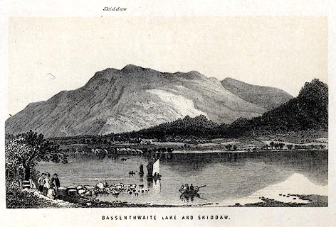 click to enlarge click to enlargeNS0101.jpg Tipped in oppposite p.22 of a guide book, The English Lakes. printed at bottom:- "BASSENTHWAITE LAKE AND SKIDDAW." item:- JandMN : 336.3 Image © see bottom of page |
|||||||||||||||||||||||||||||||||||||||||||||||||||||||||||||||||||||||||||||||||||||||||
|
|
||||||||||||||||||||||||||||||||||||||||||||||||||||||||||||||||||||||||||||||||||||||||||
| evidence:- | outline view:- Black 1856 (23rd edn 1900) placename:- Skiddaw |
|||||||||||||||||||||||||||||||||||||||||||||||||||||||||||||||||||||||||||||||||||||||||
| source data:- | Print, lithograph, Outline Views, Windermere - Mountains as seen from the North End
of Belle Isle, Windermere, and Mountains as seen from Biscay How, Bowness, by J Flintoft,
Keswick, Cumberland, engraved by R Mason, Edinburgh, Lothian, about 1900. click to enlarge click to enlargeBC08E1.jpg "... 17 Skiddaw's Top ..." item:- JandMN : 37.4 Image © see bottom of page |
|||||||||||||||||||||||||||||||||||||||||||||||||||||||||||||||||||||||||||||||||||||||||
|
|
||||||||||||||||||||||||||||||||||||||||||||||||||||||||||||||||||||||||||||||||||||||||||
| evidence:- | outline view:- Black 1856 (23rd edn 1900) placename:- Skiddaw |
|||||||||||||||||||||||||||||||||||||||||||||||||||||||||||||||||||||||||||||||||||||||||
| source data:- | Print, lithograph, Outline Views, Skiddaw and Derwent Water - Mountains as seen at
Lodore Hotel, and Mountains as seen at the Third Gate on Ascending Latrigg on the
Way to Skiddaw, by J Flintoft, Keswick, Cumberland, engraved by R Mason, Edinburgh,
Lothian, about 1900. click to enlarge click to enlargeBC08E4.jpg "... 9 Skiddaw ..." item:- JandMN : 37.14 Image © see bottom of page |
|||||||||||||||||||||||||||||||||||||||||||||||||||||||||||||||||||||||||||||||||||||||||
|
|
||||||||||||||||||||||||||||||||||||||||||||||||||||||||||||||||||||||||||||||||||||||||||
| evidence:- | old print:- Pyne 1853 |
|||||||||||||||||||||||||||||||||||||||||||||||||||||||||||||||||||||||||||||||||||||||||
| source data:- | Drawn by James Barker Pyne, 1848-1853, lithographed by T Picken, 1859. click to enlarge click to enlargePY23.jpg "Bassenthwaite Lake, Vale and Village" item:- JandMN : 97.20 Image © see bottom of page |
|||||||||||||||||||||||||||||||||||||||||||||||||||||||||||||||||||||||||||||||||||||||||
|
|
||||||||||||||||||||||||||||||||||||||||||||||||||||||||||||||||||||||||||||||||||||||||||
| evidence:- | old print:- Adams 1852 placename:- Skiddaw |
|||||||||||||||||||||||||||||||||||||||||||||||||||||||||||||||||||||||||||||||||||||||||
| source data:- | Print, engraving, Keswick, Skiddaw, by F G Delamotte, published by W J Adams, 59 Fleet
Street, London, 1852.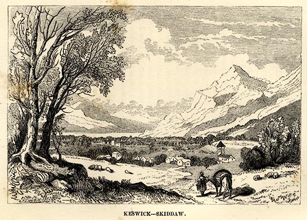 click to enlarge click to enlargeAD03E3.jpg Tipped in opp.p.45 in Adams's Pocket Descriptive Guide to the Lake District. printed at lower left:- "F. DelaMotte" printed at bottom:- "KESWICK - SKIDDAW" item:- Armitt Library : A1117.4 Image © see bottom of page |
|||||||||||||||||||||||||||||||||||||||||||||||||||||||||||||||||||||||||||||||||||||||||
|
|
||||||||||||||||||||||||||||||||||||||||||||||||||||||||||||||||||||||||||||||||||||||||||
| evidence:- | old print:- placename:- Skiddaw |
|||||||||||||||||||||||||||||||||||||||||||||||||||||||||||||||||||||||||||||||||||||||||
| source data:- | Print, uncoloured engraving, Skiddaw from Bassenthwaite Lake, Bassenthwaite, Cumberland,
by ?B Foster, engraved by E Evans, 1850s-60s?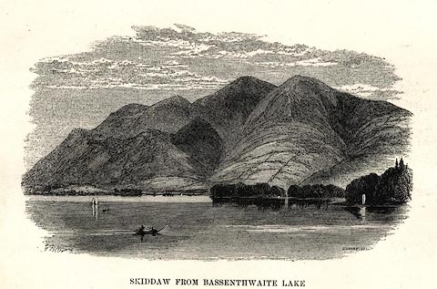 click to enlarge click to enlargePR0495.jpg printed at bottom left, right, centre:- "[B] Foster / E. EVANS SC. / SKIDDAW FROM BASSENTHWAITE LAKE" item:- Dove Cottage : 2008.107.444 Image © see bottom of page |
|||||||||||||||||||||||||||||||||||||||||||||||||||||||||||||||||||||||||||||||||||||||||
|
|
||||||||||||||||||||||||||||||||||||||||||||||||||||||||||||||||||||||||||||||||||||||||||
| evidence:- | old print:- Harwood 1842 |
|||||||||||||||||||||||||||||||||||||||||||||||||||||||||||||||||||||||||||||||||||||||||
| source data:- | Print, uncoloured engraving, Skiddaw and Bassenthwaite Water, Cumberland, engraved
and published by John Harwood, 26 Fenchurch Street, London, 1845.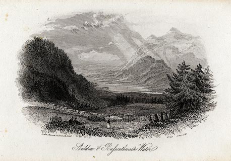 click to enlarge click to enlargeHRW214.jpg printed at bottom left, right, centre:- "London, J. Harwood, 26, Fenchurch Street. / No.597 June 1. 1845. / Skiddaw and Bassenthwaite Water." item:- JandMN : 166.14 Image © see bottom of page |
|||||||||||||||||||||||||||||||||||||||||||||||||||||||||||||||||||||||||||||||||||||||||
|
|
||||||||||||||||||||||||||||||||||||||||||||||||||||||||||||||||||||||||||||||||||||||||||
| evidence:- | old print:- Harwood 1842 |
|||||||||||||||||||||||||||||||||||||||||||||||||||||||||||||||||||||||||||||||||||||||||
| source data:- | Print, uncoloured engraving, Derwentwater and Keswick from Skiddaw, Cumberland, engraved
and published by John and Frederick Harwood, 26 Fenchurch Street, London, about 1842.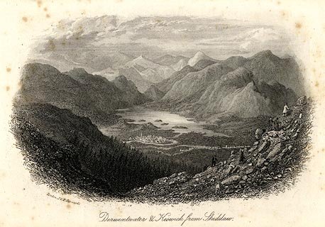 click to enlarge click to enlargeHRW212.jpg Notice the tourists making the ascent of Skiddaw. printed at bottom left, centre:- "London, J &F. Harwood. / Derwentwater and Keswick from Skiddaw." item:- JandMN : 166.12 Image © see bottom of page |
|||||||||||||||||||||||||||||||||||||||||||||||||||||||||||||||||||||||||||||||||||||||||
|
|
||||||||||||||||||||||||||||||||||||||||||||||||||||||||||||||||||||||||||||||||||||||||||
| evidence:- | outline view:- Black 1841 (3rd edn 1846) placename:- Skiddaw |
|||||||||||||||||||||||||||||||||||||||||||||||||||||||||||||||||||||||||||||||||||||||||
| source data:- | Print, engraving, outline view, Mountains as seen from the North End of Belle Isle,
Windermere, and Mountains as seen from Bisket How, Bowness, by J Flintoft, Keswick,
Cumberland, engraved by R Mason, Edinburgh, about 1844.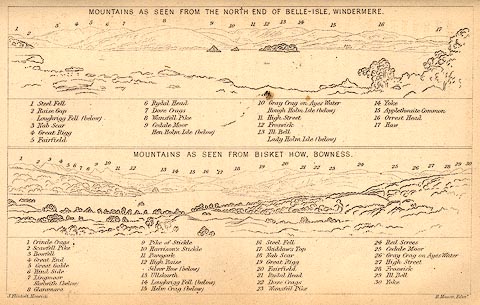 click to enlarge click to enlargeBC02E1.jpg "... 17 Skiddaw's Top ..." item:- JandMN : 32.3 Image © see bottom of page |
|||||||||||||||||||||||||||||||||||||||||||||||||||||||||||||||||||||||||||||||||||||||||
|
|
||||||||||||||||||||||||||||||||||||||||||||||||||||||||||||||||||||||||||||||||||||||||||
| evidence:- | outline view:- Black 1841 (3rd edn 1846) placename:- Skiddaw |
|||||||||||||||||||||||||||||||||||||||||||||||||||||||||||||||||||||||||||||||||||||||||
| source data:- | Print, engraving, outline view, Mountains as seen at Lowdore Inn, and Mountains as
seen at the Third Gate on Ascending Latrigg on the Way to Skiddaw, by J Flintoft,
Keswick, Cumberland, engraved by R Mason, Edinburgh, Lothian, about 1846.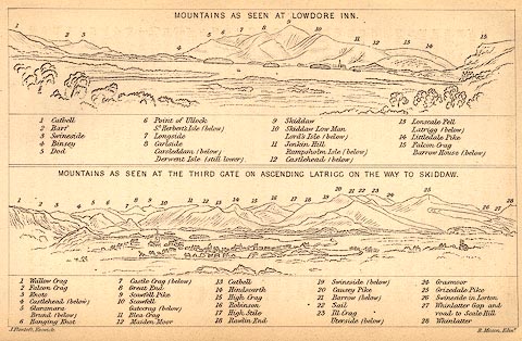 click to enlarge click to enlargeBC02E4.jpg "... 9 Skiddaw ..." item:- JandMN : 32.7 Image © see bottom of page |
|||||||||||||||||||||||||||||||||||||||||||||||||||||||||||||||||||||||||||||||||||||||||
|
|
||||||||||||||||||||||||||||||||||||||||||||||||||||||||||||||||||||||||||||||||||||||||||
| evidence:- | outline view:- placename:- Skiddaw |
|||||||||||||||||||||||||||||||||||||||||||||||||||||||||||||||||||||||||||||||||||||||||
| source data:- | Print, uncoloured engraving, Derwentwater and Bassenthwaite Lakes from the Road to
Watendlath, Cumberland, published by Sherwood and Co, London, 1836?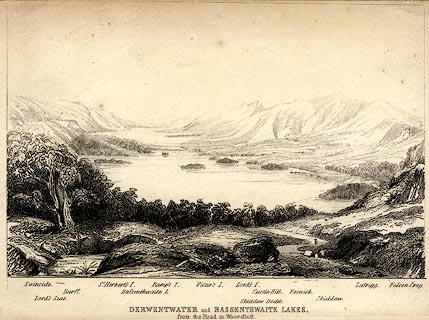 click to enlarge click to enlargePR0370.jpg The view is from just above Ashness Bridge. Objects in the view are identified by a caption at the bottom (unfortunately the print is pale, so some objects are unclear, and the caption seems to be a little misaligned) - Swinside, Lord's Seat, Barff, St. Herbert's I., Bassenthwaite L., Ramp's I., Vicar's I., Lord's I., Skiddaw Dodd, Castle Hill, Keswick, Skiddaw, Latrigg, Falcon Crag. printed at bottom:- "DERWENTWATER and BASSENTHWAITE LAKES. / from the Road to Watendlath." item:- Dove Cottage : 2008.107.370 Image © see bottom of page |
|||||||||||||||||||||||||||||||||||||||||||||||||||||||||||||||||||||||||||||||||||||||||
|
|
||||||||||||||||||||||||||||||||||||||||||||||||||||||||||||||||||||||||||||||||||||||||||
| evidence:- | old print:- Rose 1832-35 (vol.1 no.37) placename:- Skiddaw |
|||||||||||||||||||||||||||||||||||||||||||||||||||||||||||||||||||||||||||||||||||||||||
| source data:- | Print, hand coloured engraving, Skiddaw, from Applethwaite, Cumberland, drawn by H
Gastineau, engraved by J C Bentley, published by Fisher, Son and Co, London, 1833.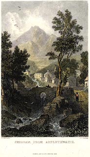 click to enlarge click to enlargePR0013.jpg vol.1 pl.37 in the set of prints, Westmorland, Cumberland, Durham and Northumberland Illustrated. printed at bottom left, right, centre:- "H. Gastineau. / J. C. Bentley. / SKIDDAW, FROM APPLETHWAITE. / FISHER, SON &CO. LONDON, 1833." item:- Dove Cottage : 2008.107.13 Image © see bottom of page |
|||||||||||||||||||||||||||||||||||||||||||||||||||||||||||||||||||||||||||||||||||||||||
|
|
||||||||||||||||||||||||||||||||||||||||||||||||||||||||||||||||||||||||||||||||||||||||||
| evidence:- | old print:- placename:- Skiddaw |
|||||||||||||||||||||||||||||||||||||||||||||||||||||||||||||||||||||||||||||||||||||||||
| source data:- | Print, uncoloured engraving, Distant View of Skiddaw, Cumberland, drawn by P Dewint,
engraved by E Finden, published by Charles Tilt, 86 Fleet Street, London, 1830.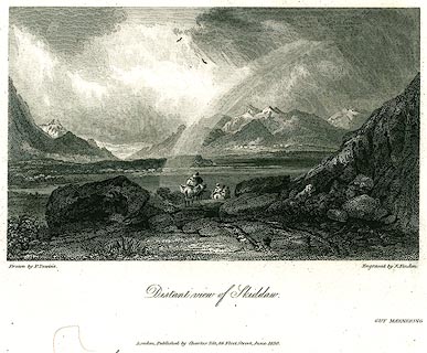 click to enlarge click to enlargePR0275.jpg printed at bottom left, right, centre:- "Drawn by P. Dewint. / Engraved by E. Finden. / Distant View of Skiddaw. / London. Published by Charles Tilt, 86, Fleet Street, June 1830." item:- Dove Cottage : 2008.107.275 Image © see bottom of page |
|||||||||||||||||||||||||||||||||||||||||||||||||||||||||||||||||||||||||||||||||||||||||
|
|
||||||||||||||||||||||||||||||||||||||||||||||||||||||||||||||||||||||||||||||||||||||||||
| evidence:- | old print:- Fielding 1822 (plate 5) |
|||||||||||||||||||||||||||||||||||||||||||||||||||||||||||||||||||||||||||||||||||||||||
| source data:- | Print, coloured aquatint, Skiddaw over Derwent Water, drawn by Theodore Fielding,
published by Thomas McLean, 26 Haymarket, and by Howlett and Brimmer, Columbian Press,
10 Frith Street, London, 1822.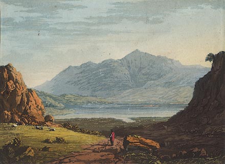 click to enlarge click to enlargeBNV39.jpg Plate 5 in Cumberland, Westmorland, and Lancashire Illustrated ... item:- private collection : 78 Image © see bottom of page |
|||||||||||||||||||||||||||||||||||||||||||||||||||||||||||||||||||||||||||||||||||||||||
|
|
||||||||||||||||||||||||||||||||||||||||||||||||||||||||||||||||||||||||||||||||||||||||||
| evidence:- | old print:- placename:- Skiddaw |
|||||||||||||||||||||||||||||||||||||||||||||||||||||||||||||||||||||||||||||||||||||||||
| source data:- | Print, uncoloured engraving, Skiddaw, drawn by J M W Turner, engraved by W Miller,
1800s?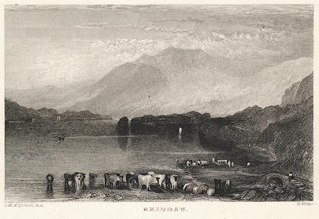 click to enlarge click to enlargePR0379.jpg printed at bottom left, right, centre:- "J. M. W. Turner R.A. / W. Miller. / SKIDDAW." item:- Dove Cottage : 2008.107.379 Image © see bottom of page |
|||||||||||||||||||||||||||||||||||||||||||||||||||||||||||||||||||||||||||||||||||||||||
|
|
||||||||||||||||||||||||||||||||||||||||||||||||||||||||||||||||||||||||||||||||||||||||||
| evidence:- | old print:- Green 1790s-1820s placename:- Skiddaw |
|||||||||||||||||||||||||||||||||||||||||||||||||||||||||||||||||||||||||||||||||||||||||
| source data:- | Print, uncoloured aquatint, Skiddaw, taken near Castle Crag, Underskiddaw, Cumberland,
drawn, engraved and published by William Green, Ambleside, 1804.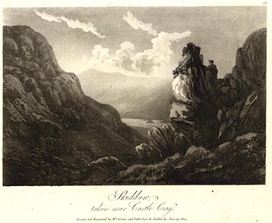 click to enlarge click to enlargePR0516.jpg Plate 18 from some series. printed at bottom:- "Skiddaw, / taken near Castle Crag. / Drawn and Engraved by Wm. Green, and Published at Ambleside, June 24, 1804." item:- Dove Cottage : 2008.107.465 Image © see bottom of page |
|||||||||||||||||||||||||||||||||||||||||||||||||||||||||||||||||||||||||||||||||||||||||
|
|
||||||||||||||||||||||||||||||||||||||||||||||||||||||||||||||||||||||||||||||||||||||||||
| evidence:- | old print with text:- Farington 1789 (plate 3) item:- geology |
|||||||||||||||||||||||||||||||||||||||||||||||||||||||||||||||||||||||||||||||||||||||||
| source data:- | Print, engraving, View of Skiddaw and Derwentwater, painted by Joseph Farington, engraved
by B T Pouncy, published by W Byrne, 79 Titchfield Street, London, 1785.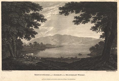 click to enlarge click to enlargeBMZ89.jpg Taken from the lake margin in Brandlehow Park. Plate 3 from Views of the Lakes, &c, in Cumberland and Westmorland, published 1789; with descriptive text:- "A VIEW of SKIDDAW and DERWENTWATER." item:- Dove Cottage : Lowther.53 Image © see bottom of page |
|||||||||||||||||||||||||||||||||||||||||||||||||||||||||||||||||||||||||||||||||||||||||
|
|
||||||||||||||||||||||||||||||||||||||||||||||||||||||||||||||||||||||||||||||||||||||||||
 ascent 1794 ascent 1794 |
||||||||||||||||||||||||||||||||||||||||||||||||||||||||||||||||||||||||||||||||||||||||||
|
|
||||||||||||||||||||||||||||||||||||||||||||||||||||||||||||||||||||||||||||||||||||||||||
| ascent 1827 |
||||||||||||||||||||||||||||||||||||||||||||||||||||||||||||||||||||||||||||||||||||||||||
|
|
||||||||||||||||||||||||||||||||||||||||||||||||||||||||||||||||||||||||||||||||||||||||||
| ascent 1855 |
||||||||||||||||||||||||||||||||||||||||||||||||||||||||||||||||||||||||||||||||||||||||||
|
|
||||||||||||||||||||||||||||||||||||||||||||||||||||||||||||||||||||||||||||||||||||||||||
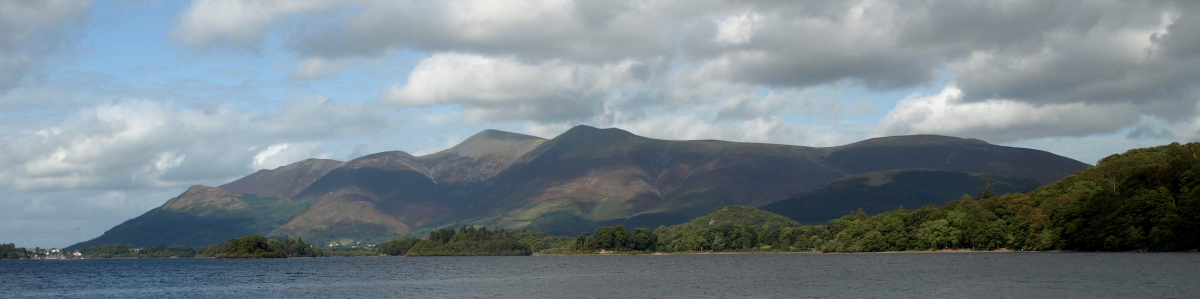 Click to enlarge BRP02.jpg From the south. (taken 23.9.2009)  Click to enlarge BPI51.jpg From the north. (taken 14.6.2008)  Click to enlarge BTP53.jpg From the north. (taken 5.10.2010) 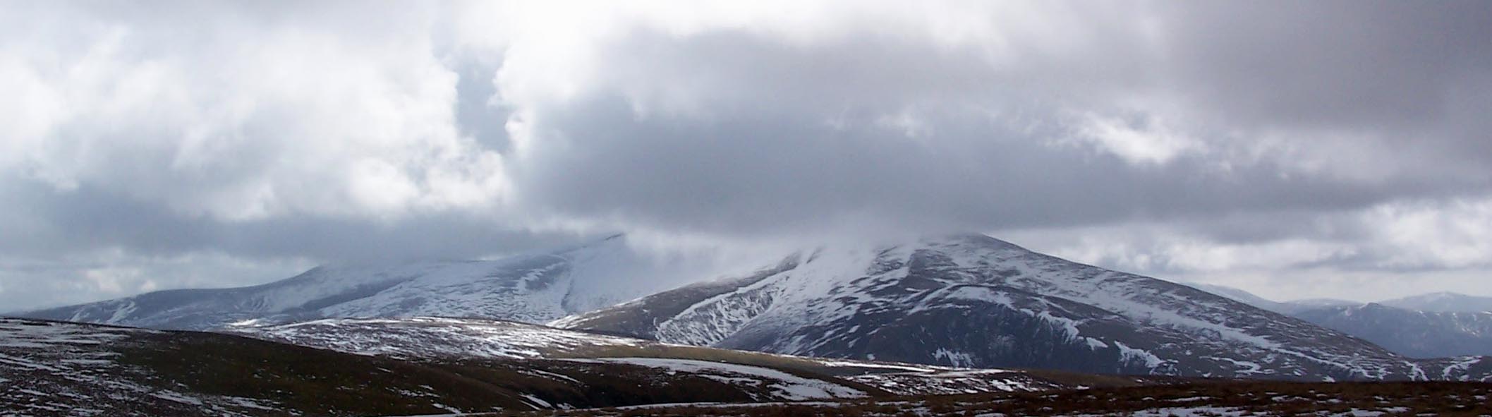 Click to enlarge BSL66.jpg From Great Sca Fell. (taken 4.4.2010) 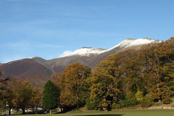 BXP66.jpg From Lower Fitz Park, Keswick. (taken 4.11.2012) 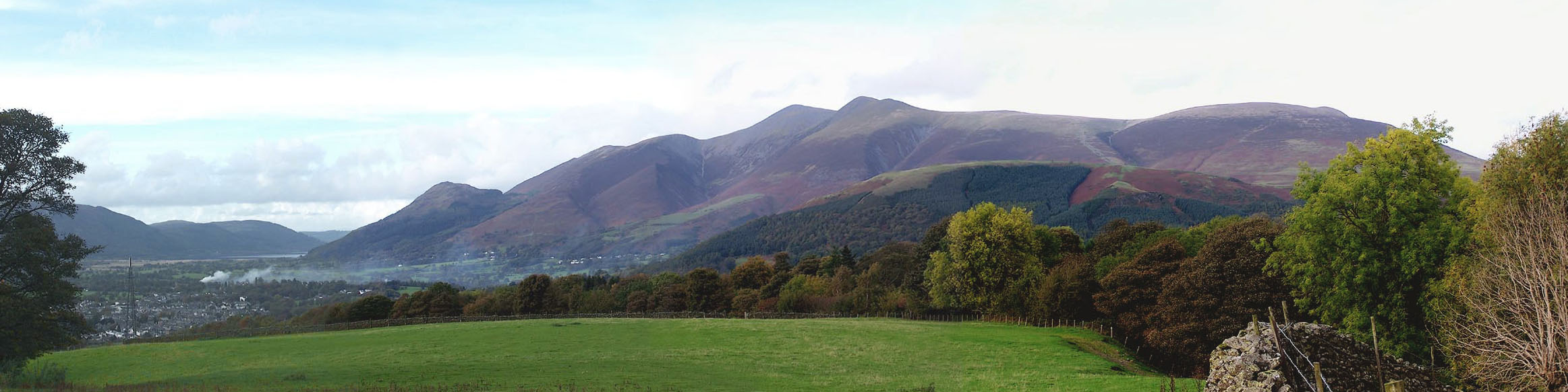 Click to enlarge BMX41.jpg Keswick, Dodd, Skiddaw, Lonscale Fell, Blease Fell and Latrigg, viewed from the south. (taken 23.10.2006)  BPR46.jpg Skiddaw and Little Man from the east. (taken 26.9.2008) |
||||||||||||||||||||||||||||||||||||||||||||||||||||||||||||||||||||||||||||||||||||||||||
|
|
||||||||||||||||||||||||||||||||||||||||||||||||||||||||||||||||||||||||||||||||||||||||||
| notes:- |
Mary Lamb, sister of Charles, climbed to the top in 1802:- |
|||||||||||||||||||||||||||||||||||||||||||||||||||||||||||||||||||||||||||||||||||||||||
| "Oh, its fine black head, and the bleak air atop of it, with a prospect of mountains
all about and about, making you giddy. It was a day that will stand out like a mountain,
I am sure, all my life." |
||||||||||||||||||||||||||||||||||||||||||||||||||||||||||||||||||||||||||||||||||||||||||
| Baron 1925 |
||||||||||||||||||||||||||||||||||||||||||||||||||||||||||||||||||||||||||||||||||||||||||
|
|
||||||||||||||||||||||||||||||||||||||||||||||||||||||||||||||||||||||||||||||||||||||||||
| notes:- |
A local rhyme has:- |
|||||||||||||||||||||||||||||||||||||||||||||||||||||||||||||||||||||||||||||||||||||||||
| "Laal brag it is for any man To clim' oop Skidder side, Auld wives and barns on jackasses To tippy twop ma ride" |
||||||||||||||||||||||||||||||||||||||||||||||||||||||||||||||||||||||||||||||||||||||||||
| Baron 1925 |
||||||||||||||||||||||||||||||||||||||||||||||||||||||||||||||||||||||||||||||||||||||||||
|
|
||||||||||||||||||||||||||||||||||||||||||||||||||||||||||||||||||||||||||||||||||||||||||
| notes:- |
This mountain is a 'Furth Munro'. |
|||||||||||||||||||||||||||||||||||||||||||||||||||||||||||||||||||||||||||||||||||||||||
|
|
||||||||||||||||||||||||||||||||||||||||||||||||||||||||||||||||||||||||||||||||||||||||||
Lakes Guides menu.