 Ford 1839 map SD49


|

|
|
|
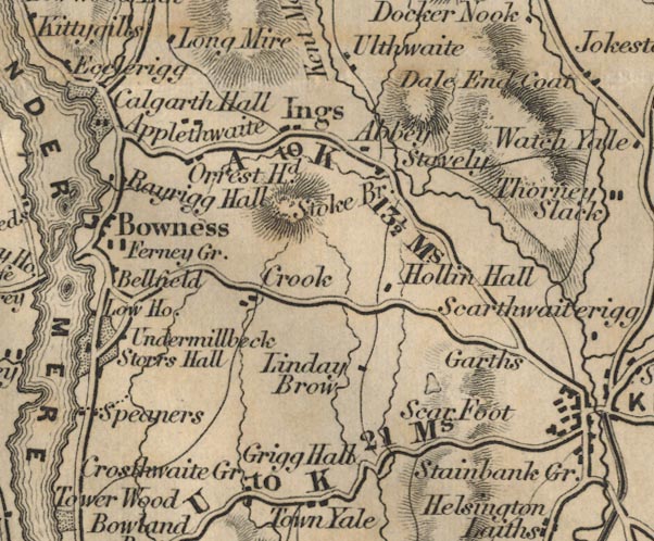
gazetteer links places may or may not be labelled on the map |
||

|
-- Abbey Hotel -- "Abbey" |
|
|
|
-- Applethwaite -- "Applethwaite" |
|
|
|
-- Belsfield, The -- "Bellfield" |
|
|
|
-- Crook -- "Crook" |
|
|
|
-- Crosthwaite -- "Crosthwaite Gr." |
|
|
|
-- Cunswick Tarn |
|
|
|
-- Ferney Green -- "Ferney Gr." |
|
|
|
-- Gregg Hall -- "Grigg Hall" |
|
|
|
-- Hollin Hall -- "Hollin Hall" |
|
|
|
-- Ings -- "Ings" |
|
|
|
-- Lindreth Brow -- "Linday Brow" |
|
|
|
-- Orrest Head -- "Orrest Hd." |
|
|
|
-- Rayrigg Hall -- "Rayrigg Hall" |
|
|
|
-- Kendal to Newby Bridge -- "U to K 21 Ms." |
|
|
|
-- Kendal to Windermere -- "A to K 13 1/2 Ms." |
|
|
|
-- Windermere to Ambleside -- "A to K 13 1/2 Ms." |
|
|
|
-- Scar Foot -- "Scar Foot" |
|
|
|
-- Staveley -- "Stavely" |
|
|
|
-- Stockbridge -- "Stoke Br." |
|
|
|
-- Undermillbeck -- "Undermillbeck" |
|
|
civil parishes The area roughly includes parts of parishes:- Crosthwaite and Lyth Cartmel Fell Helsington Strickland Ketel Windermere Underbarrow and Bradleyfield Hugill Strickland Roger Over Staveley Nether Staveley Crook |
||
|
|
||
|
|
Lakes Guides menu. | |