 Old Cumbria Gazetteer
 |
 |
|
| Hollin Hall, Crook | ||
| Hollin Hall | ||
| Hollin How | ||
| civil parish:- | Crook (formerly Westmorland) | |
| county:- | Cumbria | |
| locality type:- | buildings | |
| coordinates:- | SD46569602 | |
| 1Km square:- | SD4696 | |
| 10Km square:- | SD49 | |
|
|
||
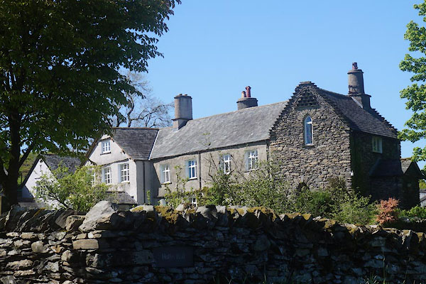 CDB81.jpg (taken 23.5.2015) 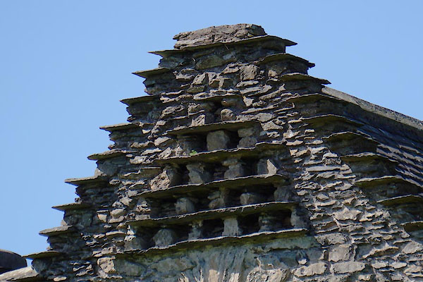 CDB82.jpg Pigeon holes. (taken 23.5.2015) |
||
|
|
||
| evidence:- | old map:- OS County Series (Wmd 33 14) placename:- Hollin Howe |
|
| source data:- | Maps, County Series maps of Great Britain, scales 6 and 25
inches to 1 mile, published by the Ordnance Survey, Southampton,
Hampshire, from about 1863 to 1948. |
|
|
|
||
| evidence:- | old map:- Jefferys 1770 (Wmd) placename:- Hollin Hall |
|
| source data:- | Map, 4 sheets, The County of Westmoreland, scale 1 inch to 1
mile, surveyed 1768, and engraved and published by Thomas
Jefferys, London, 1770. J5SD49NE.jpg "Hollin Hall" circle, labelled in italic lowercase text; settlement, farm, house, or hamlet? item:- National Library of Scotland : EME.s.47 Image © National Library of Scotland |
|
|
|
||
| evidence:- | old map:- Cary 1789 (edn 1805) placename:- Hollen Hall |
|
| source data:- | Map, uncoloured engraving, Westmoreland, scale about 2.5 miles
to 1 inch, by John Cary, London, 1789; edition 1805. CY24SD49.jpg "Hollen Hall" block/s, labelled in italic lowercase; house, or hamlet item:- JandMN : 129 Image © see bottom of page |
|
|
|
||
| evidence:- | old map:- Ford 1839 map placename:- Hollin Hall |
|
| source data:- | Map, uncoloured engraving, Map of the Lake District of
Cumberland, Westmoreland and Lancashire, scale about 3.5 miles
to 1 inch, published by Charles Thurnam, Carlisle, and by R
Groombridge, 5 Paternoster Row, London, 3rd edn 1843.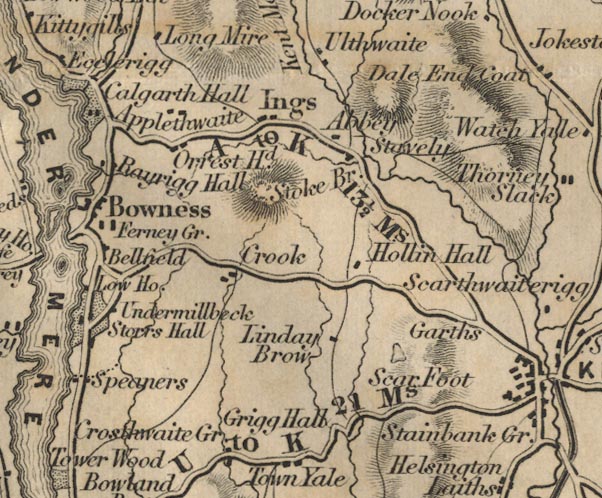 FD02SD49.jpg "Hollin Hall" item:- JandMN : 100.1 Image © see bottom of page |
|
|
|
||
| evidence:- | site plan:- Historical Monuments 1936 placename:- Hollin Howe |
|
| source data:- | Site plan, uncoloured lithograph, Nether Staveley Hollin How, ie Hollin Hall, Crook,
Westmorland, scale about 1 to 390, published by Royal Commission on Historical Monuments
England, London, 1936.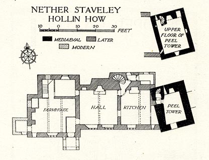 click to enlarge click to enlargeHMW130.jpg On p.218 of the Inventory of the Historical Monuments in Westmorland. printed, top "NETHER STAVELEY / HOLLIN HOW" RCHME no. Wmd, Nether Staveley 2 item:- Armitt Library : A745.131 Image © see bottom of page |
|
|
|
||
| evidence:- | database:- Listed Buildings 2010 placename:- Hollin Hall |
|
| source data:- | courtesy of English Heritage "HOLLIN HALL / / / CROOK / SOUTH LAKELAND / CUMBRIA / II / 76388 / SD4656696025" |
|
|
|
||
| evidence:- | database:- Listed Buildings 2010 |
|
| source data:- | courtesy of English Heritage "OUTBUILDING TO SOUTH WEST OF HOLLIN HALL / / / CROOK / SOUTH LAKELAND / CUMBRIA / II / 76389 / SD4653796018" |
|
|
|
||
| hearsay:- |
Originally a pele tower built by the Philipson Family, 1450 |
|
|
|
||
| notes:- |
tower |
|
| Perriam, D R &Robinson, J: 1998: Medieval Fortified Buildings of Cumbria: CWAAS::
ISBN 1 873124 23 6; plan and illustration |
||
|
|
||
 Lakes Guides menu.