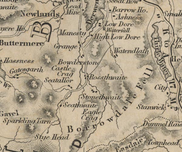
 Ford 1839 map NY21


|

|
|
|
gazetteer links places may or may not be labelled on the map |
||

|
-- Ashness -- "Ashness" |
|
|
|
-- Borrowdale Fells -- "Borrowdale Fell" |
|
|
|
-- Bowder Stone -- "Bowderstone" |
|
|
|
-- Castle Crag -- "Castle Crag" |
|
|
|
-- Eagle Crag -- "Eagle Crag" |
|
|
|
-- Grange -- "Grange" |
|
|
|
-- High Lodore -- "High Low Dore" |
|
|
|
-- Lodore Falls -- "Waterfall" |
|
|
|
-- Lodore -- "Low Dore" |
|
|
|
-- Manesty -- "Manesty" |
|
|
|
-- Newlands -- "Newlands" |
|
|
|
-- Rosthwaite -- "Rossthwaite" |
|
|
|
-- Seathwaite -- "Seathwaite" |
|
|
|
-- Seatoller -- "Seatallor" |
|
|
|
-- Sprinkling Tarn -- "Sprinkling Tarn" |
|
|
|
-- Stonethwaite -- "Stonethwaite" |
|
|
|
-- Sty Head -- "Sty Head" |
|
|
|
-- Watendlath Tarn |
|
|
|
-- Watendlath -- "Watendlath" |
|
|
civil parishes The area roughly includes parts of parishes:- St John's Castlerigg and Wythburn Buttermere Borrowdale Above Derwent Nether Wasdale Keswick Ennerdale and Kinniside Lakes |
||
|
|
||
|
|
Lakes Guides menu. | |