 Old Cumbria Gazetteer
 |
 |
|
| Borrowdale Fells, Borrowdale | ||
| Borrowdale Fells | ||
| civil parish:- | Borrowdale (formerly Cumberland) | |
| county:- | Cumbria | |
| locality type:- | hill | |
| locality type:- | fell | |
| coordinates:- | NY25191202 (etc etc) | |
| 1Km square:- | NY2512 | |
| 10Km square:- | NY21 | |
|
|
||
| evidence:- | old map:- OS County Series (Cmd 75 2) placename:- Borrowdale Fells |
|
| source data:- | Maps, County Series maps of Great Britain, scales 6 and 25
inches to 1 mile, published by the Ordnance Survey, Southampton,
Hampshire, from about 1863 to 1948. |
|
|
|
||
| evidence:- | old map:- Donald 1774 (Cmd) placename:- Borrowdale Fells |
|
| source data:- | Map, hand coloured engraving, 3x2 sheets, The County of Cumberland, scale about 1
inch to 1 mile, by Thomas Donald, engraved and published by Joseph Hodskinson, 29
Arundel Street, Strand, London, 1774.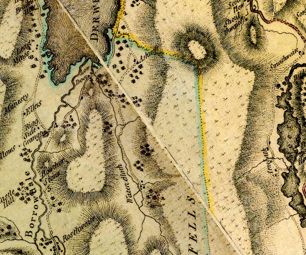 D4NY21NE.jpg 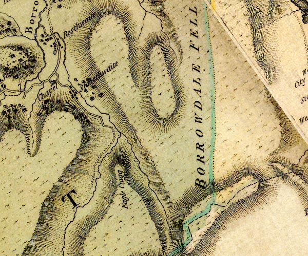 D4NY21SE.jpg "BORROWDALE FELLS" hill hachuring; a hill or mountain item:- Carlisle Library : Map 2 Images © Carlisle Library |
|
|
|
||
| evidence:- | old map:- West 1784 map placename:- Borrowdale Fells |
|
| source data:- | Map, hand coloured engraving, A Map of the Lakes in Cumberland,
Westmorland and Lancashire, scale about 3.5 miles to 1 inch,
engraved by Paas, 53 Holborn, London, about 1784.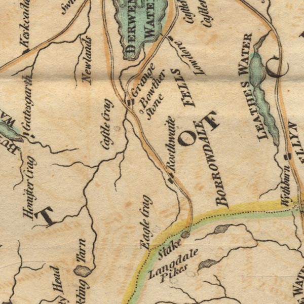 Ws02NY21.jpg "BORROWDALE FELLS" item:- Armitt Library : A1221.1 Image © see bottom of page |
|
|
|
||
| evidence:- | old map:- Cooke 1802 placename:- Borrowdale Fells |
|
| source data:- | Map, The Lakes, Westmorland and Cumberland, scale about 8.5
miles to 1 inch, engravedby Neele and Son, published by
Sherwood, Jones and Co, Paternoster Road, London, 1824. click to enlarge click to enlargeGRA1Lk.jpg "Borrowdale Fells" area of fells item:- Hampshire Museums : FA2000.62.5 Image © see bottom of page |
|
|
|
||
| evidence:- | old map:- Ford 1839 map placename:- Borrowdale Fell |
|
| source data:- | Map, uncoloured engraving, Map of the Lake District of
Cumberland, Westmoreland and Lancashire, scale about 3.5 miles
to 1 inch, published by Charles Thurnam, Carlisle, and by R
Groombridge, 5 Paternoster Row, London, 3rd edn 1843.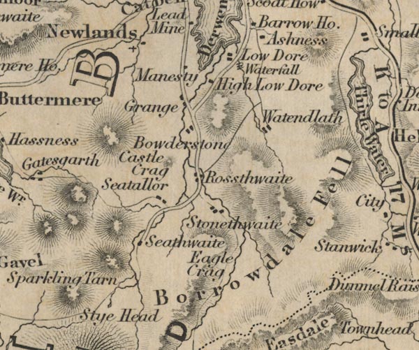 FD02NY21.jpg "Borrowdale Fell" Hill hachuring. item:- JandMN : 100.1 Image © see bottom of page |
|
|
|
||
| evidence:- | old painting:- |
|
| source data:- | Painting, watercolour, Lake District Fells, Borrowdale, Cumberland, by William James
Blacklock, 1850-58?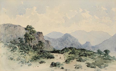 click to enlarge click to enlargePR0949.jpg A view of the Lake District fells above Borrowdale on a fine summer's day. A track winds through centre of composition across moorland interspersed with juniper bushes and birch trees. Beyond rise rocky fells receding into distance. Blacklock would have painted this watercolour on the spot. item:- Tullie House Museum : 1946.67.18 Image © Tullie House Museum |
|
|
|
||
| evidence:- | outline view:- Tattersall 1836 placename:- Borrowdale Fells |
|
| source data:- | Print, engraving, Thirlmere from Raysgap, Cumberland, drawn by George Tattersall,
engraved by W F Topham, published by Sherwood and Co, Paternoster Row, London, about
1836.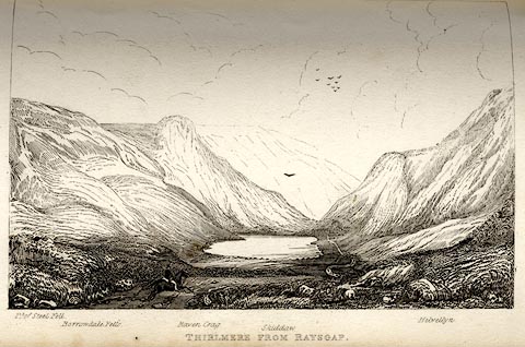 click to enlarge click to enlargeTAT117.jpg The print is captioned with mountain names and acts as an outline view. Tipped in opposite p.54 of The Lakes of England, by George Tattersall. printed at bottom:- "THIRLMERE FROM RAYSGAP." printed at bottom left to right:- "Pt. of Steel Fell. / Borrowdale Fells. / Raven Crag. / Skiddaw. / Helvellyn." item:- Armitt Library : A1204.18 Image © see bottom of page |
|
|
|
||
| evidence:- | old drawing:- Smith 1746 B placename:- Borrodale Fells |
|
| source data:- | Drawing, pencil and ink, Appearance of Mount Skiddow and the Borrodale Fells, in a
Survey of the Coast of Cumberland, by George Smith, 1746.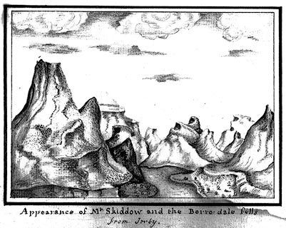 click to enlarge click to enlargeSM2104.jpg ms at bottom:- "Appearance of Mt. Skiddow and the Borro-dale fells / from Ireby." item:- Carlisle Library : 5.4 Image © Carlisle Library |
|
|
|
||
 Lakes Guides menu.