 Piggot 1826

|

|
|
|
map type:- Pigot 1826 |
|
|
|
Maps, Westmoreland, scale about 4.5 miles to 1 inch, and
Cumberland, scale about 7 miles to 1 inch, by James Pigot
and Co, engraved by Pigot and Co, Manchester, published by
James Pigot and Co, Basing Lane, London, 1826-27.
Westmorland has a vignette of Kendal Church; Cumberland, Carlisle Cathedral. Published in 'Pigot & Co.'s London and Provincial New Directory. For Feb. 1826-7. Third edition London and Manchester,' 1827. The 1st edition, 1822, had no maps. The 3rd edition is probably the first to have maps 'The Volume is embellished with a new series of Elegant Maps of the above-named Counties, engraved expressly for the Work, with highly-finished vignettes.' Published in 4th edition 1829, 5th edition 1832. The map was probably used for their 'British Atlas ...' published from 1828. Published in Slater's Royal National Commercial Directory of ... Westmorland, published by Isaac Slater, Manchester, Lancashire, 1869. Published in Slater's Royal National Commercial Directory of the Counties of Cumberland, Durham, Northumberland and Westmorland, published by Isaac Slater, Manchester, Lancashire, 1884. This version has the imprint removed, and, at the top 'PUBLISHED BY ISAAC SLATER' and at the bottom 'ROYAL NATIONAL DIRECTORY OFFICE, 41, KING ST. WEST, MANCHESTER.' The map has railways added. |
||
| see:- | Slater 1869 | |
| see:- | Slater 1884 | |
|
(map example JandMN (9))
|
||
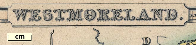
| map feature:- | title cartouche & plain cartouche & vignettes & compass rose & up is N & scale line & lat and long scales & table of wards & table of symbols & sea plain & coast form lines & rivers & lakes & parks & county & wards (hundreds) & settlements & roads & canals | |
| inscription:- |
printed title cartouche, top centre
WESTMORELAND. |
|
| inscription:- |
printed bottom centre and right
Published by Pigot & Co. 59, Fleet Street, London & 18 Fountain St. Manchester. / Engraved on Steel by Pigot & Co. Manchester |
|
| scale line:- | 10 miles = 57.9 mm | |
| scale:- | 1 to 280000 ? (1 to 277952 from scale line) | |
| wxh, map:- | 355x225mm | |
|
||
|
||
| references:- |
Pigot, James and Co: 1827: Pigot and Co's London and
Provincial New Directory: (London and Manchester) |
|
| sources:- |
Chubb 1927 (CCCXCIX) JandMN Collection Armitt Library Wordsworth Trust Collection Carlisle Library Maps Kendal Library Maps |
|
| items seen (illustrated items in bold):- | ||

|
Armitt Library : ALMC2008.14.39 -- map -- Westmoreland | |
|
|
Armitt Library : ALMC2008.14.40 -- map -- Westmoreland | |
|
|
Carlisle Library : Map 147 -- map -- Cumberland | |
|
|
Carlisle Library : Map 150 -- map -- Cumberland | |
|
|
Carlisle Library : Map 153 -- map -- Cumberland | |
|
|
Carlisle Library : Map 186 -- map -- Westmoreland | |
|
|
Carlisle Library : Map 194 -- map -- Westmoreland | |
|
|
Carlisle Library : Map 197 -- map -- Westmoreland | |
|
|
Dove Cottage : 2007.38.29 -- map -- Westmoreland | |
|
|
Dove Cottage : 2007.38.30 -- map -- Westmoreland | |
|
|
JandMN (9) -- map -- Westmoreland | |
|
|
Kendal Library : Map 92 -- map -- Westmoreland | |
|
|
Kendal Library : Map 93 -- map -- Westmoreland | |