 Pigot 1826

|

|
|
|
item:- JandMN (9) image:- © see bottom of page |
click to enlarge |
|
|
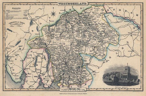
Map, Westmoreland ie Westmorland, scale about 4.5 miles
to 1 inch, by James Pigot and Co, Basing Lane, London,
1826-27.
Lower right there is a vignette of Kendal Church. Engraved by Pigot and Co, Manchester; published in Pigot and Co's British Atlas of the Counties of England. |
||

|
Pigot 1826 | |
| map feature:- | plain cartouche & vignettes & compass rose & up is N & scale line & lat and long scales & table of wards (hundreds) & table of symbols & sea plain & coast form lines & rivers & lakes & parks & county & wards (hundreds) & settlements & roads & canals | |
| inscription:- |
printed title cartouche, top centre
WESTMORELAND. |
|
| inscription:- |
printed bottom centre and right
Published by Pigot & Co. 59, Fleet Street, London & 18 Fountain St. Manchester. / Engraved on Steel by Pigot & Co. Manchester |
|
| scale line:- | 10 miles = 57.9 mm | |
| scale:- | 1 to 280000 ? (1 to 277952 from scale line) | |
| wxh, map:- | 355x225mm | |