 Pigot 1826

|

|
|
|
item:- Dove Cottage : 2007.38.30 image:- © see bottom of page |
click to enlarge |
|
|
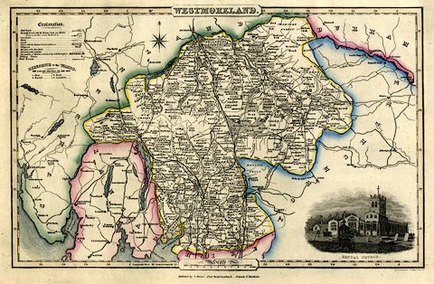
Map, hand coloured engraving, Westmoreland ie
Westmorland, scale about 4.5 miles to 1 inch, by James Pigot
and Co, 1826-27, published by Isaac Slater, Fleet Street,
London, and Fountain Street, Manchester, about 1860?
Lower right there is a vignette of Kendal Church. Railways have been added to the map - Lancaster and Carlisle Railway, opened 1846; Kendal and Windermere Railway, opened 1847, drawn through to Ambleside as imagined but not built; Low Gill and Ingleton branch, opened 1861, but originally proposed in as part of the North Western Railway in 1846; and the South Durham and Lancashire Union Railway, authorised 1857 opened 1861; (remember that railways are planned in advance of their authorisation, in advance of their opening). |
||

|
Pigot 1826 | |
| map feature:- | plain cartouche & vignettes & compass rose & up is N & scale line & lat and long scales (rectangular projection?) & table of wards (hundreds) & table of symbols & sea plain & coast form lines & rivers & lakes & woods & forests & parks & county & wards (hundreds) & settlements & roads & canals & railways | |
| inscription:- |
printed title cartouche, top centre
WESTMORELAND. fancy font |
|
| inscription:- |
printed bottom centre and right
Published by Pigot & Co. 1 Basing Lane London & 18 Fountain St. Manchester. / Engraved on Steel by Pigot & Son. Manchester |
|
| inscription:- |
printed above and after scale line
Scale / Miles |
|
| scale line:- | 10 miles = 57.4 mm | |
| scale:- | 1 to 280000 ? (1 to 280374 from scale line assuming a statute mile) | |
| wxh, sheet:- | 41x29cm | |
| wxh, plate:- | 376x252mm | |
| wxh, map:- | 353x224mm | |