 Jefferys 1775

|

|
|
|
map type:- Jefferys 1775 |
|
|
|
Road strip maps with sections in Westmorland, Cumberland
etc, scales about 1.5 miles to 1 inch? derived from maps by
Ogilby, 1675, and by John Senex, 1719 and 1757, by Thomas
Jeffery, London, 1775.
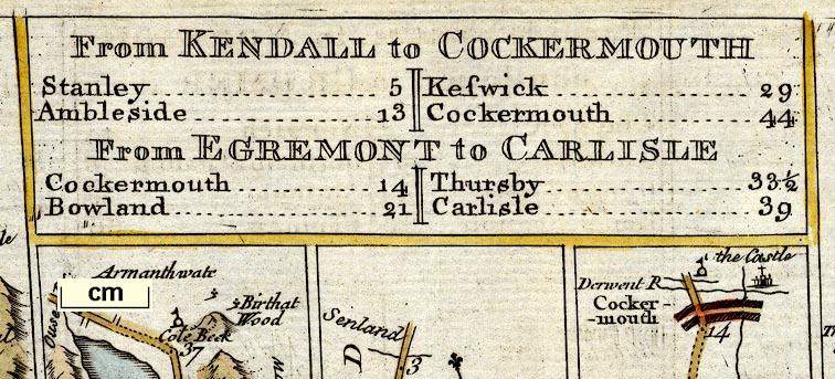
Published in 'Jefferys's Itinerary; or Travellers Companion, Through England, Wales, and Part of Scotland, Containing All the Direct and Principal Cross Roads; with the Addition of every New Road. Carefully collected from all the actual Surveys hitherto published. Improved with many thousand names of places more than are in any similar publication. To which are added Copious Indexes to all the Roads and Places mentioned in the work, with their exact Distance from London. London, Printed for R. Sayer and J. Bennett, Map and Print Sellers, No.53, Fleet-Street. MDCCLXXV.' ie 1775. The maps are newly engraved, though based on Senex's road 1757, which ultimately derive from Ogilby's work, 1675. The strips are rectangular, no longer scrolls, with a plain rectangular title cartouche. The road book has indexes to places, towns, and roads, a general map of post roads. The maps concerning Westmorland are the same numbering as the plates of Senex 1757, described more fully under Senex 1719:- The plates that concern Westmorland, Cumberland etc, now Cumbria are 39, 67, 82, 95 (these were originally 36,62, 86, 96 in Senex 1719). Plate 39 in the London to Carlisle road - from Garstang, through Lancaster, Carnford, Lancashire; then Burton, Kendal, Shap, Westmorland; and Penrith to Carlisle, Cumberland. Plate 67 Road from Carlisle to Barwick - from Carlisle, Cumberland; then Jedboro, Kelso, Scotland; to Berwick, Northumberland. Plate 82 Roads from Kendal to Cockermouth and Egremont to Carlisle - from Kendal, through Stanley, Ambleside, Westmorland; then Keswick, to Cockermouth, Cumberland AND from Egrimond through Cockermouthto Carlisle, Cumberland. Plate 95 Road from Tinmouth to Carlisle - from Tinmouth through Newcastle, Hexham, Haltwesell, Northumberland; then Corby to Carlisle, Cumberland. Published in 'The Roads of England Delineated; or, Ogilby's Survey, Revised, Improved, and Reduced to a Size portable for the Pocket, by John Senex, F.R.S. Being an Actual Survey of All the Principal Roads of England and Wales; Distinctly Laid Down on One Hundred and one Copper-Plates; ... With the Additions of some Roads newly drawn, which were omitted by Mr. Ogilby, and several necessary Corrections made in Others; together with a great Number of explanatory References, by which this Edition of the Roads is rendered of more general use to Travellers.' 1775. The 1775 reprint has exactly the same map. The maps are published earlier, with title cartouches in French in 'The Roads through England, or Ogilby's Survey Revised, Improved, and Reduced by Senex ...' by Le Rouge, Augustin Street, Paris, France, 1769. And by Desnos, St James Street, Paris, France about the same time. |
||

|
Ogilby 1675 | |
|
|
Senex 1719-57 | |
|
|
Kitchin 1767 | |
|
(map example Dove Cottage : 2007.38.83)
|
||
| map feature:- | title cartouche & up is destination & rivers & lakes & relief & hill hachuring & parks & county & settlements & roads & road distances & table of distances | |
| inscription:- |
printed bottom right
Publish'd as the Act directs by R. Sayer & J. Bennett 16 Janry. 1775. |
|
| wxh, sheet:- | 24x18.5cm | |
| wxh, plate:- | 216x161mm | |
| wxh, map:- | 204x150mm | |
| references:- |
Jefferys, Thomas: 1775: Jefferys's Itinerary & Travellers
Companion: Sayer, Robert & Bennett, John (London) Senex, John: 1775: Roads of England Delineated, The & Ogilby's Survey, Revised, Improved, and Reduced: (London) : 1769: Roads through England, The: le Rouge (Paris, France) |
|
| sources:- |
Chubb 1927 (CXLIV) Wordsworth Trust Collection Armitt Library David Webb Collection |
|
| items seen (illustrated items in bold):- | ||
|
|
Armitt Library : ALMC2008.14.106 -- strip map (pl.82) -- From Kendall to Cockermouth -- From Egremont to Carlisle | |
|
|
Dove Cottage : 2007.38.83 -- strip map (pl.81/82) -- From Kendal to Cockermouth -- From Egremont to Carlisle -- From Ipswich to Norwich continued to Cromer | |