 Jefferys 1775

|

|
|
|
item:- Dove Cottage : 2007.38.83 image:- © see bottom of page |
click to enlarge |
|
|
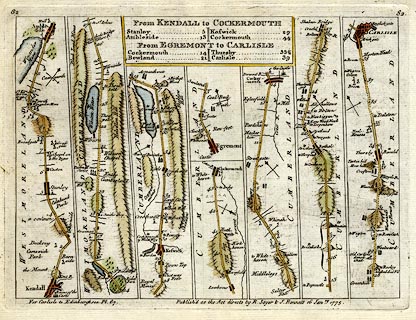
Road strip map, hand coloured engraving, From Kendal to
Cockermouth, From Egremont to Carlisle, and uncoloured on
reverse, From Ipswich to Norwich continued to Cromer, scales
about 1.5 miles to 1 inch? by Thomas Jeffery, published by R
Sayer and J Bennett, 53 Fleet Street, London, 1775.
From Jefferys's Itinerary; or Travellers Companion, Through England, Wales, and Part of Scotland. Pl.82 from Kendal to Cockermouth and Egremont to Carlisle - from Kendal, through Stanley, Ambleside, Westmorland; then Keswick, to Cockermouth, Cumberland AND from Egrimond through Cockermouthto Carlisle, Cumberland. Pl.81 from Ipswich to Norwich continued to Cromer - from Ipswich, Suffolk; through Osmondston, Norwich, to Cromer, Norfolk. The maps are derived from maps by Ogilby 1675, and by John Senex 1719 and 1757, etc. |
||

|
Jefferys 1775 | |
| map feature:- | plain cartouche & up is destination & rivers & lakes & relief & hill hachuring & parks & county & settlements & roads & road distances & table of distances | |
| inscription:- |
printed bottom right
Publish'd as the Act directs by R. Sayer & J. Bennett 16 Janry. 1775. |
|
| wxh, sheet:- | 24x18.5cm | |
| wxh, plate:- | 216x161mm | |
| wxh, map:- | 204x150mm | |