 Kitchin's Post Chaise Companion

|

|
|
|
map type:- Kitchin 1767 |
|
|
|
Road book, Kitchin's Post Chaise Companion, including
road strip map sections in Westmorland, Cumberland etc,
scales about 2.5 miles to 1 inch, derived from maps by
Ogilby, 1675, by John Senex, 1719 and 1757, then amended by
Thomas Kitchin, London, 1767, published also in France;
published 1767-1780?
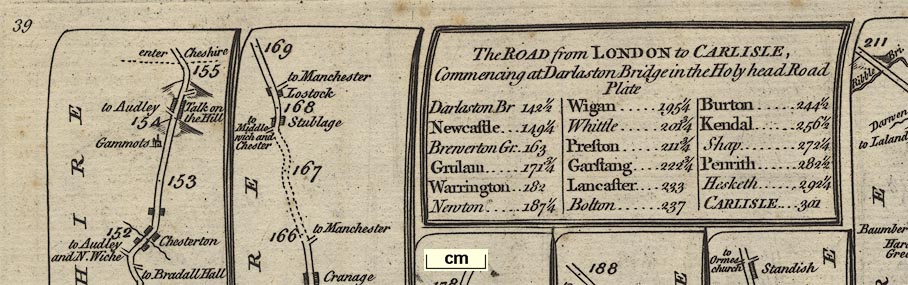
Published in 'KITCHIN's Post-Chaise Companion, THROUGH ENGLAND and WALES; CONTAINING All the Ancient and New Additional ROADS, WITH Every Topographical Detail relating thereto. By THOMAS KITCHIN, For the Use of TRAVELLERS, on One Hundred and Three Copper Plates. London: Printed for ROBERT SAYER, at No 53, in Fleet-street; JOHN BOWLES, at No , in Cornhill; CARRINGTON BOWLES, at No 69, in St. Paul's Church-Yard; 1767. ...' The maps in the road book are the strip maps of Senex 1757, with considerable alterations, they should be considered new maps; the road book includes title page, lists of towns, and a general map of Great Britain; its price was 7s6d, size is 9 x 7 1/2 ins. The plates concerning Westmorland, Cumberland etc now Cumbria are - 39, 40, 68, 84 and 97. (NB the pagination is different from the Senex 1757 strip maps) Plate 39 from Darlaston Bridge, through Newcastle under Line, Staffordshire; then Holmes Chappel, Cheshire, Warrington, Wigan, Preston, to Garstang, Lancashire. Plate 40 from Garstang to Lancaster, Lancashire; then Burton, Kendal, Shap, Westmoreland now Cumbria; Penrith to Carlisle, Cumberland now Cumbria; the scroll on the right describes some additional roads - from Whitehaven to London, through Hawkshead, Cartmell and Lancashire; AND from Whitehaven to Carlisle running into the Egremont to Carlisle road on plate 84; AND a new military road from Newcastle to Carlisle different from that on plate 97. Plate 68 from Carlisle, Cumberland now Cumbria, through Jedburgh and Kelso, Borders, Scotland to Berwick, Northumberland. Plate 84 from Kendal through Stanley ie Staveley and Ambleside, Westmorland now Cumbria; then Keswick to Cockermouth, Cumberland now Cumbria; AND from Egremont to Carlisle, Cumberland now Cumbria. Plate 97 from Tinmouth, through Newcastle, Corbridge, Hexham, Northumberland; then Corby to Carlisle, Cumberland now Cumbria. Published in 'Kitchin's Post-Chaise Companion ... London: Printed for and sold by Carington Bowles, at his Map and Print Warehouse, No.69, in St. Paul's Church-Yard,' 1770. The 1770 edition has no changes to the maps. Published in 'Nouvel Atlas D'Angleterre Divise En ses 52 Comtea Avec toutes les Routes Levees Topographiquement par ordre de S. M. Britannique et les Plans des Villes et Ports de ce Royaume. A Paris, Chez le Sieur Desnos Ingenieur Geographe pour les Globes et St. Jacques 1767.' The maps have titles translated into French; the road book has town plans and views at the back; size is about 10 x 14 ins. Published in an edition, 1780. |
||

|
Ogilby 1675 | |
|
|
Jefferys 1775 | |
|
(strip map example HMCMS:FA1999.138.39)
|
||
| map feature:- | title cartouche & table of distances & north point & up is destination & county & settlements & roads & rivers & distances from London & relief & hillocks & woods & parks | |
| inscription:- |
printed title cartouche
The ROAD from LONDON to CARLISLE, / Commencing at Darlaston Bridge in the Holy head Road / Plate / ... table of distances |
|
| wxh, page:- | 23x18cm | |
| wxh, map:- | 20x15cm (roughly) | |
| scale:- | 1 to 150000 ? (average of three estimates from marked miles, 2.5 miles to 1 inch assuming a statute mile) | |
| references:- |
Kitchin, Thomas: 1767: Kitchin's Post-Chaise Companion:
Bowles, John (Cornhill, London) & Bowles, Carington & Sayer,
Robert (London) Kitchin, Thomas: 1770: Kitchin's Post-Chaise Companion: Bowles, Carington (London) Kitchin, Thomas: 1767: Nouvel Atlas D'Angleterre: Desnos (Paris, France) Norgate, Martin: 2001: Kitchin's Post Chaise Companion, 1767: Hampshire CC Museums Service:: ISBN 1 85975 493 7; facsimile reproduction |
|
| sources:- |
Chubb 1927 (CXLI) HMCMS Map Collection Fordham 1924 |
|
| items seen (illustrated items in bold):- | ||
|
|
Armitt Library : ALMC2008.14.105 -- strip map (pl.84/85) -- Road from Kendall to Cockermouth -- Road from Egremont to Carlisle -- Road from Kings Lynn to Harwich | |
|
|
Hampshire Museums : FA1999.138 -- road book -- Kitchin's Post Chaise Companion | |
|
|
Hampshire Museums : FA1999.138.0 -- road map -- General Map of the ... Roads in England and Wales -- General Map of the Direct and Principal cross Roads in England and Wales -- Kitchin's Post Chaise Companion | |
|
|
Hampshire Museums : FA1999.138.39 -- strip map (pl.39) -- Road from London to Carlisle -- Kitchin's Post Chaise Companion | |
|
|
Hampshire Museums : FA1999.138.40 -- strip map (pl.40) -- Road from London to Carlisle -- Kitchin's Post Chaise Companion | |
|
|
Hampshire Museums : FA1999.138.68 -- strip map (pl.68) -- Road from Carlisle to Berwick -- Kitchin's Post Chaise Companion | |
|
|
Hampshire Museums : FA1999.138.84 -- strip map (pl.84) -- Road from Kendal to Cockermouth -- Road from Egremont to Carlisle -- Kitchin's Post Chaise Companion | |
|
|
Hampshire Museums : FA1999.138.97 -- strip map (pl.97) -- Road from Tinmouth to Carlisle -- Kitchin's Post Chaise Companion | |