 Kitchin 1767

|

|
|
|
item:- Armitt Library : ALMC2008.14.105 image:- © see bottom of page |
click to enlarge |
|
|
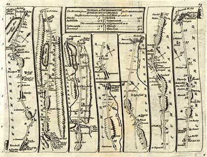
Road strip map, uncoloured engraving, The Road from
Kendall to Cockermouth, and The Road from Egremont to
Carlisle, in Westmorland and Cumberland, and on the reverse
the road from Kings Lynn, Norfolk to Harwich, Essex, scales
about 3 miles to 1 inch, by Thomas Kitchin, published by
Robert Sayer, 53 Fleet Street, John Bowles, Cornhill, and
Carington Bowles, St Paul's Church Yard, London, 1767.
Pl.84 in Kitchin's Post Chaise Companion - from Kendall through Ambleside, Westmorland; then Keswick, to Cockermouth, Cumberland; AND from Egremont, through Cockermouth, to Carlisle, Cumberland. Plate 85, the reverse, is the Road from Kings Lynn to Harwich, Essex - from Kings Lynn, through Swafham, Thetford, Norfolk; Ixworth, Stowmarket, Ipswich, Suffolk; across a ferry to Harwich, Essex. The maps are derived from maps by Ogilby 1675, and by John Senex 1719 and 1757, etc. |
||

|
Kitchin 1767 | |
| map feature:- | plain cartouche & north point & up is destination & rivers & lakes & woods & parks & county & settlements & roads & road distances | |
| inscription:- |
printed title cartouche at top
The ROADS from / KENDALL to COCKERMOUTH / EGREMONT to CARLISLE / in CUMBERLAND / The first commencing at Kendall Plate 40 ... / The secooond commencing at Egremont ... |
|
| wxh, page:- | 24x18cm | |
| wxh, map:- | 21x15cm (roughly) | |
| scale:- | 1 to 190000 ? (estimated) | |