 Kitchin 1767

|

|
|
|
item:- Hampshire Museums : FA1999.138.40 image:- © see bottom of page |
click to enlarge |
|
|
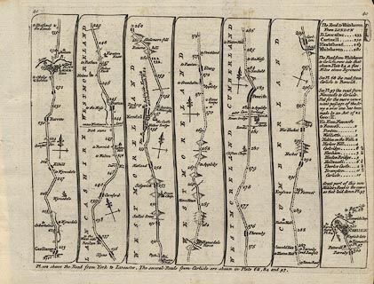
Road strip map, uncoloured engraving, The Road from
London to Carlisle, in Kitchin's Post Chaise Companion, by
Thomas Kitchin, published by Robert Sayer, 53 Fleet Street,
John Bowles, Cornhill, and Carington Bowles, St Paul's
Church Yard, London, 1767.
Pl.40 from Garstang to Lancaster, Lancashire; then Burton, Kendal, Shap, Westmoreland; Penrith to Carlisle, Cumberland; scale about 3 miles to 1 inch. The scroll on the right describes some additional roads - from Whitehaven to London, through Hawkshead, Cartmell and Lancashire; AND from Whitehaven to Carlisle running into the Egremont to Carlisle road on plate 84; AND a new military road from Newcastle to Carlisle different from that on plate 97. |
||

|
Kitchin 1767 | |
| wxh, page:- | 23x18cm | |
| wxh, map:- | 20x15cm (roughly) | |
| scale:- | 1 to 190000 ? (estimated) | |
|
|
notes | |