 Kitchin 1767

|

|
|

|
back to object record | |
| Road Book | ||
|
Title Page:-
|
||
|
KITCHIN's Post-Chaise Companion, THROUGH ENGLAND and WALES;
CONTAINING All the Ancient and New Additional ROADS, WITH
Every Topographical Detail relating thereto. By THOMAS
KITCHIN, For the Use of TRAVELLERS, on One Hundred and Three
Copper Plates.
|
||
|
LONDON: Printed for ROBERT SAYER, at No 53, in Fleet-street;
JOHN BOWLES, at No, in Cornhill; and CARINGTON BOWLES, at No
69, in St. Paul's Church-Yard. 1767. Price 7s. 6d.
|
||
|
|
||
| general map |
The road book has an unnumbered plate:-
A General MAP of the Direct & Principal Cross ROADS in ENGLAND and WALES; extended to Edinburgh in SCOTLAND. The map is an index to the road book, the relevant plate number is given for each route on the map. |
|
|
|
||
|
index of places
table of distances |
There is-
An INDEX of all the Cities, Market-Towns, and principal Villages, on the Direct Roads; shewing their respective Distance from London in measured Miles; in what County situate, and the Page in which they are to be found. These Distances are measured from the STANDARD in CORNHILL, near the ROYAL EXCHANGE. The index is formatted in four columns:- Page / Towns. / County. / Miles with entries on the pattern:- 40 / Kendal / Westmorl. / 256 1/2 There is also a:- A TABLE of the CROSS ROADS. Shewing the measured Distances from one Town to another, and the Total Distance from the Town where the Road begins, to the Town at the End of it. The table is formatted in three columns:- P. / Towns. / M. with entries after a heading, on the pattern:- 24 / KENDAL to COCKERMOUTH / 44 / viz. to / / Stanley / 5 / Ambleside / 8 1/4 / Keswick / 16 / Cockermouth / 14 1/2 |
|
| MAP FEATURES | ||
|
Where possible these remarks refer to segments of road in
Westmorland and Cumberland; the rest of the road book has
been explored less thoroughly.
|
||
|
|
||
|
title cartouche
plain cartouche table of distances distances from London distances from start |
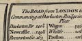
A plate that begins a route has a plain title cartouche upper centre, the sides curved to fit within the scrolls of the route maps. The title of the route is followed by a table of distances, eg plate 39:- The ROAD from LONDON to CARLISLE, Commencing at Darlaston Bridge in the Holyhead Road Plate then, tabulated:- Darlaston Br ... 142 1/2 / ... / Lancaster ... 223 / Bolton 237 / Burton ... 244 1/2 / Kendal 256 1/2 / Shap 272 1/4 / Penrith 282 1/2 / Hesketh 292 1/4 / CARLISLE 301 |
|
|
|
||
|
orientation
north point up is destination |
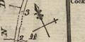
The orientation of each scroll is indicated by a north point; N-S line, E-W cross line, North marked by a fleur de lys or by a spear point, East marked by a cross. The orientation of the strip maps is arranged so that up is towards the destination; as you journey from town you look up to what is before you. Where a route terminates and a new route is started on a scroll there will be a separate north point for each route segment. Also, where a route bends so much that it will not fit within a scroll the orientation of different segments will be indicated by separate north points. This happens on plate 97 scroll 6, either side of Bampton - though the exact break of route is not shown. While the general bearing of the route can be taken from the north point the actual direction of a stretch of road is not so certain. The wiggles in the road are probably compressed sideways to fit within the scrolls. |
|
|
|
||
| scale |
The maps have no declared scale. Road distances are
marked by a dot in the road at one mile intervals, labelled
at the side. From these marks it is apparent that there is
no fixed scale; even within one scroll the spacing of marks
varies, and on an adjacent scroll the spacing might be very
different.
The map scales are about:- 1 to 160000 2.5 miles to 1 inch |
|
|
|
||
|
rivers
bridges |
Rivers are drawn by a double line with stream lines, or
by a wiggly line crossing a road. Larger rivers might be
labelled, eg:-
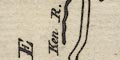
Ken R. Eden R. Many rills are shown, which may or may not reflect ground truth. Bridges are implied where a road crosses and interrupts a stream, but I would not rely on the presence of a bridge where suggested, nor the lack of a bridge where not. A few bridges are labelled, eg:- 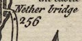
Nether bridge Emon bridge And a bridge name might be the same as a settlement name. |
|
|
|
||
|
relief
hillocks |
Relief along the road is indicated by hillocks. Where
these are engraved under the route they probably imply an
ascent or descent. A line of hillocks suggests a ridge or a
long slope. Hillocks beside the road might be drawn to
suggest mountainous scenery. Very few hills are labelled,
eg:-
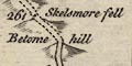
Skelsmore fell [Skelsmergh Fell] Betome hill north of Kendal, and:- Grasmere Hill |
|
|
|
||
| lakes |
Lakes are only shown if they are near a route. They might
be drawn in outline, the shore shaded, and perhaps
labelled:-
Wiburn Water [Thirlmere] Winander Mere Water or might be recognised, eg:- Bassenthwaite Lake Rydal Water |
|
|
|
||
|
woods
trees |
A little woodland is indicated by tree symbols, and might
be labelled. For example, three tree symbols are
labelled:-
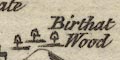
Birthat Wood near Armathwaite on the road to Cockermouth. |
|
|
|
||
| parks |
A park is drawn by an outline with a design meant to
suggest a paling fence, perhaps containing a few trees,
perhaps labelled, eg:-
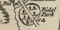
Ridal Park |
|
|
|
||
| county |
A county boundary is a dotted line, usually labelled
as:-
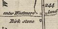
enter Westmoreland just after the Birk Stone on the road from Lancaster, plate 40 mile 243. The county through which a route is situated is labelled along the side of the scroll, eg:- WESTMORELAND |
|
|
|
||
|
settlements
street map |
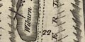
On a route, settlements are drawn with blocks or groups
of blocks, perhaps laid out in streets in larger towns; off
the route a settlement might be marked by a drawing of a
church; settlements are differentiated by style of
labelling.
The notes below come from a quick look through the plates; the maps are not interesting enough to deserve a detailed study at this phase of the Old Hampshire Maps project. |
|
| cities |
group of blocks or shaded areas on a street plan, town
walls and bastions, castle, labelled in upright block
caps:-
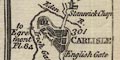
CARLISLE Two gates are labelled:- Irish Gate English Gate and the rivers are bridges make up a miniature plan of the city. |
|
| towns |
group of blocks; labelled in upright lowercase text,
eg:-
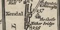
Kendal which has a street plan, with river, bridges, and castle. Also:- Penrith which is drawn by a long curved street with houses on each side. |
|
|
villages
hamlets |
small group of blocks, perhaps a church; labelled in
italic lowercase text, eg:-
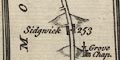
Sidgwick 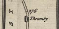
Thrumby Off the road a village might be shown by a church, for example at:- Barnside [Burneside] Off the road a hamlet might be shown by a drawing of a house or houses. These might be face on, as at:- 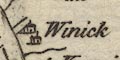
Winick [plate 84 mile 6] or a row of houses gable end on, as at:- 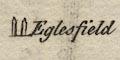
Eaglesfield [plate 84 mile 9] |
|
|
houses
castles |
An individual house or castle might be drawn and
labelled, eg:-
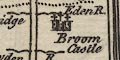
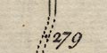
Broom Castle [plate 40 mile 281] Lampley Hall [plate 84 mile 6] At Kendal there are the:- Ruins of the Castle |
|
|
|
||
|
roads
distances from London distances from start |
The road is drawn up the middle of each scroll by a double line; solid or dotted for fenced or unfenced. The route segment starts at the lower left of each plate, bottom of the left scroll, runs to the top of the scroll, picks up at the bottom of the next scroll, and so on. The road is the focus of the mapping, few topographical details are shown off the road. Distances from London, or other starting place, are marked each mile by a dot in the road, labelled in arabic numerals. As already noted, these are not evenly spaced, and not the same spacing on each scroll. Junctions are clearly drawn, and sometimes labelled, eg:- 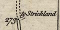
to Strickland [plate 40 mile 273] An alternative route might be indicated at a junction, as:- 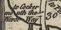
to Cockermouth the Worst Way at plate 84 mile 30, the turning for the Whinlatter Pass. Where the route joins another route in the road book the labelling is helps. For example, at Carlisle there are:- 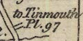
to Tinmouth Pl.97 to Egremont Pl.84 to Berwick Pl.68 The information might be repeated at the bottom of the plate, thus for plate 40:- Pl.102 shews the Road from York to Lancaster, The several Roads from Carlisle are shewn in Plate 68, 84 and 97. |
|
|
|
||
| itineraries |
A route not mapped in the set of plates might be
described in an itinerary. For example, on plate 40, in
spare space after Carlisle is reached:-
The Road from Whitehaven From LONDON / To Lancaster ... 233 / Cartmell ... 250 / Hawkshead ... 263 / Whitehaven ... 281 The Road from Whitehaven to Carlisle runs into that shewn Plate 84 a few Miles above Egremont ... See Pl.97 the road from Newcastle to Carlisle. But for the more convenient passage of the Army a new one has been made by an Act of 24 Geo: II. Viz. From Newcastle / to Benwell ... 2 / Denton ... 1 / Wallbottle ... 2 / Heddon on the Wall ... 2 / Harlow Hill ... 4 / Corbridge ... 8 3/4 / Hexham ... 3 1/4 / Headon Bridge ... 5 / Haltwesell ... 6 1/2 / Thurloe Castle ... 4 1/2 / Brampton ... 11 3/4 / Carlisle ... 10 Great part of this new Military Road is the same as that laid down Pl.97. |
|
|
|
||
| miscellaneous |
Thomas Kitchin's road strip maps show incidental features
beside the road, what the tourist might or should notice,
perhaps.
|
|
|
|
||
| stones |
In Lancashire, just before the boundary into Westmorland,
is the:-
Birk Stone This is useful evidence for understanding the old road taken by this route which is now nothing more than a farm track. |
|
|
|
||
|
antiquities
stone circles |
A scatter of three stones is labelled:-
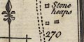
Stone heaps plate 40 mile 270 before Shap. This might be the stone circle about there. |
|
|
|
||
|
antiquities
roman sites roman wall |
Plate 97 mile 53 has:-
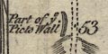
Part of ye Picts Wall drawn by a wall on the left. |
|
|
|
||
| smithies |
Plate 84 mile 18 has:-
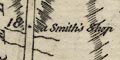
a Smith's shop presumably labelled as there is no facility nearby in a village? |
|
Lakes Guides menu.