 Jefferys 1775

|

|
|
|
item:- Armitt Library : ALMC2008.14.106 image:- © see bottom of page |
click to enlarge |
|
|
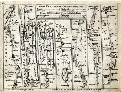
Road strip map, uncoloured engraving, From Kendall to
Cockermouth, and From Egremont to Carlisle, in Westmorland
and Cumberland, scales about 1.5 miles to 1 inch? by Thomas
Jeffery, published by R Sayer and J Bennett, 53 Fleet
Street, London, 1775.
Pl.82 in Jefferys's Itinerary; or Travellers Companion, Through England, Wales, and Part of Scotland - from Kendall, through Ambleside, Westmorland; then Keswick, to Cockermouth, Cumberland AND from Egremont through Cockermouth, to Carlisle, Cumberland. The reverse is blank. The map is derived from those by Ogilby 1675, and by John Senex 1719 and 1757, etc. |
||

|
Jefferys 1775 | |
| map feature:- | plain cartouche & up is destination & rivers & lakes & relief & hill hachuring & parks & county & settlements & roads & road distances & table of distances | |
| inscription:- |
printed bottom right
Publish'd as the Act directs by R. Sayer & J. Bennett 16 Janry. 1775. |
|
| wxh, sheet:- | 24.5x18cm | |
| wxh, plate:- | 215x160mm | |
| wxh, map:- | 204x150mm | |