 Badeslade 1742

|

|
|
|
map type:- Badeslade 1742 |
|
|
|
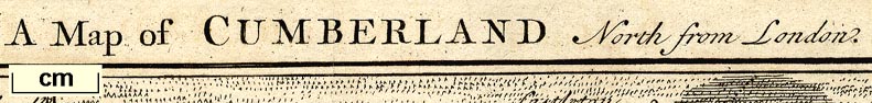
Maps, Westmorland North from London, scale about 10 miles
to 1 inch, and Cumberland North from London, scale about 11
miles to 1 inch, with descriptive text, by Thomas Badeslade,
London, engraved and published by William Henry Toms, Union
Court, Holborn, London, 1742; published 1742-49.
There are also maps of South Britain, England and Wales, scales about 70 miles to 1 inch, showing Great Roads from London, Cross Roads from One Great Town to another, the Sea Coast of England and Wales, and England and Wales Divided into Counties, each of which includes Westmorland and Cumberland etc. Published in 'Chorographia Britanniae or A Set of Maps of all the Counties of England and Wales: to which is prefix'd the following general Maps, vix. I. An Accurate Chart of the Sea Coast, exhibiting all the Royal Docks, Fortifications, harbours, sands &c. II. A Map of England and Wales, as divided into Counties, with the Names of all the Cities and County Towns; and the Length, Breadth, and Superficial Content of the Whole, and each County separately. III. A Map of the great Roads from London, to all parts of South Britain; with Tables shewing the distance of each City, and Town upon the Road, from the Metropolis, both in Computed and Measured Miles. IV. A Map of all the Cross Roads, from one great Town to another , with the distances from Town to Town, both by Computation and Measure. With the particular Map of each County, is an Account of all the Cities, Boroughs, Market Towns, Parishes, and Rivers therein: the Number of Members it sends to Parliament, the Market and Fair days, ... To the Whole is added an Alphabetical Index, of all the Cities, Boroughs, & Market Towns, properly distinguish'd from each other, and in what County they are situate.' 'This Collection (conveying a more comprehensive Idea of South Britain than any thing hitherto publish'd) was first Drawn and compiled into a Pocket Book by Order and for the Use of his late Majesty King George I. By Thos. Badeslade Surveyor and Engineer, and now neatly Engrav'd by Will. Henry Toms. Printed for and sold by W. H. Toms Engraver, in Union Court, near Hatton Garden, Holborn, 1742.' The atlas has a title page, dedication with royal coat of arms, general maps, 5 pages of text; its size is 7 3/4 x 6 1/2 ins; the maps have text at the left, blank on reverse, Westmorland is plate ?41; the maps are said to be based on Moll's maps 1724 and were presumably drawn before the death of George I, 1727. Published in another edition 1742 with some changes, village names and additional roads; the edition is rare? Published in another edition 1742 same as above but the imprint date on the map changed to 'Sept. 29 1742'. Published in a second edition '... first Drawn and compiled into a Pocket Book by Order and for the Use of his late majesty King George I. for his intended Tour thro' England & Wales. ... The Second Edition to which is added the Rates for Hackney Coaches, Chairmen and Watermen with the Measured Distances taken by Order of the Commissioners. Printed for C. Hitch in Paternoster Row, and W. H. Toms Engraver in Union Court Holbourn 1745. Price in Sheets 5s. Bd. 6s. & Colour'd 12s.' The map in the 1745 edition might be the 1741 or 1742 version. Published in another edition 'Chorographia Britanniae ... Published According to Act of Parliament. Sold by J. Clark Bookseller at ye Golden Ball, in St. Paul's Church Yard, C. Hitch Bookseller in Pater Noster Row, & by W. H. Toms Engraver, in Union Court Holbourne, Price in Sheets 5s. Bound 6s. Bound & Coloured 12s.' about 1746. The map in the 1746? edition is unchanged. Published in another edition 'Chorographia Britanniae ... Sold by C. Hitch Bookseller in Paternoster Row, W. Johnston Bookseller at ye Golden Ball in St. Pauls Church Yard, & by W. H. Toms Engraver & Printseller at ye Golden Head over against Surgeons Hall near Ludgate Hill. ...' about 1749. |
||
|
(map example JandMN (18))
|
||
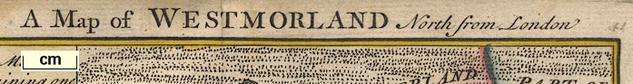
| map feature:- | compass rose & up is N & scale line & sea plain & coast form lines & rivers & lakes & relief & hillocks & county & settlements & roads | |
| inscription:- |
printed top
A Map of WESTMORLAND North from London |
|
| inscription:- |
printed bottom left, centre, and right
T. Badeslade delin. / Publish'd by the proprietor W H Toms Sept. 29. 1742 / W. H. Toms Sculpt |
|
| scale line:- | 10 miles = 25.5 mm | |
| scale:- | 1 to 630000 ? (1 to 631115 from scale line) | |
| wxh, map:- | 1148x144mm | |

|
||
|
||
| references:- |
Badeslade, Thomas: 1742: Chorographia Britanniae & Set of
Maps of all the Counties of England and Wales: Toms, William
Henry (London) Badeslade, Thomas: 1745: Chorographia Britanniae & New Set of Maps of England and Wales: Hitch, C & Toms, William Henry (London) Badeslade, Thomas: 1746 (?): Chorographia Britanniae & New Set of Maps of England and Wales: Clark, J & Hitch, C & Toms, William Henry (London) |
|
| sources:- |
Chubb 1927 (CLXX) Hodson 1984 HMCMS Map Collection JandMN Collection Wordsworth Trust Collection Armitt Library Kendal Library Maps Carlisle Library Maps |
|
| items seen (illustrated items in bold):- | ||

|
Armitt Library : 1959.191.1 -- map -- Map of Westmorland North from London | |
|
|
Armitt Library : ALMC2008.14.86 -- map -- Map of Westmorland North from London | |
|
|
Armitt Library : ALMC2008.14.87 -- map -- Map of Westmorland North from London | |
|
|
Armitt Library : ALMC2008.14.88 -- map -- Map of Westmorland North from London | |
|
|
Carlisle Library : Map 139 -- map -- Map of Cumberland North from London | |
|
|
Carlisle Library : Map 166 -- map -- Map of Westmorland North from London | |
|
|
Dove Cottage : 2007.38.61 -- map -- Map of Westmorland North from London | |
|
|
Dove Cottage : 2007.38.62 -- map -- Map of Westmorland North from London | |
|
|
Dove Cottage : 2007.38.63 -- map -- Map of Westmorland North from London | |
|
|
Hampshire Museums : FA1998.177 -- map -- England and Wales Divided into Counties | |
|
|
Hampshire Museums : FA1998.178 -- chart -- Sea Coast of England and Wales | |
|
|
Hampshire Museums : FA1998.179 -- map -- Great Roads from London | |
|
|
Hampshire Museums : FA1998.180 -- map -- Cross Roads from one Great Town to another | |
|
|
JandMN (18) -- map -- Map of Westmorland North from London | |
|
|
JandMN (115) -- map -- Map of Cumberland North from London | |
|
|
Kendal Library : Map 41 -- map -- Map of Westmorland North from London | |
|
|
Kendal Library : Map 42 -- map -- Map of Westmorland North from London | |
|
|
Kendal Library : Map 108 -- map -- Map of Westmorland North from London | |
|
|
private collection (162) -- map -- Map of Yorkshire North from London | |