 Badeslade 1742

|

|
|
|
item:- Armitt Library : ALMC2008.14.88 image:- © see bottom of page |
click to enlarge |
|
|
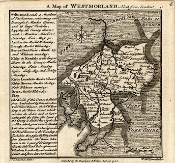
Map, uncoloured engraving, A Map of Westmorland North
from London, scale about 10 miles to 1 inch, with
descriptive text, by Thomas Badeslade, London, engraved and
published by William Henry Toms, Union Court, Holborn,
London, 1742.
Plate 41 in Chorographia Britanniae or A Set of Maps of all the Counties of England and Wales, etc. The engraving is an later state with more places and labels. |
||

|
Badeslade 1742 | |
| map feature:- | compass rose & up is N & scale line & sea plain & coast form lines & rivers & lakes & relief & hillocks & county & settlements & roads | |
| inscription:- |
printed top
A Map of WESTMORLAND North from London |
|
| inscription:- |
printed bottom left, centre, and right
T. Badeslade delin. / Publish'd by the Proprietors T. Badeslade & W H Toms Sept. 29. 1742. / W. H. Toms Sculpt |
|
| inscription:- |
printed above scale line
English Miles |
|
| scale line:- | 10 miles = 25.6 mm | |
| wxh, sheet:- | 17.5x16cm | |
| wxh, map:- | 148x144mm | |
| scale:- | 1 to 630000 ? (1 to 628650 from scale line) | |