 Badeslade 1742

|

|
|
|
item:- Hampshire Museums : FA1998.178 image:- © see bottom of page |
click to enlarge |
|
|
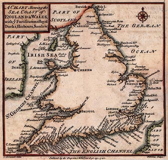
Chart, hand coloured engraving, the Sea Coast of England
and Wales, scale about 70 miles to 1 inch, by Thomas
Badeslade, engraved and published by William Henry Toms,
1742.
The map is from the beginning of an atlas; it shows The German Ocean ie North Sea, English Channel, Irish Sea, and St Georges Channel, with headlands, harbours, sandbanks, fortifications, etc, a few towns are marked. |
||

|
Badeslade 1742 | |
| map feature:- | plain cartouche & compass rose & coast form lines & harbours | |
| inscription:- |
printed title cartouche
A CHART Shewing the / SEA CAST of / ENGLAND & WALES, / with ye Fortifications Royal / Docks, Harbours, Sands &c |
|
| inscription:- |
printed bottom
T. Badeslade delin. / Publish'd by the Proprietor W H Toms Sept. 29. 1742. / W H Toms Sculpt. |
|
| scale:- | 1 to 4400000 ? (estimated) | |